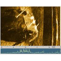
Submerged Pick-Up Truck Located Using Underwater Sonar
The James River is a tributary of the Missouri River. It is roughly 710 miles long and spans over 20,000 square miles of North and South Dakota with more than 70% of the river’s drainage occurring in South Dakota. River conditions during normal years include both still-water and flooding on both the James River and its tributaries. Water easily breaches the low banks, and these floods tend to cover a significant portion of the floodplain. When the river is still, water quality drops and it becomes quite difficult to see more than a few feet underwater.The Beadle County Office of Emergency
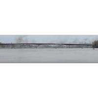
Sonar: Critical to Bridge Demolition, Recovery
is demolition.These jobs require caution and careful planning to guarantee safety and ensure that debris does not cause damage to the local waterways or roads. Four of the most common methods are bursting, hydraulic breakers, dismantling, and explosives.The Historic 1936 Highway 47 Bridge over the Missouri River was demolished this past spring. The old bridge was located 12’ from the new bridge that was built over the past several years. Being as close as it was, the demolition had to be precise, accurate, and safe. On April 11, 2019 the bridge was demolished via strategically placed explosives
IRPT: Missouri River Showing Progress
Inland Rivers, Ports and Terminals (IRPT) has anounced the newly formed working group “MO River Basin – Navigation Revitalization Committee”, designed to increase freight traffic and business on the Missouri River. IRPT has encouraged and received cooperation with associated marine, economic development and trade organizations to promote the healthy growth and operation of ports, terminals and intermodal centers along the Missouri River to boost foreign and domestic commerce, development and job creation throughout the river system. The first meeting was held this past