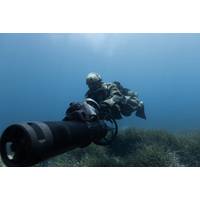
Ensuring Reliable Navigation for Tactical Divers
to designated targets and returning undetected.As part of the Artemis navigation system, the DVL measures velocity relative to the seabed. When integrated into the navigation system, this makes dead-reckoning navigation possible, providing navigation information for divers even in the absence of satellite signals As James Colebourn, Technical Sales Engineer at Blueprint Subsea, explains, “Once GPS drops out, the unit seamlessly switches to the DVL, just as any remotely operated vehicle (ROV) would, enabling accurate underwater navigation until the diver resurfaces.”Blueprint offers a variety
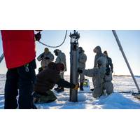
Rocket Scientists Build Antarctic Robot Probes
the ice or from vessels at sea.Although equipped with no form of propulsion, the robot probes would drift in currents, using special software guidance, to reach "grounding zones" where the frozen freshwater shelf meets the ocean saltwater and land. These cavities are impenetrable to even satellite signals."The goal is getting data directly at the ice-ocean melting interface," said Ian Fenty, a JPL climate scientist.Upon arrival at their targets, the submersibles would drop their ballast and float upwards to affix themselves to the underside of the ice shelf by releasing three-pronged

Quantum Sensor to Boost GPS-Free Navigation
that controls light on a microchip — as the cover story in the journal Science Advances.Accurate navigation becomes a challenge in real-world scenarios when GPS signals are unavailable. In a war zone, these challenges pose national security risks, as electronic warfare units can jam or spoof satellite signals to disrupt troop movements and operations.“By harnessing the principles of quantum mechanics, these advanced sensors provide unparalleled accuracy in measuring acceleration and angular velocity, enabling precise navigation even in GPS-denied areas,” Sandia scientist Jongmin Lee
Kongsberg Discovery Launches Seapath 385 Navigation System
the release of Seapath® 385, a system combining new hardware and advanced navigation algorithms to unlock optimal precision for hydrographic surveying.Seapath 385 combines inertial technology and processing algorithms with multi-frequency GPS, GLONASS, Galileo, Beidou, QZSS and geostationary satellite signals. The system integrates raw inertial sensor data either from Kongsberg Discovery’s high performance MGC® (Motion Gyro Compass) or MRU (Motion Reference Unit), together with GNSS data, and RTK, PPP or DGNSS corrections.The result is an integrated, robust and highly accurate solution
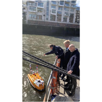
Water Drone Christened in the Port of Hamburg
at a time in the harbor to improve the understanding of the water depths and provide information about the condition of the quay walls. With its length of only 1.65 meters, the drone can also explore areas that were previously difficult to reach.There is no captain on board, but sonar, cameras and satellite signals navigate the USV. The course of the USV is monitored on land using a monitor, said Meier. "We are testing autonomous driving on the water here in real operation. To do this, we want to get the port customers used to the fact that such vehicles are in the port here between the normal ships
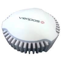
New GPS Interference Mitigation Solution
offshore oil and gas environment that can cause major delays in projects and impact vessel, operational and crew safety.The new antenna from VERIPOS, part of Hexagon’s Positioning Intelligence division, works to nullify the interference or jamming source that’s trying to overpower the satellite signals that GPS positioning systems use to determine location. With the source nullified, the receiver can acquire and track GPS signals while maintaining high-accuracy positioning.The technology that the VERIPOS GAJT 710-MS uses has been battle-tested and proven to work in some of the most demanding
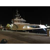
New Rescue Vessel Decked out with High-tech Equipment
water multi-beam echo sounder optimal for any high-resolution mapping and inspection application. The scope also includes an inertial sensor, Kongsberg Seapath 300, developed specifically for hydrographic and other high-precision applications. Seapath 300 combines inertial technology with GPS satellite signals. Sirius is also equipped with sound velocity sensors Valeport Midas SVX2 for profiling and Valeport miniSVS for surface measurement. Both sensors include digital time of flight sound velocity, and the SVX2 also acquires CTD profiling. The scope also includes a QPS QINSy hydrographic