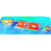
Surveyors Map Sunken Liberty Ship off Texas Coast
sunk at five different sites in the Gulf of Mexico. During deployment to the Freeport Liberty Ship Reef site in 1976, the Vancouver sank during a storm and settled to the bottom of the Gulf at its present position. Eleven other Liberty Ships and two tankers are located at other reef sites along the Texas coast. Brochures for these reef sites are available from the Texas Parks and Wildlife Department.(Image: TDI-Brooks)The multi-phase geophysical surveys were performed, all of which included integration of bathymetry, side scan sonar, sub-bottom profiling and magnetometer data. Side scan sonar data was

Enhancing Understanding of Gulf Sediments
Corps of Engineers has entered into a memorandum of understanding with the Bureau of Ocean Energy Management (BOEM) (a bureau of the U.S. Department of the Interior) and the Texas General Land Office (GLO) to streamline and synchronize Gulf of Mexico sediment resource identification data for use in Texas coastal protection and restoration plans and projects.According to the memorandum, a framework will be developed to collect and share data and optimize engineering, economic, and environmental criteria by matching potential sediment sources with future restoration projects and post-construction re-nourishmen
Harvey, Irma, Maria and Nate Retired
Atlantic basin list since 1953, when storms began to be named. The 2005 hurricane season has the most retired names (five) for one season. Summary of the newly retired storms Hurricane Harvey became a category 4 hurricane on the Saffir-Simpson scale before making landfall along the middle Texas coast on Aug. 25. The storm then stalled, with its center remaining over or near the Texas coast for four days, dropping historic rainfall amounts, of up to five feet, causing catastrophic flooding in parts of southeastern Texas. Harvey is the second costliest hurricane in U.S. history (after inflation)
The History of Offshore Energy
to the next. Going Deeper The deepest wells drilled to date are both dual oil and gas and are located in the Gulf of Mexico. The most remote and deepest is Shell’s spar Perdido, which was deployed in 2010, stands 9,600 ft., and sits in just under 8,000 ft. of water 220 miles off the Texas coast. Perdido functions as a common processing and exporting hub supporting a 30-mile radius of wells. Second in depth is the physically bigger Atlantis complex, located 190 miles south of New Orleans, covering an area with water depths ranging from almost 4,500 to just over 7,000 ft
Students Protect Inlets from Oil Contamination
A new Texas Tidal Inlet Protection Strategies (TIPS) program, being developed by researchers at Texas A&M University-Corpus Christi, will soon be in place to protect our state’s sensitive bays and estuaries from the potential harm of offshore oil spills. The bays and estuaries of the Texas coast serve as nurseries for several species of marine organisms including sport fish. These estuaries are connected to the Gulf of Mexico through various inlets. An oil spill in any of these sensitive habitats has the potential to kill fish and even shut down popular tourist areas. A spill could
Coast Guard Medevacs Diver 120 Miles off Texas Coast
A 33-year-old female diver was medevaced Thursday evening after she experienced decompression issues following her fourth dive, approximately 120 miles off Galveston. The doctor aboard the 96-foot passenger vessel Fling called Coast Guard Sector Houston-Galveston watchstanders at 7:50 p.m., to report the divers condition and ask for assistance. The watchstanders launched an aircrew aboard an MH-65 Dolphin helicopter from Air Station Houston. An HU-25 Falcon, from Air Station Corpus Christi was diverted to the scene to provide oversight of the response effort. The aircrew transferred the diver
$790,000 Grant Funds HRI Research of Sea Level Rise
The Harte Research Institute for Gulf of Mexico Studies (HRI) at Texas A&M University-Corpus Christi has received a $790,000 grant from the Houston Endowment for a ground-breaking project to map and evaluate the effects of sea level rise on the Upper Texas Coast and develop tools to address this critical issue. The program is the first of its kind in Texas to forecast changes to the environment caused by sea level rise and also examine the socio-economic impacts and public policy options for living with a rising sea. Since 1908, the tide gauge at Pier 21 on Galveston Island has recorded a
GOM Mission for New Research Ship
advance studies of artificial reefs, red tides & uncharted regions of the Gulf of Mexico. Scientists with the Harte Research Institute for Gulf of Mexico Studies (HRI) and the College of Science and Engineering at Texas A&M University-Corpus Christi will study the oceanography of the South Texas coast, including influences on the distribution of red tide while aboard the R/V Falkor later this month. The R/V Falkor is being provided by the Schmidt Ocean Institute free of charge for the study which is just one of many research projects that will be conducted by the scientists on the oceanographic


