Viridien Concludes Seismic Survey Offshore Malaysia
area.The new high-resolution long-offset dataset provides extensive seismic coverage and significantly enhanced imaging over this promising area.Viridien’s subsurface imaging experts have applied the company’s latest high-end imaging technologies, including full-waveform inversion and Q-tomography, for the first time in the Langkasuka Basin.“We are delighted to have successfully completed our first multi-client project offshore Malaysia, that leverages over 40 years of experience processing seismic data from one of the country’s major basins.“We are confident that this
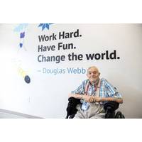
Teledyne Marine Pays Tribute to Doug Webb
Jones delivered an informative and historical talk about Webb’s legacy as an engineer, scientist, innovator, and world changer.Webb contributed significantly to developing low-frequency acoustic sound sources such as SOFAR, RAFOS, and Tonpilz for water mass tracking, long-range navigation, and tomography. He played a key role in the development of Vertical Current Meters (VCMs) to measure water chimney convection and profiling floats (ALACE). He commercialized this development (APEX) which became part of the ARGO program. He invented and developed the Teledyne Slocum gliders.Webb pioneered the
Opinion: A Call for the USNS Walter Munk to Honor America’s Greatest Oceanographer
and built upon similar work by the Navy to address climate change impacts on national security.More remarkable were Walter’s accomplishments in science as a whole. From unlocking the nature of ocean currents that is the basis of modern numerical models, pioneering research in ocean acoustic tomography and internal waves, developing modern methods of tidal time series analysis, to exploring unexplainable characteristics of sea level rise, the expanse of his impact on the field of geophysics is simply dizzying. When I was given the opportunity to steer National policy regarding ocean science and
WHOI Appoints Douglas C. Webb as Oceanographer Emeritus
out to develop and create a toolbox of long-endurance remote sensing platforms that would provide scientists with a better look into the world’s vastly under-sampled oceans. His innovative work includes low-frequency acoustic sound sources used for water mass tracking, long range navigation, and tomography (SOFAR, RAFOS, Tonpilz), Vertical Current Meters (VCMs) to measure water chimney convection, profiling floats (ALACE and APEX) that evolved into the ARGO program, and the genesis of ocean gliders (Slocum). The sound sources are still in use today for a variety of applications. The VCMs morphed
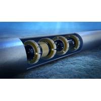
Pipeline Inspection with Fast(ER) Results
Finland’s Rocsole is hoping to provide operators with better, faster insight into their pipelines through a new compact inline sensor and a large dose of data analytics. Its inspection tool uses electrical tomography and digital signal processing to measure conductivity and permeability values within a pipeline. These are then analyzed to determine the content – fluid and solid – of pipelines or vessels, such as separators.The technology has had the backing of Shell, who are trialling the Deposition In-Line Inspection (DILI) in a 12 in. water pipeline in Brunei in October to detect

Researchers Use AI to Map Marine Environments
(DASA), a part of the Ministry of Defenwe, to improve monitoring of the UK’s vast marine territories using high tech sonar. SEA led the project and provided simulated sonar data to train and test the AI algorithms developed by the IMI.The technology could also be potentially used for ocean tomography across entire ocean basins, like the Arctic, to study the effects of climate change on the oceans and better enable the sustainability of human activities in fragile environments and ecosystems.Senior Lecturer Dr Philippe Blondel, from the University’s Center for Space, Atmospheric and Oceanic
Walter Munk: 1917-2019
Navy Chair in Oceanography until his death.One task assigned to JASON scientists regarding anti-submarine warfare led to Munk turning his attention to marine acoustics. This brought on another era of profound advances in the understanding of the oceans as his work led to the creation of ocean acoustic tomography and thermometry through which acoustic data became a vehicle for understanding currents, circulation, and heat content.The most famous example of this work might have been a Munk-led experiment to see whether acoustics could be used as a way to estimate ocean temperatures on a global scale and
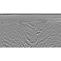
High-End Seismic Imaging Solves Shallow Gas Challenges
for the imaging consisted notably of a noise attenuation flow targeting swell noise, seismic interference and post-critical energy, as well as broadband de-ghosting, short- and long-period free-surface multiple attenuation, common-offset binning and regularization.The model building phase used both Q tomography and Q full-waveform inversion (FWI) to create a Q model which defined the location and extent of absorption anomalies. Advanced tomographic inversion and both refraction and reflection FWI were used alongside the Q work to derive the velocities and anisotropic parameters. This model building encompassed
TGS, Schlumberger reimaging central GOM
lease rounds and ahead of the large block turnover.” The custom-processing workflow for this project will include a number of newly developed imaging technologies including 3D WAZ de-ghosting; 3D surface related multiple elimination (SRME); common offset RTM gather (COR) and image-guided tomography; and orthorhombic anisotropy velocity modelling. During the reprocessing, geoscientists will update the salt interpretation and add input from the latest well data released for the area. The reimaging program is supported by industry funding. Fast-track data will be available in 2017 for lease