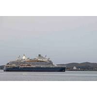
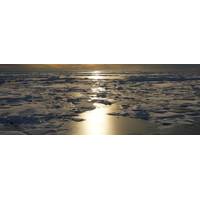
North Pole Marathon Offers Forum for Climate Change Science Aboard Icebreaker
is very important. And that means working across boundaries because the types of data that we need to understand what's happening and what the impacts are going to be, aren't things that one individual country can do on its own.”With Russia claiming "almost 50%" of the Arctic Ocean coastline, Spence highlighted the need for Russia to expand its global cooperation with other Arctic countries to collectively combat climate change.The environmental crisis in the Arctic also influences the insurance sector, Bolttech insurance services CEO Rob Schinek said during a talk at the
Coming in from the Cold: Canadian Arctic Security Takes Center Stage
, making a vast and sensitive region even more accessible to other nations with an interest in hitherto inaccessible transportation routes, natural resources, critical minerals and energy sources. By 2050, according to Canada’s 2024 defense policy “Our North, Strong and Free,” the Arctic Ocean could become the most efficient shipping route between Europe and East Asia. The Northwest Passage has already begun to see more activity and increased accessibility may allow Canada to build more of its own infrastructure, but that leaves the door open to outside interests seeking to capitalize
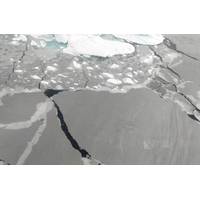
Naturally Quiet
;s Protection of the Arctic Marine Environment Working Group (PAME) has been studying shipping noise in the Arctic for a couple of decades, a short time in a bowhead whale’s lifetime and not even that long in a beluga’s lifetime.PAME found that noise levels in some places in the Arctic Ocean doubled between 2013 and 2019. Ship traffic continues to increase in volume, with some vessel types, including cruise ships, becoming larger as well.The latest PAME research indicates that, with no further policy action, by 2030, underwater noise from shipping will increase significantly in the
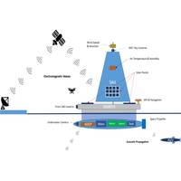
Autonomous Multi-Vehicle System Designed for Long-Term Arctic Studies
energy, ensuring continuous mission support even when sailing against ocean currents.Results of the study, published in the journal Applied Ocean Research, show that using the motion of a wind-driven sailboat to generate power from the turbine beneath the SWATH is a feasible way to support long-term Arctic Ocean monitoring missions.The UAVs use high-resolution cameras and sensors for mapping and navigation, while AUVs gather underwater data. The DJI Dock 2 system enables UAVs to autonomously land, recharge and redeploy, while an advanced underwater docking system allows AUVs to refuel and transfer data
An Arctic “Beyond Recognition” Expected by 2100
infrastructure, ecosystems, vulnerable communities and wildlife.”Under 2.7 degrees Celsius of warming, the Arctic region is likely to experience the following effects:• Virtually every day of the year will have air temperatures exceeding pre-industrial temperature extremes.• The Arctic Ocean will be free of sea ice for several months each summer.• The area of the Greenland Ice Sheet that experiences more than a month of surface temperatures above 0 degrees Celsius will quadruple compared with pre-industrial conditions, causing global sea levels to rise faster.• Surface-level
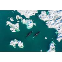
Arctic Sea Ice Could Reach Turning Point by 2027
to an international research team, including University of Colorado Boulder climatologist Alexandra Jahn and Céline Heuzé from the University of Gothenburg in Sweden. The team used computer models to predict when the first ice-free day could occur in the northernmost ocean.When the Arctic Ocean has less than 1 million square kilometers of ice, scientists say the Arctic is ice free.In September, the National Snow and Ice Data Center reported that this year’s Arctic sea ice minimum, the day with the least amount of frozen seawater in the Arctic, was one of the lowest on record since
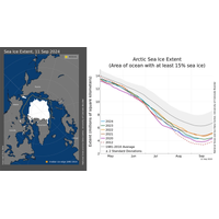
Arctic Sea Ice Reaches Seventh Lowest Extent on Record
is 12.4 percent per decade relative to the 1981 to 2010 average. From the linear trend, the loss of sea ice is about 77,000 square kilometers (30,000 square miles) per year, equivalent to losing the state of South Dakota or the country of Austria annually.“Every year brings something new for the Arctic Ocean,” said NSIDC senior research scientist Walt Meier. “This summer we saw very early ice loss in Hudson Bay, open water near the North Pole and a stubborn ice floe near the Bering Strait that persisted through the summer melt season. While it wasn’t a new record low, this year&rsquo

SAMS’ New Sensor Sheds More Light on Ocean Photosynthesis
expedition at 88° northern latitude and revealed that even in the Arctic far north, phytoplankton can build up biomass through photosynthesis as early as the end of March. At this time, the sun is barely above the horizon, so it is still almost completely dark under the snow and ice cover of the Arctic Ocean.Photosynthesis converts sunlight into biologically usable energy and thus forms the basis of all life on our planet. However, previous measurements of the amount of light required for this have always been well above the theoretically possible minimum.Fieldwork during the MOSAiC expedition deployed
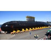
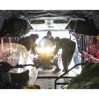
Canada Plans to Acquire Up to 12 Submarines
said.Canada updated its defense policy this year with a focus on protecting the Arctic and dealing with challenges from Russia and China. The procurement of submarines is a critical step in implementing that strategy, the defense ministry said in a statement.Citing global warming, Canada says the Arctic Ocean could become the most efficient shipping route between Europe and East Asia By 2050, thus raising the need to bolster maritime security."As the country with the longest coastline in the world, Canada needs a new fleet of submarines," Defence Minister Bill Blair said in the statement


