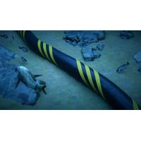
What We Need to Know About Telecommunications Cable Protection
.In response to the most recent suspicious severing of telecommunications cables in the Baltic, NATO's Center for Maritime Research and Experimentation in Italy launched software that will combine private and military data along with input from hydrophones, radars, satellites, vessels' Automatic Identification Systems and the distributed acoustic sensing fibers that are used to localize cuts in cables.All this technology is aimed at determining the cause of damage after the fact.Globally, around 150 cables are damaged each year, most by accidental human interventions such as dragged anchors, but
Struggles to Secure Baltic Sea Dominates NATO's 'Freezing Winds '24'
Head, Commander Pal Bratbak, said onboard the Weilheim, stressing the growing power of technology.NATO's Center for Maritime Research and Experimentation in Italy is launching software that will combine private and military data and imagery from hydrophones, radars, satellites, vessels' Automatic Identification System (AIS) and fibres with Distributed Acoustic Sensing (DAS), which private telecom companies use to localise cuts in their cables."If we have a good picture of what's going on, then we can deploy units to verify what the system tells us," Bratbak said.German Lieutenant-General
Ukraine's Drone Success Shapes US Pacific 'Hellscape' Strategy
drones has freed up crucial shipping lanes to allow greater grain exports from Ukrainian ports.Last month, shipping intelligence firm Lloyds List reported that foreign grain cargoes from Ukrainian ports were now almost back to their prewar levels, although many ships were turning off their automatic identification signals while passing through the war zone. Some successfully targeted Russian vessels include sunken frigates, landing craft and a heavily damaged submarine.On land, flying drones that can be remotely piloted by a headset to their targets are now reported to be causing more casualties on
Maritime Risk Symposium 2024 – Great Power Competition and Gray Zone Engagement
conflict, making attribution and response difficult. Artificial intelligence (AI) offers promising solutions to enhance the detection, analysis and mitigation of gray zone cyber threats in the maritime sector. This panel will explore the potential of AI to counter tactics like GPS spoofing, Automatic Identification System manipulation and attacks against port infrastructure. It will examine how machine learning-based systems can identify anomalies in network behavior, detect subtle patterns associated with gray zone activities and automate threat intelligence analysis. The panel will also address the
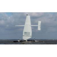
Saildrone Launches First Next-gen Surveyor USV
the first vehicle launched of many that will be produced here in Alabama,” said Saildrone founder and CEO Richard Jenkins. “Everyone at Saildrone is very proud to be supporting the US Navy and contributing to our defense and national security.”The Surveyor fuses radar, cameras, automatic identification system (AIS), and advanced machine learning to deliver comprehensive situational awareness remotely from anywhere in the world. Saildrone offers solutions for challenges like IUU fishing, counter smuggling, and safety of life at sea (SOLAS) missions. The Surveyor detects vessels at sea,
As the Clock Ticks on the Titan Sub, an Expert Explains What Safety Features a Submersible Should Have
ensured instant two-way communication and a higher data exchange rate. But these cables can get entangled with potential hazards at a shipwreck site.As such, tethers are mostly used for unmanned vehicles; manned submersibles prefer to trust the pilot. Also, GPS, portable satellite phones and automatic identification systems can’t be used underwater. These tools use electromagnetic waves that don’t propagate deep underwater (although they could be used on the surface).Some submarines are equipped with a distress beacon, the equivalent of an emergency position indicating radio beacon (EPIRB)
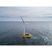
Floating Offshore Wind: New Seascape, New Challenges
.” Wise said the NSRA tells the Coast Guard what objects will be placed in the waterway. He added that various states may also require additional permits or approvals, particularly within a state’s three-mile offshore ocean boundary.Traffic analysis is done using AIS – automatic identification systems – data. AIS tells what kind of ships are in a proposed WEA and the vessels’ locations.The NSRA outlines the steps needed to avoid and minimize navigation conflicts. This is critical not just for safety but, Wise added, because it impacts the layout of the project within
Sea Machines Debuts AI-ris Computer Vision for Commercial Vessels
or animals, to those very large, like another ship,” said Trevor Vieweg, CTO, Sea Machines. “With the ability to detect, classify and geolocate such targets via optical sensors, AI-ris augments and surpasses the capabilities of existing marine sensor technologies, like radar and automatic identification system (AIS), enabling greater performance and achieving the highest levels of safety. In the future, this technology may also help responders detect marine oil spills.”AI-ris is commercially available now and can be installed aboard existing vessels, as well as new-builds
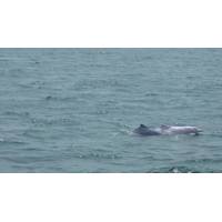
Unmanned Vessels Help to Protect Threatened Marine Lives in China
with Pearl River Estuary Chinese White Dolphin National Nature Reserve.Besides population exploitation, USV technologies also play significant roles in guarding the natural reserve. An autonomous surveillance and rescue vessel is also used for daily patrolling along the set route. Radar and AIS (Automatic Identification System) are applied to real-time monitoring, automatically recording vessels' sailing paths and alerting suspected vessels. Natural reserve protection has become more intelligent and efficient with advanced USV technologies.The Autonomous Surveillance and Rescue Vessel is Expelling a


