Podcast: Fascinated by Shipwrecks; USS Monitor Digitally Reimagined
first-of-its-kind rotating gun turret.Monitor was launched on January 30, 1862, and on March 9th, famously fought the Virginia at the Battle of Hampton Roads. Despite the battle being a draw, it effectively signaled the end of age-of-sail naval warfare. Monitor was lost on December 31 in a storm off Cape Hatteras, taking 16 of her officers and crew with her.In this episode, host Kathy A. Smith talks with NOAA’s Tane Casserley about Monitor, plans for the 50th anniversary of the Monitor National Marine Sanctuary, and how digital technologies are reimagining the way the public interacts with the iconic
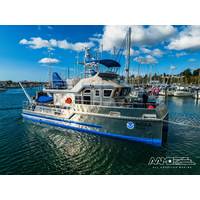
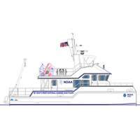
All American Marine Launches New Research Vessel for NOAA
Marine Sanctuary System, governed by the National Marine Sanctuaries Act. Gray’s Reef National Marine Sanctuary stands as the lone safeguarded natural reef zone along the Georgia coast’s continental shelf, and it’s a rare gem in the broader expanse of the ocean, extending from Cape Hatteras, N.C., to Cape Canaveral, Fla. This sanctuary, spanning approximately 22 square miles (roughly 14,000 acres), may be a modest segment of the vast U.S. territorial Atlantic Ocean, but its significance as a pristine marine habitat garners recognition both nationally and internationally.“We
AAM to Build Research Vessel for NOAA Gray’s Reef National Marine Sanctuary
System, governed by the National Marine Sanctuaries Act. Gray's Reef National Marine Sanctuary is currently the only protected natural reef area on the continental shelf off the Georgia coast and one of only a few natural marine protected areas in the ocean between Cape Hatteras, NC and Cape Canaveral, FL. The approximately 22 square mile sanctuary (about 14,000 acres) of Gray's Reef is just a small part of the U.S. territorial Atlantic Ocean, yet its value as a natural marine habitat is recognized nationally and internationally, AAM said.&ldquo
Measuring the Hostile Ocean Beneath Hurricanes
upper ocean in the Western North Pacific during Typhoon Soulik in 2018. Upper pane in-situ data observed with a Slocum glider. Lower panel: Output from a computer model. Box highlights region discussed in text. Credit: Rutgers UniversityIn the mid-Atlantic Bight, which extends from Cape Cod, MA to Cape Hatteras, NC, the continental shelf is shallow. Its deep waters are well documented to be much colder than surface waters during summer time. Considering the oceanic upwelling below the eye of a storm, the surfacing of these cold waters might be expected to weaken a passing hurricane.Two Slocum gliders
#Oi2020 History
began with just a few key clues, specifically a letter from J.D. Winchester, the acting master of the USS Sumpter, which explains how (while being towed from Washington DC to Charleston, SC) the Alligator came loose during a storm in 1863, forcing the Sumpter crew to cut the vessel loose off Cape Hatteras, NC. With this in mind, the survey began in “The Graveyard of the Atlantic,” in Ocracoke, NC, (off Cape Hatteras). Using details provided in Winchester’s letter, (along with available information about the Alligator and an analysis of the oceanographic and meteorologic
Full-Depth Current Profiling Around the Global Ocean
to 3000 m. US scientists collected LADCP data on two visits separated by 3 months during WOCE. The depth of the Great Whirl’s currents increased from 200 m to 2500 m. Due to the deep reach of these currents, the volume of water moving in the Great Whirl matches the flow of the Gulf Stream off Cape Hatteras. The deep reach of the Great Whirl is one proposed explanation for reversals in the abyssal circulation below. These too were observed with LADCPs.Data BlendingOceanographers explored new ways to merge the LADCP information with water properties observed during the hydro casts. Ocean currents
NOAA Names Pentony Atlantic Fisheries Administrator
He succeeds retiring Regional Administrator John Bullard who had been in the position since 2012. Pentony will head the agency’s regional office, which has responsibility for managing approximately 100,000 square miles of the Northwest Atlantic, the large marine ecosystem from Maine to Cape Hatteras and the Great Lakes. As Administrator, he will also oversee aspects of international fisheries conservation and management in the region. Before joining NOAA Fisheries in 2002, Pentony worked for five years as a policy analyst for the New England Fishery Management Council, primarily
Research Vessels: The Fleet is In
teachers, students and community members. Researchers and instructors from other institutions will also be able to charter the vessel for scientific or educational purposes. Duke said its marine lab has been without a large research vessel since two of its boats were retired—the 135-foot Cape Hatteras in 2013 and the 50-foot Susan Hudson in 2014. Faculty members have since been unable to regularly take students offshore or participate in oceanographic work. The new vessel will allow researchers and other institutions to conduct research along the Atlantic seaboard in a wide range
Duke Receives Funding for New Research Vessel
School. “We’re delighted that our benefactor shares our commitment to the lab’s vital educational, research and science outreach missions.” Duke said its marine lab has been without a large research vessel since two of its boats were retired—the 135-foot Cape Hatteras in 2013 and the 50-foot Susan Hudson in 2014. Faculty members have since been unable to regularly take students offshore or participate in oceanographic work. “Our small vessel, the Richard Barber, is a great platform for daylong research trips, but is not able to support overnight


