GeoSphere: Mapping-while-drilling Evolution
understanding of the reservoir while bring drilling into a new area of efficiency and cost savings. Marine Technology Reporter’s Correspondent in Brazil spoke to Jean Seydoux, Program Manager for Advanced Reservoir Mapping Technologies for Drilling and Measurement at Schlumberger, about their GeoSphere Mapping-While-Drilling Service. What were the breakthroughs in this technology’s development along the last five years? In 2014, Schlumberger introduced the GeoSphere technology, the first-ever reservoir mapping-while-drilling service that enables customers to map their reservoirs
NOAA Names Werner Director of Scientific Programs
was co-Editor in Chief of the journal Progress in Oceanography. Cisco was Chair of the Global Ocean Ecosystem Dynamics Program’s (GLOBEC) Scientific Steering Committee: 2003-2007; Chair of the Gordon Research Conference on Coastal Circulation Modeling, 2007; member of the International Geosphere-Biosphere Program (IGBP) Scientific Steering Committee from 2003-2007; member of NSF’s ORION iOSC 2007 & Science and Technology Advisory Committee (STAC) 2005-2007; member of the U.S. GLOBEC Scientific Steering Committee from 2000-2007; co-Chair of the PICES MODEL Task Team, 2001-2007
OTC Names Technology Award Winners
Well Testing System Oceaneering International, producer of Deepwater Pile Dredge Oceaneering International, producer of Magna Subsea Inspection System OneSubsea, producer of Multiphase Compressor SBM Offshore, producer of ARCA Chain Connector Schlumberger, producer of GeoSphere reservoir mapping-while-drilling service Schlumberger, producer of Quanta Geo photorealistic reservoir geology service Tracerco, producer of Tracerco Discovery Versabar, Inc., producer of VersaCutter Weatherford, producer of Red Eye Subsea Water-Cut Meter Weatherford, producer

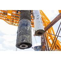
Schlumberger Debuts GeoSphere
Schlumberger introduced the GeoSphere reservoir mapping-while-drilling service. The new technology reveals features in subsurface beddings and fluid contacts at the reservoir scale to optimize well landing operations, steering capabilities and mapping of multiple boundaries using new deep-directional resistivity measurements enabled by proprietary real-time interpretation techniques. “With GeoSphere technology, Schlumberger is introducing the first-ever reservoir mapping-while-drilling service that enables customers to map their reservoirs using unprecedented depth of investigation
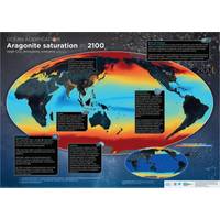
Report: Ocean Acidity is Increasing ... Rapidly
from November 11 to 22. The document represents the conclusions of 540 experts from 37 countries reflecting the latest research on the subject. It was prepared by UNESCO’s Intergovernmental Oceanographic Commission (IOC), the Scientific Committee on Ocean Research (SCOR) and the International Geosphere-Biosphere Program (IGBP). It emerges that all the oceans, which together absorb close to one quarter of CO2 emissions generated by human activity, have experienced an overall 26% rise in acidity since the dawn of the industrial age. Twenty-four million tonnes of CO2 are absorbed by the seas