Unmanned Vessel Launched to Survey Western Galveston Bay
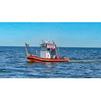
An unmanned vessel is now surveying more than 3,500 nautical miles of the Western Galveston Bay, near the Houston Ship Channel.DEA Marine Services, a division of David Evans and Associates, Inc. (DEA), in Vancouver, Wash., equipped its survey boat Sigsbee with a Sea Machines Robotics SM300 autonomous-command and remote-helm control system to fulfill a National Oceanic and Atmospheric Administration (NOAA) contract.Sigsbee, which is serving as an autonomous daughter craft for the project, is effectively doubling coverage by operating without an onboard crew, while collaboratively following another
MWCC Completes GoM Shore Base Locations
find additional storage and maintenance capabilities for our equipment,” said MWCC CEO Marty Massey. “We are confident in our selection and this milestone helps MWCC further fulfill its mission to be continuously ready to respond.” The interim system, previously housed on the Houston ship channel and in Fourchon, Louisiana, has been permanently moved to new shore base facilities located in Theodore, Alabama (near Mobile) and Ingleside, Texas (near Corpus Christi) in order to accommodate the expanded system which is expected to be available later this year. The shore base at Theodore
Mobile App Boosts Navigation Safety
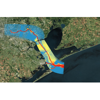
Institute Develops Mobile App to Increase Navigational Safety along Nation’s Second-Largest Port. Researchers have designed and are implementing a new mobile application to provide ship captains and pilots with real-time predictions of ocean water levels and currents along the Houston Ship Channel, which services the second-largest port in the United States, the ports of Houston and Galveston. The app will provide invaluable information, which could increase navigational safety along the ship channel by reducing the number of ships becoming grounded due to insufficient water