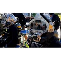
US Navy Divers Get Augmented Vision Display
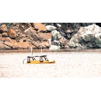
also employed the DAVD 3D sonar systems to assist in salvage efforts after the March 2024 collapse of Baltimore’s Francis Scott Key Bridge. And DAVD was instrumental in efforts to map the murky waters surrounding the sunken USS Arizona. The purpose was to help U.S. Pacific Fleet and the National Park Service inspect the condition of submerged, severely degraded construction moorings used to build the memorial in the 1950s.Potential upgrades to DAVD could include GPS for georeferencing (relating a digital map or image to geographic coordinates), physiological monitoring such as an eye-tracking

Shipwreck Podcast: Exploring Tragedy, History & Humanity with James Delgado
than I think most of us realize.” James P. DelgadoJim talks about his long, storied career, starting with his budding interest in archaeology and history at age 10, and how his career path changed when he was exposed to the buried San Francisco Gold Rush ship Niantic while working for the National Park Service.He also gives moving accounts of famous shipwrecks that have had a profound emotional impact on him. These include Clotilda, the last known U.S. slave ship to bring captives to America, USS Arizona, and the sunken ships at Bikini Atoll in the Marshall Islands, the site of nuclear bomb tests
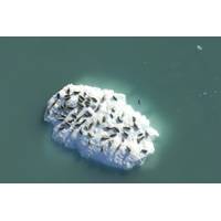
Seals Have Preferences for Different Icebergs
led the study. “Interdisciplinary studies like this one coupled with long-term monitoring campaigns will be important to understand how climate change will influence tidewater glacier fjord ecosystems in the future.”Kaluzienski, university colleagues, and collaborators from the U.S. National Park Service spent the last few years documenting fine-scale variations in icebergs and in the distribution of seals in the fjord, using time-lapse cameras and aerial photographic surveys. When an iceberg breaks away from a glacier, its speed and path are affected by wind, ocean currents and freshwater
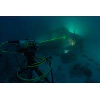
Subsea Wreck Brought to Life by Lasers
of materials conservation of watercraft and aircraft with the Conservation Research Laboratory and Center for Maritime Archaeology and Conservation (CMAC) at Texas A&M University, the Devastator Project team consisted of Brett Seymour, a top-flight underwater photographer on loan from the National Park Service's Submerged Resources Center; Evan Kovacs, an innovative engineer and experienced technical diver who runs Marine Imaging Technologies; Matt Christie, Senior Subsea LiDAR Specialist with 3D at Depth; Brian Kirk, an expert local guide and original co-discoverer (with historian/explorer
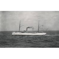
US Coast Guard Shipwreck Found – 100 Years Later
courthouse for far-flung Alaskan towns. Last October, a joint NOAA and Coast Guard training mission confirmed the location of McCulloch’s remains. Working off the Channel Islands National Marine Sanctuary’s research vessel Shearwater, the multi-agency science team from NOAA, National Park Service, and Coast Guard Dive Lockers Alameda and San Diego, deployed a VideoRay remotely operated vehicle to survey and characterize the shipwreck. Coast Guard 11th District cutters Halibut and Blacktip provided vessel support. Cameras mounted on the remotely operated underwater vehicle
Case Study: Mapping a Glacial Landslide
. The goals of that trip were to map the fjord floor with multibeam sonar and other seismic geophysical techniques that would allow them to see below the surface to determine the thickness of the landslide debris. Along with Shugar were a large group of scientists from Columbia University, the National Park Service, University of British Columbia and elsewhere. The team’s plan was to map the submarine deposits with the UW-Tacoma’s Z-Boat 1800 RP named ‘Jökull’ (Icelandic for glacier) with help from Jeremy Venditti, a professor from Simon Fraser University in Canada
Gulf Coast Coastal Restoration Work Awarded
off the coast of Mississippi which was breached during a hurricane. It is a critical piece of infrastructure that helps mitigate the damage caused by storms, thereby helping to protect communities. We look forward to working with U.S. Army Corps of Engineers, Mobile District and the National Park Service as we execute this important project.&rdquo
View from the Top: Dr. James Delgado, NOAA Director of Maritime Heritage
called him to his future path. He rescued more than 100 burials from destruction as well as many artifacts. The skeletal remains were reburied by the Ohlone descendants. Later, beginning in his junior high school years, he began working with local archaeologists, and at age 20, joined the National Park Service. There, he learned to scuba dive while working as an historian and archaeologist for the National Park Service in San Francisco. Not surprisingly, his career has taken him all over the globe and to several hundred fathoms under the sea. He has been part of some of the world&rsquo
BOEM Proposes New Regulation for OCS
restored more than 269 miles of coastline. BOEM has established strong and effective partnerships, including those with state geological surveys and environmental agencies, the U.S. Army Corps of Engineers, U.S. Geological Survey, National Marine Fisheries Service, U.S. Fish and Wildlife Service, National Park Service, National Aeronautics and Space Administration, and the Department of Defense. The Secretary of the Interior was authorized to negotiate non-competitive agreements for the use of these marine minerals for coastal restoration by an Outer Continental Shelf Lands Act amendment in 1994. Since


