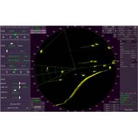
Sperry Marine Debuts Additional Military Layers on VisionMaster Radar and ECDIS
Sperry Marine has strengthened its portfolio of military navigation solutions with the release of Additional Military Layers (AML) for its VisionMaster series of Radars and ECDIS.The AMLs have been developed to allow defense and naval users to take advantage of Sperry’s commercial radar systems on demanding military assignments on small and large vessels. The latest enhancement supports the display of AMLs created to support both command and control and provide digital navigation systems that ensure the best situational awareness available for marine operations.By combining the navigational
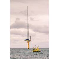
UK Gov't Sets Aside $5M for Tech That Can Mitigate Offshore Wind Farms Impact on Radar Systems
The UK Gov't has announced Phase 2 of the competition "Windfarm Mitigation for UK Air Defence," offering up to £3.6 million ($4,96 million) for technologies that mitigate radar risk of offshore wind farms."The continued development of wind turbine sites can have an adverse impact on civil and military air traffic control, and air defense surveillance. If you think you have an idea that can be developed to support the coexistence of offshore windfarms and UK air defense systems, DASA would like to see your technology in Phase 2 of the competition,” the UK Defence
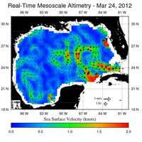
New Research on Gulf of Mexico Loop Current
were chosen to conduct specific studies or collect particular data and observations identified in the NASEM report as short-term needs to assist with the long-term research campaign:Dry Tortugas and Lower Keys High Frequency RadarsThis project will procure, install, and operate high frequency radar systems to measure surface currents at three locations in the Straits of Florida region of the Gulf of Mexico: Fort Jefferson/Dry Tortugas National Park, Key West, and Marathon. Data from the systems will provide new, real-time data for model assimilation and validation to better understand the evolution
Ocean Radar Detects Mini Tsunami 40 Minutes before Impact
more than 2 meters tall, sweeping away beach chairs, boats and parasols. No one was seriously injured, thanks to the fact that the wave reached the beaches very early in the morning, at about 5:30 am local time. About 50 kilometers southwest of Zandvoort there are two WERA ocean radar systems installed at Monster and Ouddorp. These systems are owned by Rijkswaterstaat (a part of the Ministry of Infrastructure and the Environment) and measure the ocean currents around the entrance of the Port of Rotterdam. The operational frequency is 16.175 MHz providing a coverage of up to 70 kilometers
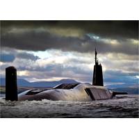
‘A Step Forward in Submarine Radar Technology’
radar technology to submarines. Traditionally, submarines only use radar for navigation in and out of port because a high power RF transmission can compromise its ability to remain undetected. However, with its low power output – up to 300W as opposed to the 25kW of legacy submarine radar systems – SharpEye can reduce the probability of detection by ESM systems. Due to the solid state technology at the heart of SharpEye, it is now possible to locate the X-band transceiver downmast within the pressure hull, making use of the existing bulkhead infrastructure and the existing
Two Simrad Radar Displays Launched
space for additional vessel data, radar settings and target tracking information. Menus can be operated without obscuring the radar image for safe and efficient control. An HDMI output is available to set up an optional secondary remote monitor. “These new dedicated radar systems are well suited to our award winning products such as the Halo Pulse Compression Radar,” said Jose Herrero, MD Simrad Commercial Division, adding “Our team, continually strives to develop innovations that simplify the user experience and improve operational performance for our commercial
WindSentinel Floating LiDAR Helps Cut Costs
equipped with anemometers and extrapolate those measurements across the length of the wind farm. To measure sea states, wave buoys and weather forecasting models are used. Standards for monitoring bird and fish populations are still being developed, but may include use of observers and sophisticated radar systems. The WindSentinel floating LiDAR eliminates the need to construct a meteorological mast and provides all the required data from a moveable and low environmental-impact buoy. Floating LiDAR decreases the overall cost and time to market of offshore wind developments. Design Drivers The WindSentinel
Planet OS Joins AWS for NOAA's Big Data Project
OS. NOAA data plays an important role for Planet OS. NOAA gathers more than 20 terabytes of data every day -- more than twice the data of the entire printed collection of the United States Library of Congress. This environmental intelligence comes from a wide variety of sources, including radar systems, weather satellites, buoy networks and stations, tide gauges, real-time weather stations, as well as ships and aircraft. However, only a small percentage of this valuable data is currently easily accessible to the public. The demand for this data has increased and it is imperative to find ways
Newfoundland and Labrador: Sensing Success
organizations to specialty start-ups, the province is increasingly excelling in this high technology category. Rutter Inc. has spent more than 20 years developing a proprietary suite of radar technologies including its Sigma S6 system, which has helped it lay claim as the largest supplier of ice radar systems in the world. Its technology is largely used in the global oil and gas industry, with oil spill, and wave and ocean current monitoring added to its proprietary suite, along with small target monitoring utilized in other sectors such as homeland security. “Generally, a very harsh environment