The Coldest Place in the Universe
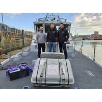
A UK company has reached a temperature of minus 273.149996°C in the quantum technology it uses in its atomic clock, effectively creating the coldest place in the universe. It’s a high-tech solution for an age-old problem: accurate navigation at sea without the support of satellite systems.Alexander Jantzen, Co-founder & Chief Operating Officer at Aquark Technologies, explains: “At the beginning of the 18th century, knowing your latitude when navigating was long understood by observing the position of known distant stars above the horizon, however the longitude was a dangerous
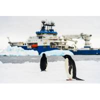
Schmidt Ocean Institute Successfully Concludes Inaugural Antarctic Expedition
(ROV) SuBastian to assess biodiversity and explore vents and seafloor mapping. Ice pilots and crew transported scientists via small boats to places like Joinville Island, off the northeastern tip of the Antarctic Peninsula, for research on marine mammals and sea birds.The ship’s satellite systems also live-streamed ROV dives, connecting the global population with the Antarctic seafloor. The rare sights included icefish guarding their eggs, cold Antarctic seep environments characterized by bacteria feeding on chemical energy, and dense sponge and kelp outcrops in frigid minus 1 degree

Less is More with Gyroscopes
as the AUVs go deeper and perform a wider range of data collection tasks, FOGs continue to be part of the GNSS-denied navigational systems that enable them to do it.The FOG sensors in an inertial navigation system measure changes in orientation of the AUV to support navigation by dead reckoning as satellite systems such as GPS are not available subsea. FOGs operate by monitoring the difference in propagation time between beams of light traveling in clockwise and counterclockwise directions about a closed optical path. Two beams of light are sent in opposite directions in a fiber optic coil. As the vehicle
Inside the new UK Center for Seabed Mapping
gaps, Parker said the big shift was the move to multibeam echo sounders and bathymetric LiDAR systems, which unlike that single beam isolated profile, generates a full picture of the seabed, said Parker.“I think the second pick is a fairly obvious one for me, the advent of global navigation satellite systems,” said Parker. “It's easy to forget that GPS on your phone or GPS on your ship is a relatively recent thing. When I started in the '90s, the United States GPS was just starting to become available for civil use, but it was limited in terms of its constellation.”At
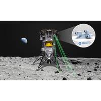
Advanced Navigation Wants to Be First Australian Firm to Reach the Moon
to being the first Australian company to reach the Moon in 2024, this will be a huge milestone for us,” said Xavier Orr, CEO and co-founder at Advanced Navigation.“Inertial and robust reference-based navigation is a critical capability in space missions, where terrestrial navigation satellite systems, such as GPS are non-existent. Our lightweight technology is estimated to deliver $85 million in value for lunar missions, helping to deliver heavier payloads to further advance research, exploration, and commercial developments on the Moon.”According to the company, developed from over
Autonomous Navigation – with or without GNSS
to reduce cost, risk to humans and our carbon footprints.But they don’t come without challenges. Because they’re unmanned and require control remotely, we are even more reliant on having accurate navigation systems onboard and currently that largely rests on Global Navigation Satellite Systems (GNSS).As a primary navigation source, GNSS is well used, but there are conditions where purely relying on it could create some risks. This could be where line of sight to a GNSS constellation is lost while transiting under bridges or through busy harbours, or near significant structures, such
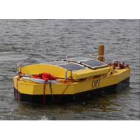
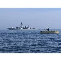
Ocean Power Technologies Launches Hybrid PowerBuoy
also available, including the addition of subsea sensors to monitor for acoustic signatures, tsunami, and other environmental conditions," OPT said.Data from the hybrid PowerBuoy is transmitted to shore-based command stations via communications networks, including WiFi, cellular, mesh and/or satellite systems, depending upon location. Data can also be integrated with satellite, terrestrial, and other data feeds to form a detailed surface and subsea view.OPT recently put the first hybrid PowerBuoy through an initial sea trial that included several tow configurations, roll and pitch stability measurements
Project to Enable Autonomous Navigation in Denied Environments
A new project involving leading ship technology companies aims to help unmanned autonomous vessels navigate, even when they lose access to global navigation satellite systems (GNSS). The project will combine underwater positioning systems from Sonardyne International Ltd. and Guidance Marine Limited’s relative surface positioning systems into one integrated solution to enable vessels to maintain safe passage in GNSS-denied environments or for dynamic positioning systems to maintain their position if they lose GNSS access or other sensors fail.The AutoMINDER (Autonomous MarIne Navigation in

Shell Ocean Discovery XPRIZE Announcements at OI2018
Vision Survey of Offshore Structures’ (15.15-15.35) with Diego Carvalho, Vision Engineer, Fugro Intersite; and ‘Towards Resilient Positioning’ (11.20-11.45) with Dr Nick Ward, Research Director, General Lighthouse Authorities of the UK & Ireland. “Global Navigation Satellite Systems have become essential for maritime positioning,” says Dr Ward, “but they are vulnerable to disruption. There is a need for an integrated approach to positioning using all available means.” In addition to the insights provided by the exhibition and main conference schedule


