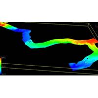
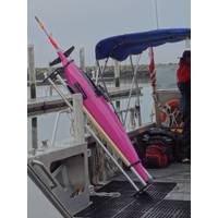
Bathymetric Drone Survey with Multisensor Tech
systems for land and underwater surveying, complicating data integration and increasing project time and cost. Moreover, the need to survey under vegetation and achieve depths of up to 100 meters underwater demanded a solution that could provide exceptional precision and versatility.The Multisensor SolutionAeromedia utilized an innovative approach to address these challenges by integrating three technologies.This multi-sensor solution enabled the team to measure the Earth's surface seamlessly, capturing accurate information from the Digital Terrain Model (TDM), even in areas covered by vegetation
MBARI Works at Unlocking Ocean Biology
enough to store the number of samples that would be needed or carry the laboratory equipment that could do onboard analysis – until now. A team at Monterey Bay Aquarium Research Institute (MBARI), based at Moss Landing, California, has been working on a so-called “ecogenomic” sensor solution for over the last 25 years and it’s now been getting results, as part of multi-vehicle missions on and beneath the surface.Dr. Jim Birch, director of MBARI’s SURF center, says it started with a group interest in microbial oceanography – the study of the smallest organisms in
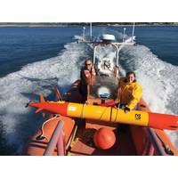
KUTI Delivers First Vehicle with RSI Turbulence Sensor
the first Seaglider vehicle equipped with a Rockland Scientific International (RSI) MicroPod turbulence sensor. The vehicle was commissioned by the University of East Anglia in the UK (UEA). The MicroPod package is the result of collaboration between KUTI and RSI in an effort to develop a sensor solution that is suitable for integration on Seaglider’s low drag composite fairing. This sensor configuration minimizes any potential impact on the high glide efficiency of the Seaglider. Ocean turbulence is being recognized as an increasingly important parameter for understanding and
Optech Announces Titan
verticals and application requirements. Titan breaks away from this convention by combining three beams with separate wavelengths, increasing the information content that can be derived from the target surface and allowing surveying professionals to address many more applications using a single sensor solution. Whether the goal is high-precision, high-density topographic surveying, land cover classification, vegetation mapping, or shallow water bathymetry, the Optech Titan can accommodate them all. According to Michael Sitar, Optech’s Business Manager for Airborne Mapping Solutions, &ldquo
E-scan Radar Enhanced for Coastal and Harbor Security
processing filters out sea wave clutter returns in both velocity and amplitude; detects very small and slow moving targets (smugglers and pirates in kayaks, RIBS etc.) in rough seas, heavy rain and fog out to 10km Blighter Surveillance Systems, a British electronic-scanning (e-scan) radar and sensor solution provider, has enhanced its Blighter e-scan radar's effectiveness for coastal and harbor security with a raft of new features including a sea wave clutter filter. The new features will enable its radar to protect complex coastlines from intruders such as smugglers, pirates, illegals and terrorists