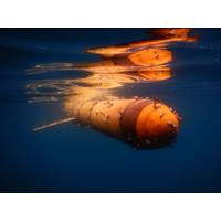
NORBIT Introduces WINGHEAD X Sonar
;s innovative modular platform, it offers complete operational flexibility, allowing users to configure their sonar to meet specific survey applications and hydrographic requirements.The company offers Long Range or Standard configurations, Integrated GNSS/INS or Non-Integrated options, and software features such as yaw stabilization, pitch stabilization, dual swath and more
Wintershall Noordzee Deploys Wärtsilä Software to Boost Offshore Safety
Dutch offshore oil and gas operator Wintershall Nordzee has recently seen Wärtsilä's Navi-Harbour WebVTS 5.0 software application for its platform in the Dutch North Sea.The software features an early warning system to avoid allisions between the offshore platforms and vessels in their vicinity. It works by providing remote access to Automatic Identification System (AIS) or Vessel traffic Service (VTS) data sources to maintain constant and full situational awareness, using a standard internet browser. "The WebVTS decision support tools effectively mitigate potential marine
"An Epic Mission": Slocum Glider "Silbo" Circumnavigates the Atlantic Ocean
close to 5000 CTD casts that aided metalogical forecasting. With partners from Rutgers University and its student base, UVI, PLOCAN, UGCLP, the Marine Institute, and others, Silbo also participated in the Challenger glider mission. Silbo has been a test bed for many new engineering hardware and software features for both existing and next generation Slocum gliders. Recent legs have provided data on new battery configurations, advanced software, and techniques for piloting long endurance missions and minimizing biofouling. Silbo’s accomplishments have been critical in the glider community&rsquo
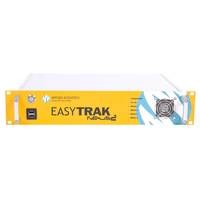
STR Doubles Order from Applied Acoustics
;so having these available to the worldwide rental market through STR is a great endorsement of the product and an important facet of our company strategy.” STR now offers its clients access to the Nexus 2 system that provides 16 target tracking as well as a new comprehensive range of software features and survey tools such as the common interrogate frequency (CIF), greatly enhanced accuracy and geo-referenced graphical overlay. Scott Johnstone, Managing Director at STR commented, “As providers of specialist marine equipment and supporters of Applied Acoustics’ products
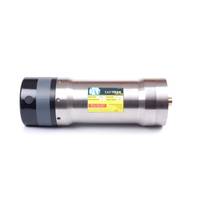
Nexus 2 USBL Available for Rent in the U.S.
by the Great Yarmouth, U.K., based company. Incorporating advanced bidirectional spread spectrum acoustic protocols Nexus 2 achieves greater, reliable accuracy over an extended operational range. Embedded as standard within each Nexus 2 system are a comprehensive range of additional software features and survey tools such as geo-referenced graphical overlay function and EasyCal 2 calibration tool. As with all systems designed by Applied Acoustics, the positioning and tracking system is quick to deploy with easy set up procedures and can be used with a variety of Applied Acoustics&rsquo
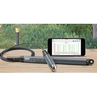
Things to Know When Choosing a Water Level Logger
. In addition to these questions, be sure to ask the manufacturer if the logger’s accuracy has been verified or measured against NIST-traceable standards. Some companies offer NIST-traceable calibration certificates as verification of the accuracy of each logger. 3. Software Features That Really Matter Just as water level loggers can vary considerably from model to model, so too can the graphing and analysis software or app that accompanies them. From a general standpoint, it’s a good idea to look for something that’s highly intuitive so that the learning curve
LR Senergy Unveils IP Software Suite
LR Senergy has released a new version of its formation evaluation and well data interpretation tool IPTM. The latest version of the software features enhancements to key workflows plus new technologies that make IP v4.3 the complete well data interpretation package for multi-user, multi-well and multi-discipline. The multi-user functionality offers safe and secure data connectivity through multi-user access (MUA), allowing for effective collaboration and fast decision making, while many of the IP workflows have been enhanced to have multi-well capability including a major upgrade to the
Kongsberg Mesotech Releases New M3 Sonar Software
Kongsberg Mesotech Ltd., a Kongsberg Maritime subsidiary, has released M3 Sonar Software V1.4 with a split-beam profiling mode and improved GeoTIFF export capabilities. Developed to support various applications, the new software features provide users expanded capabilities of the M3 Sonar in terms of application versatility and data interpretation. M3 Sonar Applications The new software features increase the capabilities of the M3 Sonar in various applications including: • Marine engineering • Site inspection