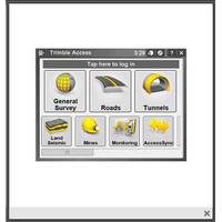
SonarMite Drivers Available for Trimble Access Field Software
Seafloor Systems announced the release of SonarMite drivers for Trimble Access Field Software. Seafloor’s SonarMite-MILSpec and SonarMite DFX singlebeam echosounders now work seamlessly with Trimble Access survey system. From GNSS, scanning, and optical technology for field data collection to powerful software programs for processing, modeling and analyzing captured data, Trimble offers complete solutions to address full work processes and unique challenges in the field.
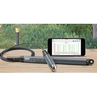
Things to Know When Choosing a Water Level Logger
water levels at multiple sites, it is often advantageous to be able to view and analyze data from each water level logger on a single graph. Be sure to ask the manufacturer about this capability. Easy data export – Because water level data often needs to be incorporated into other software programs, such as spreadsheets or modeling programs, make sure you’re able to quickly and easily export data in a range of data formats. Project save and recall – While the ability to save and recall projects may seem like a basic feature of any logger software package, the reality
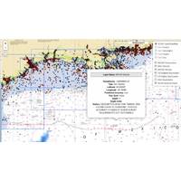
Coast Survey Improves Access to Wrecks Data
, making it easier for public users to view AWOIS data, by using freely available software such as Google Maps or Google Earth. Now, in addition to KML/KMZ and Microsoft Excel formats for general users, Coast Survey provides the data in ArcGIS REST services and OGC WMS services, for use in GIS software programs or web-based map mashup sites