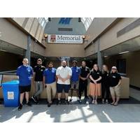
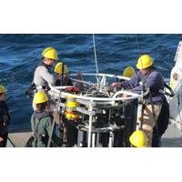
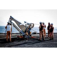
Students Spend Summer Mapping Seafloor for Seabed 2030
Mapping program of Memorial University, Canada. The mobilization was a collaborative effort among TCarta, Memorial University and The Nippon Foundation-GEBCO Seabed 2030 Project, which aims to inspire the complete mapping of the seafloor by 2030.The bathymetry was generated for the coastlines of Somalia, the Mosquito Coast, the Galapagos and the islands of the Lesser Antilles.During the summer, the students were introduced to a range of satellite imagery options and learned to evaluate the strengths of each for various project applications. TCarta provided training on using a pre-processing tool

UK Hydrographic Office Appoints Peter Sparkes as Chief Executive
work to improve the collection, standardization and sharing of marine geospatial data through international collaboration.Sparkes served in a wide variety of appointments in the Royal Navy, both at sea on operations and ashore. Notably, he commanded the frigate HMS Cumberland on counterpiracy patrol off Somalia and the U.K.’s Ice Patrol Ship, HMS Protector, in Antarctica. In addition to this, he commanded the 46 units (aircraft carriers, destroyers, frigates, mine-hunters, patrol vessels, and the maritime explosive ordinance disposal teams) of the Portsmouth Flotilla.Ashore, Sparkes has served in
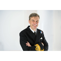
UKHO Appoints Rear Admiral Sparkes
that help UK Overseas Territories to create safe and sustainable blue economies.Sparkes joins the UKHO as a Rear Admiral in the Royal Navy. He has served previously in a wide variety of appointments, both at sea and ashore. Notably, he commanded the frigate HMS CUMBERLAND on counter-piracy patrol off Somalia and the UK’s Ice Patrol Ship, HMS PROTECTOR, in Antarctica. In addition to this, he commanded the 44 units (aircraft carriers, destroyers, frigates, mine-hunters, patrol vessels, and the maritime explosive ordnance disposal teams) of the Portsmouth Flotilla.Ashore, Peter Sparkes has served
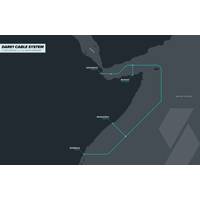
DARE1 Marine Survey, Somalia Landing Station Complete
Cable system with landing points in Djibouti, Somalia and Kenya will bring increased capacity and connectivity to East AfricaDjibouti Telecom, Somtel and SubCom announced that the marine survey for the Djibouti Africa Regional Express 1 (DARE1) submarine cable system has been completed and the cable route finalized. The companies also announced the addition of a landing station in Bosaso, Somalia. The DARE1 cable system is the first step in a planned expansion into eastern Africa, which will connect Djibouti (Djibouti), Bosaso (Somalia), Mogadishu (Somalia) and Mombasa (Kenya). With a finalized
Full-Depth Current Profiling Around the Global Ocean
.Farther north in the Indian Ocean, impressive oceanic changes follow the onset of the southwest monsoon. A well-known reversal of strong surface currents occurs in the Somali Current. Stacked jets of currents with opposing directions are found at depth. In addition, a large intense gyre spins up off Somalia over a month’s duration. Called the Great Whirl, the gyre reaches 500 km wide. It persists for three months and then dissipates as fast as it spun up.An impressive feature of the Great Whirl is its deep extent to 3000 m. US scientists collected LADCP data on two visits separated by 3 months
Drones Will Take Off for Shipping, Says Allianz
also be employed to carry out inspections at height, assess the structural integrity of a vessel or to monitor the loading of cargo.Drones will also have an increasing role in spotting and avoiding hazards at sea. EU NAVFOR’s anti-piracy naval mission has deployed drones to monitor the coast of Somalia and search for pirate activity.“In the future we will see drones used to avoid hazards at sea. For example, they could be used by ships sailing in Arctic and Baltic waters to identify ice and show the route ahead,” says Volker Dierks.If there is an incident, drones could also be used
Aerial Drone Scans for Pirates off Somalia
A team of antipiracy personnel currently on patrol off Somalia has deployed an unmanned aerial vehicle (UAV) to help scan for potential pirate activity in the region. As part of the counter-piracy military operation EU NAVFOR Somalia, also known as Operation Atalanta, the UAV crew from Spain’s 11th Squadron has been conducting air surveillance and reconnaissance patrols off the Somali coast using its ScanEagle drone from the deck of Spanish Navy ship ESPS Galicia. Once in the air, the five-foot-long UAV obtains images and video of maritime events in real-time, at night or
Spectrum in Somalia Seismic Pact
Spectrum ASA entered into a Multi-client master co-operation agreement with the federal government of Somalia during a signing ceremony on September 5th at the SYL Hotel, Mogadishu. The agreement allows Spectrum to acquire approximately 28,000 km of long offset 2D seismic data offshore south Somalia. The new acquisition has been specifically designed to complement 20,000 km of existing seismic that was acquired in 2014. Spectrum has also been granted the marketing rights for this data. Together, these seismic surveys will allow the in-depth study of hydrocarbon prospectivity offshore Somalia
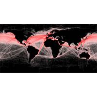
Study: Worldwide Ship Traffic up 300% since 1992
. The number of ships traversing the oceans grew by 60% between 1992 and 2002. Shipping traffic grew even faster during the second decade of the study, peaking at rate of increase of 10 percent per year in 2011. Traffic went up in every ocean during the 20 years of the study, except off the coast of Somalia, where increasing piracy has almost completely halted commercial shipping since 2006. In the Indian Ocean, where the world’s busiest shipping lanes are located, ship traffic grew by more than 300 percent over the 20-year period, according to the research. International trade and the sizes