Scientists Map Fast-moving Fault off Alaska
the risks from earthquakes and tsunamis that can occur when faults suddenly move.Since 2015, scientists have been gathering data on the Queen Charlotte-Fairweather fault system, a 746-mile long strike-slip fault line that extends from offshore of Vancouver Island, Canada, to the Fairweather Range of southeast Alaska. The team has gathered high-resolution bathymetric data through multibeam sonar across 5,792 square miles of the ocean bottom.The most recent survey came from NOAA Ship Fairweather, with USGS scientists aboard from April through July, when it collected multibeam bathymetric data in an area along
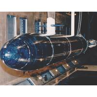
Navy Tests Scale Models in Big Facilities
to the Bahamas, and from Tennessee to Idaho.Carderock’s Combat Craft division in Little Creek, Va., manages a number of small craft projects to include design, construction, acquisition and sustainment.The South Tongue of the Ocean Acoustic Measurement Facility (STAFAC) in the Bahamas and the Southeast Alaska Acoustic Measurement Facility (SEAFAC) near Ketchikan, Alaska, feature underwater arrays to perform high fidelity passive acoustic signature measurements.Carderock’s Acoustic Research Detachment (ARD) is located far from the ocean in Idaho. Thanks to deep and quiet Lake Pend Oreille, the
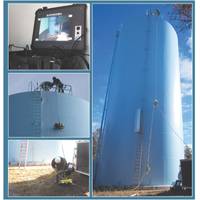
JW Fishers’ ROVs Used for Tank Inspection Services
and a Side Scan Sonar system. Alaska ROV Services are ready for hire to perform any underwater search or inspection and their goal is to service the entire state. Not only does Alaska have the most coast line in the entire country, it is also dotted with many lakes, bays, and rivers. Throughout Southeast Alaska there are an incredible number of commercial, charter, and sport vessels that use the entire “Inside Passage”. Alaska ROV Services are spreading the word to state troopers, search and rescue teams, university marine research departments, marine salvage and repair companies
Case Study: Mapping a Glacial Landslide
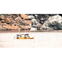
Remote Area Survey with the Z-Boat 1800RP Products: Z-Boat 1800RP Application: Remote Area Survey Project: Taan Fiord Landslide Assessment Customer: University of Washington Tacoma, Dr. Dan Shugar In October of 2015, a massive landslide was detected at Tyndall glacier in southeast Alaska, sending an estimated 145 million tons of valley wall into Taan Fiord. The landslide’s significant mass created a seismic signature that was detected by seismologists thousands of miles away at Columbia University in New York. Taan Fiord is an arm of Icy Bay in southeast Alaska. Over thousands
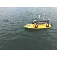
Z-Boat Shipped to University of Washington Tacoma
of Washington Tacoma included the Rugged Z-Boat 1800RP, Teledyne Odom Hydrographic MB2 Multibeam, Teledyne RD Instruments RiverPro ADCP, a camera, IMU and onboard computer. In early August, Shugar will head to Taan Fiord, an arm of Icy Bay in the rugged St Elias Mountains of southeast Alaska, to study one of the largest landslides in recent decades. The landslide partially covered the terminus of the tidewater Tyndall Glacier, releasing most of the debris into the fjord and triggering a massive tsunami. Shugar’s National Science Foundation-supported bathymetric mapping mission

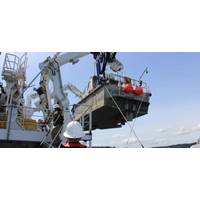
Coast Guard Helps Deploy Seismic Sensors in Southeast Alaska
sensors along the Queen Charlotte-Fairweather Fault, northwest of Craig, Alaska. The team placed the ocean-bottom seismometers along a 28-mile section of the Queen Charlotte-Fairweather Fault to improve understanding of recent earthquake activity and associated seismic and tsunami hazards in Southeast Alaska coastal communities. "The Queen Charlotte-Fairweather fault is similar to the northern San Andreas fault, with the same earthquake potential," said Dr. Peter Haeussler, a research geologist with the USGS. "A problem is that it is located entirely offshore, so it is much harder
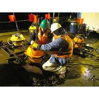
Subsea SE Alaska: Seismic Sensors Deployed
sensors along the Queen Charlotte-Fairweather Fault, northwest of Craig, Alaska. The team placed the ocean-bottom seismometers along a 28-mile section of the Queen Charlotte-Fairweather Fault to improve understanding of recent earthquake activity and associated seismic and tsunami hazards in Southeast Alaska coastal communities. “The Queen Charlotte-Fairweather fault is similar to the northern San Andreas fault, with the same earthquake potential,” said Dr. Peter Haeussler, a research geologist with the USGS. “A problem is that it is located entirely offshore, so it is much


