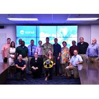
US Navy Taps Into Sofar Ocean's Data Buoy Network for Weather Forecasting
Research and Development Agreement (CRADA) to advance the U.S. Navy’s ocean weather forecasting and data collection capabilities. The organizations launched their strategic partnership at a joint knowledge sharing event on July 17-18 at Naval Oceanography’s headquarters at NASA’s Stennis Space Center.“CRADAs with partners like Sofar Ocean allow us to capitalize on the expertise between our organizations. Sofar’s technology contributes to the core capabilities of collecting accurate data and delivering at the speed and scale required to make the difference in operational warfighting
Getting to the Bottom of the Navies' Mine Warfare Challenges
or delayed.The Naval Research Laboratory (NRL) is a scientific and engineering command dedicated to research that drives innovative advances for the U.S. Navy and Marine Corps from the seafloor to space and in the information domain. NRL is located in Washington, D.C. with major field sites in Stennis Space Center, Mississippi; Key West, Florida; Monterey, California, and employs approximately 3,000 civilian scientists, engineers and support personnel.https://www.nrl.navy.mil/Penetrating problemMines laying on the seabed can be hard to detect among the clutter of rocks, seaweed and waste. “The
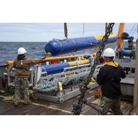
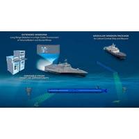
Subsea Defense: Navy Deepens Commitment to Underwater Vehicles
impacts a submarine’s buoyancy, or how sound travels underwater, or how storms form and intensify.Today, a third of those gliders are deployed operationally around the world at any given time, controlled by pilots at the Naval Oceanographic Office (NAVO) Glider Operations Center located at Stennis Space Center, Mississippi. The pilots communicate with the glider with Iridium satellite links to collect oceanographic data such as water temperature, salinity, water clarity and depth, and provide positioning and course instructions.Gliders can operate in remote locations for extended missions to collect
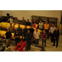
Unmanned Maritime Systems: Class in Session
unmanned systems.” The UMS program is made up of three tiers including novice, journeyman and expert levels. The inaugural class includes civilian and military personnel from the Naval Oceanographic Office, Fleet Survey Team and Naval Oceanography Mine Warfare Center based at Stennis Space Center; Naval Oceanography Special Warfare Center based in San Diego; Submarine Development Squadron 5 based in Bangor, Wash.; Naval Undersea Warfare Center based in Newport, R.I.; and the National Oceanic and Atmospheric Administration (NOAA) in based in Norfolk, Va. USM School of Ocean
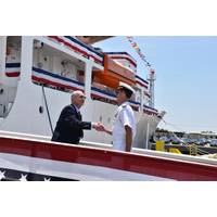
US Navy's New Oceanographic Vessel Sets Sail
previous T-AGS design to accommodate a moon pool used for launch and recovery of AUVs and other oceanographic systems. Maury is operated by Military Sealift Command (MSC) and is technically controlled by NAVOCEANO for Commander, Naval Meteorology and Oceanography Command based at Stennis Space Center in southern Mississippi
New Lineup for NOAA Hydrographic Services Panel
on commercial maritime needs and hydrographic data that is tremendously valuable to us as we work to build resilient communities and businesses along our nation’s coasts.” The new and reappointed members join current members: Rear Admiral Ken Barbor (ret.), U.S. Navy, Stennis Space Center, Mississippi Lawson W. Brigham, Ph.D., University of Alaska at Fairbanks Capt. Deborah Dempsey, Columbia River Bar Pilots, Bellingham, Washington Rear Admiral Evelyn Fields (ret.), NOAA Corps, Germantown, Maryland William Hanson, Great Lakes Dredge & Dock Company, Oak
Blue Tech Economic Engine Shifts into High Gear
U.S. Small Business Administration announced on Sept. 30 that it was supporting a new regional innovation clusters, to include a Marine Industries Science and Technology (MIST) cluster along I-10 Corridor including Louisiana, Mississippi, Alabama, and Florida. The MIST cluster will focus on the Stennis Space Center’s ecosystem of world class marine technology research, the highest concentration of oceanographers in the world, and a broad consortium of federal and state partners to provide targeted support for the creation and growth of small businesses involved in “blue technology.&rdquo
USCG, NOAA Place Weather Buoy off California
“3D69/46012”, the 3,500 pound, 18 feet high by 9 feet wide weather buoy is designed to measure wind speed, air and water temperatures, barometric pressure, and wave height and periods. The data, collected by sensors located on the inside and top of the buoy, is transmitted to the Stennis Space Center in Mississippi for publication on its website. Earlier this year, the weather buoy had ceased transmitting weather data. “Fishermen complained to local congressmen about the lack of information for weather conditions in the area,” said Lt. Cmdr. Dan Twomey, assigned to
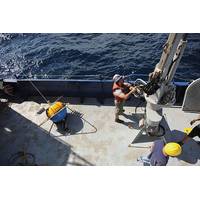
Exocetus Glider Passes Shallow Water Tests
for environmental monitoring in coastal waters with currents in excess of 1 meter/second and can operate in waters with large density variations due to the Exocetus patented adaptive ballasting control system. With the support of the University of Southern Mississippi [USM] staff at the Stennis Space Center, glider tests were conducted in the Pearl River on November 20, 2013, where water depths vary from 1-5 meters. The Exocetus Coastal Glider operated in both upstream and downstream water conditions. The Exocetus Glider was surprisingly able to successfully complete 180 degree turns in waters