Marine Technology News Search
Search term • "advanced navigation"
Create an email alert for "advanced navigation"

"AI is the Game Changer"
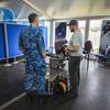
Austal USA Advanced Technologies is working with the US Navy on technical solutions that will power the next-gen of navy assets. Don Hairston recently took the helm of the AAT team, and discusses how additive manufacturing and artificial intelligence are powering the future of naval asset design, construction and lifecycle maintenance.Don, what specifically attracted you to the position as GM of Austal USA Advanced Technologies?I liked Austal USA as an up-and-comer…

Schmidt Sciences Awards $33m for Global Freshwater Research
Four international teams of researchers will receive $33 million from Schmidt Sciences over five years to advance the global understanding of freshwater availability through the Virtual Institute for Earth’s Water (VIEW). Their research will leverage AI and high-resolution data to build a first-of-its-kind "global water ledger"—a definitive account of the world's freshwater resources to inform more effective…

Quantum Sensing Beats GPS-Denied Navigational Challenges
The same error-prone sensitivity that has slowed down the development of quantum computers is being turned into an advantage for GPS-denied navigation.A new quantum sensing technology from Australia-based Q-CTRL has most recently caught the interest of Lockheed Martin and the US Defense Innovation Unit, but the company is already working with the Australian Department of Defence, the UK Royal Navy…
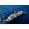
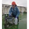
Oceaneering Upgrades Survey Vessel for Simultaneous Autonomous Missions
U.S.-based subsea services and technology firm Oceaneering has completed a major upgrade of its Ocean Intervention II oceanographic research vessel, equipping it to perform simultaneous autonomous offshore survey missions.The retrofit, carried out in early 2025 on the 25-year-old vessel, has made it capable of launching and recovering both uncrewed surface vehicles (USVs) and autonomous underwater vehicles (AUVs).The vessel…

Fincantieri, PGZ Join Forces for Modernization of Polish Navy
Italian shipbuilder Fincantieri and Polska Grupa Zbrojeniowa (PGZ), Polish state-owned defense group, have signed a memorandum of understanding (MoU) to co-operate on the modernization of Polish Navy and explore opportunities in wider naval defense market.The MoU establishes a framework for strategic collaboration aimed at supporting the modernization of the Polish Navy, with a particular focus on the ORKA submarine acquisition program.Under the agreement…
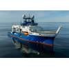
Schmidt Ocean Institute Advances R/V Falkor (too)’s Mapping Capabilities
Schmidt Ocean Institute announced it has mapped two million square kilometers of seafloor — about the size of Greenland — and this year, has made two significant changes to advance the seafloor mapping capabilities of R/V Falkor (too): it changed the shape of the ship’s bow and added an Autonomous Underwater Vehicle (AUV) to its technology suite.Over a two-month dry dock period (April 28–June 28) in Talcahuano…
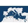
Nokia to Power Medusa Submarine Cable System Between Europe and North Africa
Nokia announced that it will power the Medusa Submarine Cable System, a project owned by AFR-IX Telecom. The new subsea fiber-optic network will connect the Atlantic coast, Mediterranean Sea and the Red Sea, creating a new high-capacity digital corridor in the region, driving connectivity, innovation, and economic growth across the region.The Medusa subsea cable is a significant step toward closing the digital divide between Europe and North Africa…
Coast Guard Establishes Robotics Office
The U.S. Coast Guard has set up the initial operating capability of a Robotics and Autonomous Systems Program Executive Office.The office is a key component of the Service's Force Design 2028 (FD 2028) plan, and the Coast Guard claims it is poised to be the most transformational enhancement to capability since the inception of aviation. The office is dedicated to the rapid operationalization of the…
Blueye Robotics to Deliver ROVs to the Netherlands Royal Navy
Blueye Robotics, together with local partner RVI Tools, has secured a major international contract to supply underwater remotely operated vehicles (ROVs) to the Netherlands Royal Navy.The ROV systems will be delivered with advanced capabilities tailored for military engineers and mine countermeasure (MCM) teams.The awarded contract highlights the increasing demand for compact, user-friendly underwater systems to support complex military operations in inshore and coastal environments.
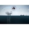
Aker Solutions, Kongsberg Discovery Partner on Offshore Drone Detection
Aker Solutions and Kongsberg Discovery have teamed up to deploy a drone detection system aimed at protecting offshore infrastructure, beginning with a demonstrator at Aker Solutions’ site in Stavanger.The system uses Kongsberg’s Drone Detection Radar and is part of a broader plan to roll out surveillance technologies across the North Sea to bolster situational awareness around energy assets and transit lanes.Kongsberg Discovery develops navigation…

STAPEM Ops for Sonardyne’s Precise Positioning System
France-based STAPEM Group has chosen Sonardyne’s Ranger 2 Ultra-Short BaseLine (USBL) technology as the permanent solution for one of its flagship offshore support vessels, the STAPEM Boreale.Operating in one of STAPEM Group’s key regions, Angola, the vessel is now equipped with a Ranger 2 GyroUSBL 7000 system, an all-in-one, high-performance USBL system for precise positioning performance, previously used on a hire basis.Ranger 2 GyroUSBL 7000 is optimized for ultra-deepwater operations and…
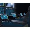
FET Launches Remote Control Station for Subsea ROV Operations
Forum Energy Technologies (FET) has introduced a new remote control station designed to allow remotely operated vehicle (ROV) systems to be operated from any location.The system operates using the ICE Unity ROV control platform released in 2025 and enables remote operations, live streaming of survey data and monitoring of ROV systems.The package includes FET Subsea advanced control chairs, Remote-Connect gateway enclosures and VisualSoft’s video streaming and network player technology.
BIRNS Achieves AS9100:2016 Certification
BIRNS, Inc., designer and manufacturer of high performance connectors, custom cable assemblies and lighting systems, has announced that its Quality Management System (QMS) has been certified to AS9100:2016 ( Rev.

MBARI Names Antje Boetius President and CEO
Prominent deep-sea polar biologist Antje Boetius will take over as president and CEO of MBARI, a private, non-profit oceanographic research center in Moss Landing, Calif. Boetius, who has garnered international acclaim for her work, will assume her role on May 1, 2025, succeeding the retiring Chris Scholin.Boetius joins MBARI after a seven-year tenure as director of the Alfred Wegener Institute for Polar and Marine Research in Germany.
UK NOC's Study Challenges Role of Plankton in Ocean Carbon Storage Process
A new UK National Oceanography Centre (NOC)-led study has put a major question mark over the role a unique group of tiny microscopic plants plays in driving ocean carbon storage.Diatoms, a type of plankton or marine algae, have a significant role in drawing carbon down into the deep, especially in the Southern Ocean, which takes up about a third of organic carbon stored in the ocean.Uniquely, diatoms have dense…

The Week the Arctic Slipped South
With powerful winter storms, it’s easy to focus on what’s happening at the surface: snowfall totals, wind chills, and travel impacts. But the real story often begins thousands of miles away, high in the atmosphere, long before the first flakes ever fall.In March 2026, a major winter storm swept across the Midwest United States, and it didn’t start with snow or wind at all. It started with a subtle shift far to the north…
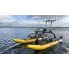
OPT Reports $1.25 Million on WAM-V USV Orders
Ocean Power Technologies (OPT) announced it has received multiple orders for fully integrated WAM-V uncrewed surface vehicles (USV) totaling over $1.25 million.The recent commercial orders come from clients in Latin America, the company said without naming the customers."These orders underscore the growing demand for OPT's advanced marine technologies and their applications in maritime surveillance…
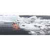
University of Gothenburg to Buy New AUV
The University of Gothenburg will buy a new underwater vehicle to replace Ran, the AUV that was lost under a glacier in Antarctica in 2024.A large donation means that researchers can plan for new expeditions.The autonomous underwater vehicle (AUV) Ran contributed to groundbreaking research, education and technological development for six years. The most groundbreaking results were achieved during risky missions under the floating glaciers of Antarctica.

NASA and bp Collaborate on Space and Subsea Visualization Technology
bp America has signed an agreement with NASA to support common goals in space exploration and energy production.The Space Act Agreement will drive collaboration on a variety of technologies, such as digital models and simulations that allow engineers and scientists to visualize equipment in remote locations more than 7,000 feet underwater or millions of miles away on another planet.The initial phase…
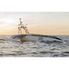
IMAS Technology Mitigates Risks for USVs
Once a niche technology, Unmanned Surface Vessels (USVs) are at the center of a transformation in the maritime industry. From offshore surveying and environmental monitoring to defense operations, USVs offer compelling advantages in efficiency, cost reduction, and human safety. However, as these autonomous and remotely operated vessels become more prevalent in our oceans and waterways, they bring unique…