TCarta Plans Bathymetric Mapping Workshop for Jamaica
of February 5, 2024, at the NLA Surveys & Mapping Division headquarters in Kingston, Jamaica, the workshop will instruct participants in the use of satellite-derived bathymetry (SDB) technology with the TCarta Trident Geoprocessing Toolbox. The software-as-a-service SDB Toolbox operates within Esri ArcGIS Pro and enables users to perform their own extraction of bathymetric measurements from satellite, aerial, and UAV imagery.“TCarta greatly appreciates Seabed 2030’s continuing commitment to expand hydrographic mapping education around the world,” said TCarta President Kyle Goodrich
Greensea Announces Software Upgrades, VideoRay Partnership
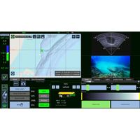
on OPENSEA, are open architecture and support the future generation of ocean robotics through navigation, autonomy, and advanced user interface concepts, including remote and over-the-horizon supervision.EOD Workspace 6.3 represents a major update to the previous version – including support for ArcGIS and a user interface redesign to support VideoRay’s Expeditionary Splashproof Controller. The user interface redesign is the culmination of hours of interviews and more than two years of trials with EOD Technicians to ensure user interactions with the software are more intuitive and natural
Mapping the Future
Data group during Round 1 overseeing the logistics of the group and the development of the data workflow.Can you describe some of the data processes you are using to enable GEBCO-NF to reach its aims of mapping the world’s oceans?We are using existing software such as CARIS HIPS & SIPS and ESRI ArcGIS. The main goal of the Data team is to make our workflow as autonomous as possible and to reduce processing time. When we put an aim such as mapping the world’s ocean the first thing is to develop equipment, however, then we are facing another big challenge – how to efficiently process
The Price of Subsea Mining
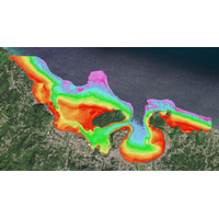
by purple tracklines labelled with the dive number (e.g. AV01). Stations where imagery was collected with a baited camera (CA02, CA06, CA07, CA08, CA09) and samples collected with a baited trap (TR08) are also indicated. All maps were created by Seafloor Investigations Ltd for the ABYSSLINE Project using ArcGIS software. (As published in the October 2017 edition of Marine Technology Reporter
Drones: The Next Great Leap in Hydrography
data. And thanks to new innovations in drone technology, maritime users can exploit that integration in new and exciting ways. A seamless topobathymetric surface is now available to hydrographers interested in a more efficient and economical workflow. Esri has just released the Drone2Map for ArcGIS app, which transforms high-resolution drone imagery into ready-to-use aerial data in the GIS platform. Users can bring point-clouds, mosaic datasets, 3D meshes and orthomosaics directly into the platform in near real time without any third-party application. This is a huge leap in hydrographic technology
Cegal Debuts Blueback Seismic Data Management
third party tools to produce custom reporting and dashboards,” says Ketil Waagbø, Software Portfolio Manager in Cegal. The solution integrates with geographical information systems (GIS) and provides map and table based views. The spatial information can be accessed directly from ESRI ArcGIS for integration into GIS workflows and external maps.
BioSonics Upgrades Aquatic Habitat Mapping Software
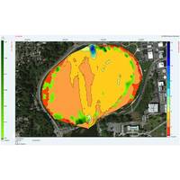
with bathymetric contours. VH2 allows users to interpolate and form gridded data using three different methods: Triangulated Linear Interpolation, Inverse Distance Weighting and Ordinary Kriging. Users can print maps directly or export results as KML, shapefile or image files for use in Google Earth or ArcGIS. VH2 also automatically computes grid statistics including the area, water volume and plant and volume. Existing users can download VH2 at no cost and a demo version is available for new users. BioSonics President Tim Acker explained, “The release of VH2 software provides the missing
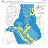
Play Fairway Mapping is Key in the North Sea
to assess the remaining prospectivity of the large number of North Sea plays with proven hydrocarbons, and to locate new resources in areas of poorly understood geology and limited exploration.” The Ternan report is published as a digital atlas with an accompanying well database and ArcGIS project. The digital atlas contains more than 160 maps and figures, illustrating the interpretation that builds into a complete picture of the play fairway of each of the 19 plays in the region. The well database is available as either an ODMTM project or MS Access database. The data
MTR 100: QPS
2012 QPS became a member of the SAAB (Sweden) group of companies (Security and Defence Solutions). Quality Positioning Services (QPS) makes industry leading software for collection, post processing and visualization of maritime geomatic data. Its products QPS QINSy and QPS Fledermaus seamlessly partner ArcGIS for Maritime, to solve problems and gain efficiencies for maritime related survey business. Our product QPS Qastor is an Electronic Chart Software (ECS) that enables navigation, piloting and precise docking, as well as several other application such as Oil & Gas FPSO/SPM mooring, patrol vessel