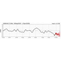
The Week the Arctic Slipped South
begins thousands of miles away, high in the atmosphere, long before the first flakes ever fall.In March 2026, a major winter storm swept across the Midwest United States, and it didn’t start with snow or wind at all. It started with a subtle shift far to the north, where the atmosphere over the Arctic began to lose its usual structure and stability, setting off a chain reaction that would eventually reshape weather across much of the United States.Meteorologists watching the larger-scale patterns could see it developing days in advance, as the Arctic Oscillation shifted deeper into its negative
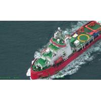
Coast Guard Responds to Increased Chinese Research Vessel Activity in Arctic
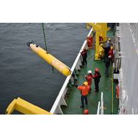
The U.S. Coast Guard has detected two Chinese research vessels operating in the U.S. Arctic and is currently monitoring five similar vessels in or near the U.S Arctic.On August 5, a C-130J Hercules fixed wing aircraft from Air Station Kodiak responded to the Chinese research vessels Ji Di and the Zhong Shan Da Xue Ji Di. Both vessels were transiting northeast in the Bering Sea.On August 6, the crew of U.S. Coast Guard Cutter Waesche (WMSL 751) again responded to the Zhong Shan Da Xue Ji Di as it was transiting north in the Chukchi Sea above the Arctic Circle, after passing through the Bering
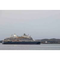
North Pole Marathon Offers Forum for Climate Change Science Aboard Icebreaker
The North Pole marathon concluded on July 13 this year but the annual race on the world’s northernmost point is also a scientific expedition to battle climate change in the Arctic.The North Pole Forum, a scientific initiative by the marathon organiser Runbuk, offered the runners an opportunity to learn more about the North Pole’s ice sheets, the challenges around the region’s preservation and development.The Forum played out as a series of talks by global Arctic experts aboard the French icebreaker cruise ship Le Commandant Charcot that carried the runners both to and from the North
Coming in from the Cold: Canadian Arctic Security Takes Center Stage
More than 75% of Canada’s world-leading coastline (upwards of 150,000 miles or 240,000 kilometers) is Arctic, along with roughly 40% of the land. Geopolitical instability, mixed with strained relations with the United States, a rapidly warming climate and constant technological advancement have heightened northern security concerns, especially for a nation so intertwined with Arctic ecosystems and communities.Warm Weather, Frosty RelationsAlthough challenges to Arctic security are not singular to Canada, they are numerous and complex, requiring multifaceted solutions. “The Arctic has
MBARI Research Supports Cryospheric Science
Decade of Action for Cryospheric Sciences, an international initiative focused on the rapid changes occurring in glaciers, snow cover, ice sheets, sea ice, and permafrost and their impacts on the planet.MBARI’s research and technology will play a critical role by providing important data about the Arctic seafloor and the Southern Ocean.“Ice-covered ocean and land are integral to the health of our planet and host unique communities of life. The Decade of Action for Cryospheric Sciences provides an opportunity to collaborate to better understand and protect these critically important polar environment
Naturally Quiet
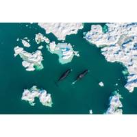
The Arctic’s bowhead whales can live for over 200 years. Imagine what they might hear in that time: screw propellers were only just being used to power ships 200 years ago, and diesel engines appeared some hundred years after that.The underwater radiated noise of shipping has grown globally, but the Arctic is a special place. It has been partially shielded from shipping noise. Sea ice shields and diffuses underwater sound, so belugas and narwhals, for example, can find shipping noise particularly disturbing – perhaps leaving the area for days. There have been reports of belugas
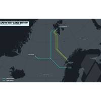
Space Norway, SubCom Announce Contract-in-Force for Arctic Way Cable System
Space Norway and SubCom announced that a contract is in-force for the survey, design, supply and installation of the Arctic Way Cable System. Providing necessary route diversity to a region with rapidly increasing data traffic demands, the new system will become a critical asset for transmitting data between the Norwegian mainland, Jan Mayen, and the Svalbard archipelago.SubCom will produce the components for Arctic Way at its manufacturing campus in Newington, NH, USA. The trunk-and-branch, repeatered system will be approximately 2,350 km in length with direct shore end landings in Bodø, Norway
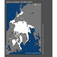
Arctic Sea Ice Hits Record Low Maximum Extent for the Year
Arctic sea ice has likely reached its maximum extent for the year, at 14.33 million square kilometers (5.53 million square miles) on March 22, according to scientists at the National Snow and Ice Data Center (NSIDC) at the University of Colorado Boulder.The 2025 maximum sea ice extent is the lowest in the 47-year satellite record, falling short of the previous record low of 14.41 million square kilometers (5.56 million square miles) set on March 7, 2017.“This new record low is yet another indicator of how Arctic sea ice has fundamentally changed from earlier decades,” said NSIDC senior
MoU Signed for Pan-Arctic Cable System
Cinia Oy, NORDUnet A/S, Tusass A/S, the Dutch Subsea Cable Coalition, GlobalConnect AB, and Tampnet A/S have signed a European Memorandum of Understanding (MoU), recognizing the strategic value of a Pan-Arctic Cable System (PACS) and the contribution such a cable system will make to the global digital connectivity infrastructure.The MoU affirms the partners’ vested interests in establishing and executing a long-term strategy for jointly realizing the development and implementation of a pan-Arctic submarine cable system.Polar Connect is a proposed subsea cable on a direct route east of Greenland


