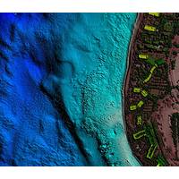
Fugro Advances Bathymetric Lidar Mapping Capabilities
and point densities for nearshore and coastal mapping. Known as RAMMS (Rapid Airborne Multibeam Mapping System), the field-proven technology promises to deliver an efficient and cost-effective solution, dramatically improving upon other bathymetric lidar mapping capabilities.“Traditional bathymetric lidar technology requires customers to compromise between price, depth penetration and data density,” said Ed Saade, president of Fugro USA and regional director for Fugro’s Marine Division in the Americas. “With RAMMS, there’s no trade-off. It can achieve 3-Secchi disk depth penetration
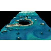
Coastal Mapping Tech in Focus at Shallow Survey
aircraft. The presentation “A look into the performance of bathymetric lidar systems” will be given by Chris Macon of the Joint Airborne Lidar Bathymetry Technical Center of Expertise (JALBTCX). JALBTCX and Teledyne Optech have worked together for 25 years to advance bathymetric lidar technology, resulting in CZMIL’s advanced capabilities. JALBTCX spent the summer testing several types of bathymetric lidar sensors, and Macon will discuss their results. Teledyne Optech exhibit examples of bathymetry work from CZMIL in turbid water in Asia and Lake Michigan, where
Fugro Set for Southwest Pacific Survey
Fugro has commissioned an additional airborne laser bathymetry system to underpin its position in the development and application of bathymetric LiDAR technology. The combined Fugro LADS Mk 3 and Riegl VQ-820-G systems provide measurements and mapping of nearshore and shallow water environments. The increased capability will enable Fugro to deliver simultaneous topographic and bathymetric surveys in multiple geographical areas. With continued operations across the Middle East during 2015, Fugro will also begin a South West Pacific ALB survey campaign following the award of projects in multiple