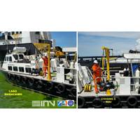
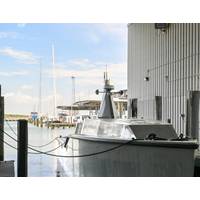
Smaller Footprint, Broader Missions: How CHASING ROVs Expand Subsea Inspection Capabilities
for this operating space. Founded in 2016, its professional portfolio includes the CHASING X industrial ROV and the more compact CHASING M2 PRO MAX.The two platforms address different deployment requirements, but follow the same principle: the ROV provides underwater mobility, control, power and communications, while accessories are selected according to the environment, target and required deliverables.For missions requiring greater range, stability and multi-sensor integration, CHASING X is rated to 350 meters and designed to resist currents of up to 4.5 knots. Its low-light 4K camera, 12,000-lumen
Nauticus Robotics Seeks Ocean Sensing Opportunities with Aquanaut Platform
continuous streams of environmental and geophysical data while enabling greater visibility into changing ocean conditions and critical subsea assets.The world's oceans remain significantly under-sensored despite their increasing importance to environmental stewardship, offshore energy, subsea communications, scientific research, national security, and critical infrastructure protection. This presents an opportunity for autonomous subsea robotics to support the deployment and long-term operation of continuous ocean sensing infrastructure, creating a new class of persistent underwater monitoring capabiliti
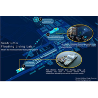
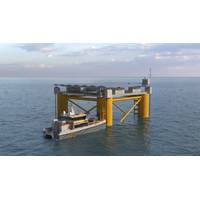
Seatrium Powers First Electricity Export to Singapore Grid from Floating Platform
role as an integrated and scalable energy solution.In addition, the FLL has achieved the Remote-CON notation from ABS, validating its remote-control capabilities for power generation and controls from an onshore command centre. The notation recognizes the integration of advanced automation, secure communications and control system architecture, enabling key onboard systems to be operated remotely while meeting stringent safety and redundancy standards.To further scale these capabilities, Seatrium has operationalized a ROC built on DNV's assurance frameworks, integrating secure communications, data
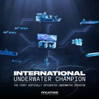
Fincantieri Strikes Four Deals in $687M Underwater Expansion
Italian shipbuilder Fincantieri has agreed to acquire majority stakes in four companies for an initial expenditure of about $687 million (€600 million), expanding its capabilities in marine drones, subsea services and underwater communications across commercial and defense markets.The agreements cover acquisitions of majority stakes in Next Geosolutions, WSense, Graal Tech, and Defcomm, which will be integrated into Fincantieri’s Underwater technological hub.Next Geosolutions, listed on Euronext Growth Milan, provides marine survey and geoscience services as well as offshore construction
52-ft. ASV 'Mirage' Splashes
Saronic’s family of vessels. The 52-ft. ASV runs on the same core autonomy stack that Saronic has developed and validated through its other vessels. Passive perception and collaborative autonomy capabilities — including navigation, tracking, and detection — are enabled by redundant communications and intuitive control interfaces. Its open, modular architecture enables rapid integration of a wide range of Government-Off-The-Shelf (GOTS) and Commercial-Off-The-Shelf (COTS) hardware and software solutions, including mission payloads, sensor packages, and command-and-control systems, without
OMS Group Completes USV Training Program
step towards commercial deployment of USV Elite.The training brought together OMS’s USV pilots, remote survey specialists and field technicians for an intensive program covering both operational execution and technical proficiency. Sessions included advanced piloting and mission management, communications and connectivity resilience, mechanical and electronic engineering fundamentals, survey data acquisition workflows, and structured emergency response procedures.OMS emphasized that its operating model is grounded in professional maritime competence. USV Elite is operated by certified seafarers
Dutch Grant Backs SolarDuck's Offshore Solar Power Hub Scheme
floating platform designed to provide power and utilities to remote subsea assets.The funding will support the Steady Seas research program, which aims to develop SolarDuck's Offshore Floating Power & Utility Hub (OFPH), a single-platform offshore solar solution intended to provide power, communications and other utilities to offshore and subsea infrastructure.The companies said the platform is designed as an alternative to long subsea cables, umbilicals and diesel-powered local generation systems that are often used to support remote offshore assets.According to SolarDuck, the OFPH will generate

SolarDuck, MARIN Awarded $3.6m to Advance Offshore Floating Power Hub
;3.2 million) subsidy from the Netherlands Enterprise Agency (RVO) for the Steady Seas research program. The project will advance the foundational design of SolarDuck's Offshore Floating Power & Utility Hub (OFPH), a single-platform offshore solar solution developed to provide reliable power, communications and other utilities to remote offshore and subsea assets.As offshore energy activity moves further from shore, the need for reliable in-field power is becoming increasingly important. Subsea oil and gas infrastructure, Carbon Capture and Storage (CCS) projects, offshore monitoring systems and
KONGSBERG Delivers Vessel Traffic Services Solution to Great Belt VTS
the Danish Armed Forces and the Danish Emergency Management Agency.Great Belt VTS operates in a uniquely complex environment. With safety and security at the forefront, the solution has been designed to meet strict operational needs and requirements, including high availability, redundancy and secure communications.KONGSBERG has delivered Foresight, our in-house developed family of software systems for maritime domain awareness, including special adaptations and development tailored to Great Belt VTS’ needs. The solution is integrated with existing radar and CCTV infrastructure, with KONGSBERG holding


