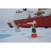
US Coast Guard Cutter Healy, Scientists Deploy Ice Stations
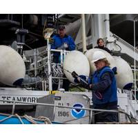
U.S. Coast Guard Cutter Healy (WAGB 20) crew and embarked researchers ventured onto a floe of multi-year ice for the first of three multi-instrument ice stations in the Arctic Ocean Basin late July and early August.As the Healy carefully approached and maintained position alongside an ice floe above 77 degrees north, the crew and a team of scientists, working in cooperation with the Office of Naval Research, (ONR) offloaded a diverse collection of equipment on to the floe carefully selected for its size and composition of multi-year ice.The objectives included the installation of two major instruments:
#Oi2020: Subsea History
and Ocean Mapping (and his team at the center), worked closely with the U.S. Coast Guard (USCG) to gain access to a platform capable of breaking and transiting through ice, while also supporting the scientific equipment needed to gather data on the extended continental shelf (ECS). The Coast Guard Cutter Healy was tasked with the job, and during Mayer’s first outing with the vessel that year he and his team discovered a 10,000-foot high seamount approximately 400 miles north of Barrow, Alaska, which they named the Healy Seamount.Thirteen years later, On September 23, 2016, (see photo) the Healy&rsquo
'Roomba' in the Arctic
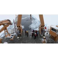
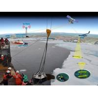
maritime activity in the region increases. To be ready, the U.S. Coast Guard places a high priority on developing options for recovering oil in the Arctic. To that end, an important research project took place this August during the Coast Guard’s annual science patrol aboard the cutter Healy, the United States’ newest and most technologically advanced polar icebreaker. Arctic West Summer 1701 ‘Arctic West Summer 1701’ started July 20 and concluded August 17 when the Healy returned to Seward, Alaska. The research agenda was extensive, including autonomous
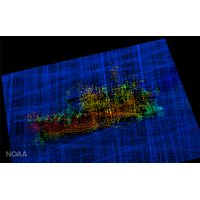
Crab Fishing Vessel Wreck Found off Alaska
on July 8 and 9. The Fairweather used its multibeam sonar, designed for seafloor mapping and object detection, to locate the Destination in approximately 250 feet of water. With the wreckage and debris field located by NOAA ships, a U.S. Coast Guard dive team aboard Coast Guard Cutter Healy will use a remotely operated vehicle to investigate the wreckage later this month. Imagery from the ROV will provide visual confirmation of the wreck site and become part of the Coast Guard’s Marine Board of Investigation, which holds its public hearing August 7-18 in Seattle.
NOAA Deploys Survey Ships for Arctic Charting Projects
, NOAA’s hydrographic project areas for Alaska cover 2,800 square nautical miles, plus the 12,000 linear nautical miles for the shipping route project. Coast Survey will use the data collected by the NOAA ships and TerraSond, as well as depth measurements taken by U.S. Coast Guard Cutter Healy, to update its navigational charts, as laid out in its Arctic Nautical Charting Plan. The marine corridor project will also provide information to help the Coast Guard assess the safety of the proposed USCG port access route. NOAA’s Office of Coast Survey, originally formed by President
NOAA to Boost Arctic Nautical Charting
Bering Strait As commercial shipping traffic increases in the Arctic, NOAA informs it is taking steps to update nautical charts in the region. NOAA’s Office of Coast Survey will use data collected by two of its own ships, Rainier and Fairweather, as well as the U.S. Coast Guard cutter Healy and a private sector hydrographic contractor to cover nearly 12,000 nautical miles in the Arctic for use in updating its navigational charts. The NOAA-led Arctic marine corridor project will work with the Coast Guard to assess the safety of a potential Arctic shipping route from Unimak
Scientific Team Arctic-bound Aboard Cutter 'Healy'
A team of scientists from the Coast Guard Research and Development Center (RDC) is to depart shortly from Seward, Alaska, for a technology evaluation in the Arctic aboard the Cutter 'Healy informs USCG. The RDC is leading a multi-agency team to support Arctic Shield 2014, a 17th Coast Guard District initiative. The purpose of their month-long evaluation is to improve Coast Guard capabilities in the Arctic region, specifically in the areas of boat operations, communications, navigational safety and oil spill response. “The RDC plays a key role in charting the service’s future efforts
Research Conglomerate Collects Arctic Ocean Data
Crewmembers aboard Coast Guard Cutter Healy recently supported scientific research in the Arctic’s dynamic waters. As the crew supported vital scientific research, they were joined by a multitude of scientists and support staff from the National Intelligence University, U.S. National Oceanic and Atmospheric Administration, U.S. Air Force, Woods Hole Oceanographic Institution and University of Alaska. Dr. Peter Leitner, a professor and faculty member at the National Intelligence University, was aboard the red-hulled Healy and braved Arctic temperatures to understand the effects of extreme
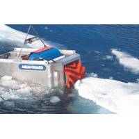
Coast Guard to Test Arctic Oil Spill Technologies
Center (RDC) plans to test and evaluate oil spill detection and recovery technologies in the Arctic Ocean as part of Operation Arctic Shield 2013. A multi-agency team of engineers and scientists led by RDC researchers will conduct a series of demonstrations in September 2013 aboard Coast Guard Cutter Healy to test and evaluate capabilities of various unmanned aerial systems (UAS), an unmanned underwater vehicle (UUV) and a remotely operated vehicle (ROV) to search for simulated oil spills. To support planned UAS testing, the RDC has assembled a team to include National Oceanographic and Atmospheric