Global Reef Expedition: Mission to Tonga
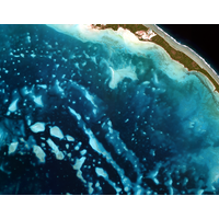
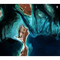
reef ecosystem.©Khaled bin Sultan Living Oceans Foundation/Ken MarksMapping the ReefThe most novel aspect of the study was the creation of high-resolution habitat and bathymetric maps of Ha’apai, Vava’u, Niuatoputapu. Using multispectral WorldView-2 satellite imagery obtained from DigitalGlobe Inc., in combination with data obtained from aerial surveys and ground-truthing, we created high-resolution maps of the shallow marine environments in Tonga. These maps have been shared with government officials in Tonga and are available to explore on the Khaled bin Sultan Living Oceans Foundation
UKHO Contracts with TCarta
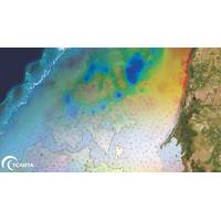
is threatened by rising sea levels.TCarta won the open bid for supply of Satellite Derived Bathymetry (SDB) to the UKHO to extract water depth measurements and seafloor classifications, including habitat types, from multispectral satellite imagery. In this project, TCarta is processing eight-band DigitalGlobe WorldView-2 and -3 data predominantly, as well as four-band WorldView-4 and GeoEye-1 data to measure depths down to 30 meters at a resolution of two meters.The Kiribati nation is comprised of 33 atoll islands and multiple reefs spread over an area of the Pacific Ocean nearly the size of the Continental
NSF Grant to Enhance Satellite-derived Bathymetry Technology
scope of SDB in shallow coastal areas,” said Kyle Goodrich, TCarta President. “SDB technology currently derives water depths only in calm, clear waters, which limits its applicability.”TCarta won the grant for Project Trident in partnership with jOmegak of San Carlos, Calif., and DigitalGlobe of Westminster, Colo., in Phase 1 of the NSF Small Business Innovation Research program. The one-year research project will be carried out at the TCarta facility in Denver.In 2014, TCarta successfully commercialized a proprietary technique for digitally extracting water depth measurements down
MG3 & Satellite Derived Bathymetry
even a few meters below the surface.Deriving Water DepthTCarta commercialized the proprietary technique to extract water depth measurements from satellite imagery and now creates the products. During production, TCarta processes eight-band high-resolution multispectral imagery captured by the DigitalGlobe WorldView satellites over coastal zones. The processing derives seafloor depths with an accuracy of two meters to a depth of about 20 meters. TCarta applies rigorous quality control to ensure data accuracy.“The satellite derived process is more cost-effective than airborne or shipborne methods

Oceanology International 2014 Exhibitors
Technology PACIFIC CREST Panolin Parkburn Precision Handling Systems Ltd Parker Maritime AS PDM Neptec Ltd Pearson Engineering Services Periplus Group Planet Ocean Ltd PMI Industries, Inc. Pole Mer Méditerranée Positioneering Limited Prevco Europe LLC Proteus FZC and DigitalGlobe QPS BV Qualitas Remos R2 Sonic LLC Radac B.V. RBR Ltd Remote Ocean System RIEGL Laser Measurement Systems GmbH RJE International Inc. Roaming Expert Rolls-Royce Canada Limited - Naval Marine Romica Engineering Limited Ropner Insurance Services Limited Rosemount Wave Radar AB Rovtech