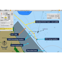
ATSB Releases Preliminary Report on Nuyina Grounding
echo sounders were switched off.“Depth information from the multi-beam system was shown on a dedicated display on the bridge but was not fed into the ship’s integrated bridge system. This meant the depth information was not displayed on the electronic chart display and information system (ECDIS), and could not be used to generate navigational alarms,” Mitchell said.Nuyina had been conducting the drone aerial survey work while holding position using its dynamic positioning system off Fur Seal beach before the voyage leader requested the master reposition the ship to a new location
Phase 1 of S-100 Implementation Complete
Nautical Products.The S-100 framework is a new global standard created by the International Hydrographic Organization (IHO), in collaboration with other hydrographic offices around the world, that enables the integration of diverse datasets within a single Electronic Chart Display and Information System (ECDIS) or other hydrographic application platforms.Users will be able to combine various data layers with electronic navigational charts including detailed depth information and dynamic information on tides and currents.S-100 builds on the digital foundation of S-57, the standard for ENCs since 1992, and
IHO Member States Adopt S-100 Operational Standards
International Hydrographic Organization (IHO) member states have adopted the first set of operational standards within the S-100 framework.The S-100 framework enables the integration of diverse datasets within a single Electronic Chart Display and Information System (ECDIS). Mariners will now be able to combine various data layers such as Electronic Navigational Charts (ENCs), detailed depth information and dynamic information on water level and currents to enhance situational awareness and decision-making.The adoption of the operational standards paves the way for coastal states to offer official
Sperry Marine Debuts Additional Military Layers on VisionMaster Radar and ECDIS
Sperry Marine has strengthened its portfolio of military navigation solutions with the release of Additional Military Layers (AML) for its VisionMaster series of Radars and ECDIS.The AMLs have been developed to allow defense and naval users to take advantage of Sperry’s commercial radar systems on demanding military assignments on small and large vessels. The latest enhancement supports the display of AMLs created to support both command and control and provide digital navigation systems that ensure the best situational awareness available for marine operations.By combining the navigational

Real-time ECDIS Updates via FleetBroadband
A contract signed in London at the end of last month by Inmarsat and SRH Marine SAIT formalizes arrangements for real-time Electronic Chart Display and Information System (ECDIS) updating to be accomplished ‘ship-to-shore’ using an application over FleetBroadband for the first time.The SRH Delta platform, which includes chart updates, publications and notices of mariners, will be available for L-band transmission to any FleetBroadband user equipped with the new, dedicated bandwidth Application Access Point Name (APN) developed by Inmarsat.“The SRH platform is the first application by