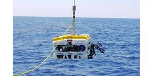
UKSR to Embark on 4th Mission to Survey Deep Sea Minerals
Minerals continues to build the integrated dataset required to advance toward commercial recovery and bring polymetallic nodules to market. The environmental data collected will contribute to ongoing efforts to understand and minimize the potential impacts of future nodule recovery. Findings from this expedition will be shared through peer-reviewed publications and public databases.In May 2026, Glomar Minerals announced Project Infinity, a consortium agreement with Cobalt Blue Holdings Limited to build a domestic critical minerals processing facility in the United States. Project Infinity, which has narrowed
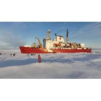
Multidisciplinary Scientific Expedition Sets Sail July 10 Aboard the CCGS Amundsen
An international, multidisciplinary scientific expedition will set sail on July 10 aboard the Canadian research icebreaker CCGS Amundsen. Until November 25, research teams will conduct operations across several strategic regions of the Canadian Arctic and Greenland, collecting samples and data to better understand the environmental and ecological changes affecting the North. The expedition will also help strengthen Canada's scientific presence in Arctic waters.Coordinated by Amundsen Science in partnership with the Canadian Coast Guard, this 139-day expedition will enable research teams to explore
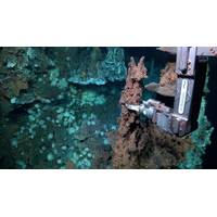
Subsea Hydrothermal Vents Discovered in the Doldrums Region
Scientists on a 35-day research expedition onboard Schmidt Ocean Institute’s R/V Falkor (too) discovered two new hydrothermal vent fields in a region of the middle of the Atlantic Ocean known as the Doldrums Megatransform and Fracture Zone, which lies just north of the equator about 800 miles off the northeast coast of Brazil. This large, tectonically active system cuts across the world’s longest mountain chain, the Mid-Atlantic Ridge. While many hydrothermal vents have been found along the ridge, these are the first known vent fields to be discovered in and around the Doldrums system.
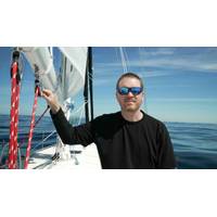
Explorer to Attempt Solo Unassisted Nonstop Circumnavigation of the Arctic Ocean
samples that we will use to test NASA ocean models monitoring Arctic waters. By taking action and communicating the story of his journey, he can help us reach our hard-earned $250,000 fundraising goal, directly advancing our science mission during the United Nations–designated Ocean Decade."Expedition at a GlanceOfficial start line: Aasiaat, Greenland, approximately June 25, 2026Three-Phase Route: Greenland → Russian Arctic coast (Northern Sea Route) → Northwest Passage → Baffin Bay → AasiaatPhase one: From Greenland, south around its tip, then north above Iceland
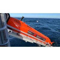
Norway Deploys New Deep-Sea Mapping AUV on First Expedition
Norway has launched the first expedition of a newly acquired autonomous underwater vehicle (AUV) designed to improve mapping and understanding of the country's deep-sea areas.The HUGIN Superior vehicle began operations in the northern Norwegian Sea earlier this month after being procured by the Norwegian Offshore Directorate (NOD) through funding provided by the Ministry of Energy in 2025.The deployment marks the first time Norway has access to its own advanced deep-sea mapping platform, a capability previously sourced through private contractors.“This is important for Norway. Now that we
Breaking the Ice on Arctic Research
is unique in its dual role, performing icebreaking and escort duties in the St. Lawrence Seaway in winter and Arctic science in the summer. Double duty means that all scientific equipment that is not part of the vessel must be loaded and installed on the Amundsen before the start of the annual Arctic expedition. Then, at the end of the expedition season, all equipment and collected samples are packed up and offloaded from the ship during an eight-day demobilization period.The scientific cargo and equipment for the five months of the 2026 Amundsen Expedition, explained Marine Research Coordinator Anissa
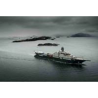
REV Ocean Launches Maiden Science Voyage to Support Marine Protection, Policy
in Rio de Janeiro in April 2027, alongside the UN Ocean Decade Conference, and runs through the South Atlantic, the Caribbean, the Sargasso Sea and the Eastern Tropical Pacific into late 2028. The missions will advance ocean science and support marine protection and policy work.The research and expedition vessel is designed to function as a convening platform. Boardroom, auditorium and meeting spaces are integrated into the ship's design, directly adjacent to its laboratories so that scientists, policymakers, sectoral and governance authorities and decision-makers can meet alongside the fieldwork
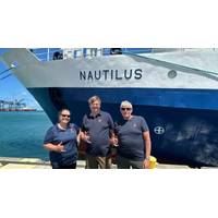
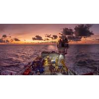
Kongsberg, Ocean Exploration Trust Launch Pacific Seabed Mapping Expedition
Kongsberg and the Ocean Exploration Trust (OET) have launched a seabed mapping expedition in the Central Pacific aimed at surveying previously unexplored areas of the ocean floor and testing next-generation mapping technology.The Pacific Mapping expedition, running from June 10 to June 24, will see OET's Exploration Vessel Nautilus deploy Kongsberg's EM 304 MKII multibeam echo sounder for the first time.Three Kongsberg engineers will be aboard the vessel throughout the 14-day mission, using the expedition as a platform to test and refine multibeam mapping technology under real-world operating
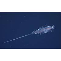
Schmidt Ocean Institute Research Team Discovers 31 New Species
An international team of midwater experts on board Schmidt Ocean Institute’s research vessel Falkor (too) discovered over two dozen new marine species on a recent expedition off the coast of Brazil in the tropical South Atlantic Ocean. The scientists used advanced technologies to explore the Ocean’s midwater — the water between the sunlit layer and the seafloor — which is Earth’s largest and least explored habitable ecosystem. It can take scientists decades to identify and describe new species, but the combination of technology and expertise enabled the team to confirm