
NOAA Selects Woolpert to Collect Topo-Bathy Lidar, Imagery for Remote Hawaiian Islands
georeferencing.The lidar and imagery collected under this NOAA NGS task order complements the topographic lidar Woolpert is currently collecting in Hawaii for the U.S. Geological Survey and for NOAA’s Office for Coastal Management. The Natural Resources Conservation Service, the Federal Emergency Management Agency and the State of Hawaii, Office of Planning, all contributed to the topographic lidar project.This acquisition is scheduled to start this spring, with data and imagery set to be delivered in late 2021 or early 2022
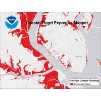
NOAA’s Flood Information Tool Expanded
Coastal Management. “Anything we can do to make people aware of their community’s vulnerability puts that community in a better position to act to save lives and property.” With this NOAA tool, users select their location and the flood scenario of their choosing: Federal Emergency Management Agency flood designations, shallow coastal flooding associated with high tides, or flooding associated with sea level rise or storm surge. Flood maps are then overlaid with any of three exposure maps to show how floodwaters might impact area assets. All maps can be saved, printed, and shared
IMB: Guard Against Threat of Cyber Attacks
should not be underestimated, and in June the US Government Accountability Office warned about the possible threats to US ports. In a stinging report, the organisation said that the actions taken by the Department of Homeland Security and two component agencies, the US Coast Guard and Federal Emergency Management Agency, as well as other federal agencies, to address cybersecurity in the maritime port environment have been limited. KPMG warns that hackers are the new open sea pirates. Wil Rockall a director in the organisation’s cyber security team highlights that the cyber security of maritime


