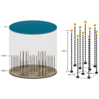
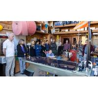
Sonardyne's Fetch Positioning Technology to Support Deepsea Neutrino Detector
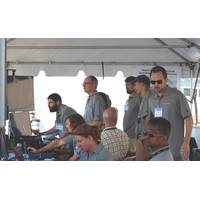
A new deep-sea neutrino detector being built to transform our understanding of the universe will use precise positioning from underwater technology company Sonardyne. An array of Sonardyne's Fetch instruments will provide the precise and stable underwater positioning the 3,000 m deep Pacific Ocean Neutrino Experiment (P-ONE) needs to accurately detect and analyze high-energy neutrinos. P-ONE, a multi-national, multi-institute scientific collaborative project, will help scientists to unlock insights into extreme cosmic phenomena like black holes and supernovae. The cosmic
Monitoring the Restless Earth for the Next “Big One”
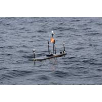
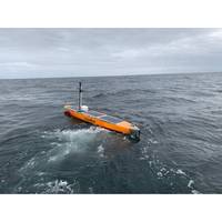
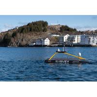
the US Pacific Coast, is being monitored.What is GNSS-A? GNSS-A works by combining satellite positioning with underwater acoustics to track seafloor movement with centimeter-level accuracy. An uncrewed surface vessel (USV) with Sonardyne’s GNSS-A payload patrols above an array of Sonardyne Fetch transponders on the seabed.Combining its known surface position with acoustic pulses down to each Fetch transponder allows it to calculate the precise position of each transponder – and therefore the position of the seabed it’s sitting on.By repeating these measurements over time, scientists
Shipwreck Windfall: ROV Expedition Captures Maritime History
for five years lived on the lake’s southern shore in Rochester, New York, had no idea about shipwrecks just below the waves.“When you get offshore in Lake Ontario, it can have conditions very similar to the ocean, right? It's not tidily affected, but there it’s big enough that the fetch allows the wind to generate storms and waves on the lake that are sufficient to sink a vessel like these,” explained Jason Fahy, associate director at OECI. “A majority of the wrecks that we were looking at happened in this November and early December timeframe when shipping companies
Sonardyne Holds Seabed Deformation Technical Workshop
equipment.GNSS-A and AZA are two independent technologies that are providing scientists with a ground-breaking new toolset for measuring seabed deformation caused by plate tectonic movements:• GNSS-A involves accurate (centimetric) global reference framework (principally horizontal) positioning of Fetch transponders on the seabed using an Uncrewed Surface Vehicle (USV).• AZA is a technique to accurately measure pressure (and thus vertical elevation) of a Fetch transponder. It does this by correcting for the inherent drift of the pressure sensor. This is also being increasingly used by scientists
New Record Set in Unmanned Vessel Data Collection
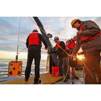
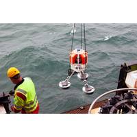
the first time successfully recovered scientific data from a sensor moored 1,800 meters deep in the Rockall Trough west of Scotland. The USV, deployed by the Oban-based Scottish Association for Marine Science (SAMS) and manufactured by AutoNaut in the UK, remotely collected data from the Sonardyne Fetch AZA bottom pressure recorders (BPRs), before sending it back to oceanographers on shore via satellite.Scientists say the successful mission is a step change in how oceanographic data is collected and reduces the reliance on ships for deep sea fieldwork.Professor Mark Inall, an oceanographer SAMS
Sonardyne Helps Study Ocean Currents for Climate Insights
the AMOC’s impact on our changing climate, scientists from the Scottish Association for Marine Science (SAMS) in Oban have deployed two deep-sea Bottom Pressure Recorders (BPRs), one in the north-east Atlantic and one in the Labrador Sea, to record regular changes in sea surface height.The two Fetch AZA BPRs, developed and built by Sonardyne, have been placed thousands of meters below the sea surface where they will record sea surface height to the nearest centimeter, giving the researchers a detailed comparison between the two locations. Deployed for up to 10 years, this will allow them to
Sonardyne Deploys 'New Breed' of Subsea Sensors at Shell's Ormen Lange Field
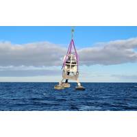
Marine technology company Sonardyne has deployed what it says is a new breed of underwater sensor that is able to self-calibrate, enabling precise, long-duration subsidence monitoring at all depths at Shell Ormen Lange offshore field. The company says this is the first such deployment at scale.The 20-plus Fetch Ambient-Zero-Ambient (AZA) pressure monitoring transponders (PMTs), developed by Sonardyne, will support an ongoing long-term, large-scale seabed monitoring project at Ormen Lange – Norway’s second-largest gas field – for A/S Norske Shell, the company said.Unlike traditional pressure
AUV Case Study: Marine Roboticists are Turning AUV Sight into Perception
of interest. Now, object detection and recognition can be done automatically.However, due to computational demands, many object detection solutions are designed to be run only after an AUV has returned to the surface and hand-delivered its data back to its operators. The AUV can effectively only play fetch. For an AUV to act on its survey data, such as by returning to an object of interest for closer inspection, its operators must perform costly and physically demanding re-deployments. “Launching and recovering an AUV is not a fun thing to do,” Balasuriya said. “It’s rocking
Seabed-to-Shore Data Delivery Operation Completed for Norske Shell
20) morning, without a single person having to travel offshore or from their home office, was achieved with significantly less emissions, health and safety risk and cost than could be done with a manned vessel.By using an XOCEAN XO-450 USV to harvest data from an array Sonardyne’s long-endurance Fetch pressure monitoring transponders, an estimated 5.4 tonnes of CO2 per day was prevented from being emitted into the atmosphere, had a manned vessel had been used. XOCEAN’s USVs have a negligible carbon footprint – around one thousandth of the emissions of a conventional vessel –