Teledyne Acquires ChartWorld International
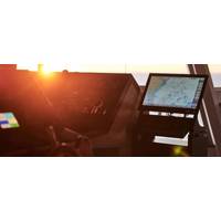
.Commercial maritime subscribers to ChartWorld’s software as a service (SaaS) receive free type-approved Electronic Chart Display and Information Systems (ECDIS), a lifetime warranty and global 24/7 support. ChartWorld also provides digital Electronic Navigational Charts (ENC) and other geospatial software and services, including digital route appraisal and voyage planning, as well as onshore software for fleet monitoring and risk assessment.ChartWorld affiliate SevenCs has a long history in the development of standards regarding electronic maritime chart display. Today, SevenCs continues to
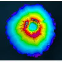
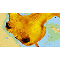
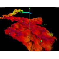
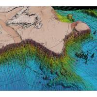
Teledyne Geospatial Partners with Seabed 2030 to Study Submarine Impacts of Volcanic Eruption in Tonga
mapping inside the caldera.For the duration of TESMaP, Seabed 2030 and Nippon Foundation-GEBCO Ocean Mapping Fellows utilized software provided by Teledyne CARIS (based in Fredericton, New Brunswick)—a Seabed 2030 partner with over 40 years of experience in developing hydrographic and marine geospatial software. The software was integral to the project as they facilitated the monitoring of data quality and coverage, with new data being used for comparative studies against previous maps to assess the effects of the eruption on marine life and seafloor composition. Software provided by Teledyne CARIS

Teledyne CARIS’ Padilla Earns National Award for Excellence
New Brunswick.“We’re all very excited to learn that Marta has received this award,” commented Patrick Bradley, Director of Engineering, Teledyne CARIS. “Having joined Teledyne CARIS last fall, Marta is already playing a key role in the development of the next generation of geospatial software products. She is an exceptionally talented developer with a rare combination of programming and geomatics skills and a feel for creating a great user experience. She is well on her way to making the world a better place for anyone who works with or relies on geospatial data.”
Teledyne to Acquire CARIS
Teledyne Technologies Incorporated and CARIS jointly announced that the CARIS business and its international affiliates have agreed to be acquired by a wholly-owned subsidiary of Teledyne. CARIS, headquartered in Fredericton, New Brunswick, is a developer of geospatial software designed for the hydrographic and marine community. Terms of the transaction were not disclosed. The closing of the transaction, which is subject to customary conditions, is anticipated to occur in the second quarter of 2016. Founded in 1979, CARIS pioneered software for processing and visualizing sonar data, as well

MTR100: CARIS
115 Waggoners Lane, Fredericton, New Brunswick, Canada E3B 2L4 T: 1-506-458-8533 / E: [email protected] / W: www.caris.com CEO/President: Dr. Salem Masry No. of Employees: 170 Established in 1979, CARIS is a developer of geospatial software designed to cater the marine GIS community and built on decades of hydrographic experience. CARIS is a privately held company with more than 170 engineering, IT and business professionals employed in its headquarters in Fredericton, Canada, as well as in CARIS offices in the Netherlands, the USA, Australia and the UK. In addition

Hamilton Named Product Manager for CARIS Onboard
Geospatial software developer CARIS announced that Travis Hamilton has joined its team as the product manager of the newest application in the CARIS software suite, CARIS Onboard. Hamilton has a bachelor’s degree in Geomatics from the University of New Brunswick and is currently completing his master’s degree. He has spent the last two years working in offshore survey as a data processor and operator of AUVs off the coast of Africa and other locations around the world. Hamilton is already familiar with the CARIS operation having recently worked under contract implementing a
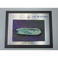
Canadian Government Unveils 3D Model of HMS Erebus
, Sir John Franklin’s lead ship found last year in Canada’s Arctic waters as part of Parks Canada’s search for the vessels of the lost 1845 expedition. The model was unveiled in Fredericton, New Brunswick. Officials from Fisheries and Oceans Canada joined with Canadian geospatial software company CARIS and geomatics technology innovation support centre TECTERRA to unveil the models. “Canadian innovation continues to play a major role in the ongoing successful efforts to explore, research and understand our maritime history," said MP Keith Ashfield. "
MTR 100: Caris
of its clients and the advancement of technology including support for Synthetic Aperture Sonar (SAS) data, as well as the exploration of Autonomous Underwater Vehicle (AUV) onboard data processing and near real-time product creation. For more than 35 years, CARIS has been a leading developer of geospatial software designed to cater to the marine GIS community and is built on decades of hydrographic experience. The CARIS Ping-to-Chart solution is designed to deliver an integrated and seamless solution for the complete workflow of hydrographic information from processing the echo-sounder ping to the production
Two New Products Launched from CARIS
Geospatial software solutions company CARIS announced the launch of two new products: the SIPS engine for side scan sonar processing and Limits and Boundaries Module. Both products will be on display and available for demonstration at Oceanology International 2014, March 11-13 in London. SIPS engine for side scan processing CARIS launched its new SIPS engine for side scan sonar processing in HIPS and SIPS 8.1. According to the manufacturer, the latest release of the hydrographic data processing system, which offers a single solution for bathymetry, seafloor imagery and water column data processing