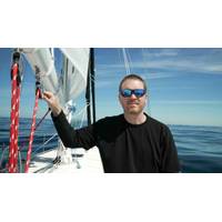
Explorer to Attempt Solo Unassisted Nonstop Circumnavigation of the Arctic Ocean
On June 25, solo sailor, explorer, researcher, and founder of the nonprofit Ocean Research Project, Matt Rutherford, will depart from Aasiaat, Greenland, where he will attempt the first-ever solo, nonstop, unassisted circumnavigation of the Arctic Ocean. His target finish is early October.The route covers more than 10,000 miles through three of the most hostile ocean environments on Earth: the North Atlantic, the Russian Arctic coast via the Northern Sea Route, and the Northwest Passage through the Canadian Arctic Archipelago. No one has completed this passage solo and nonstop. Until recently, no one
SAMS Oceanographic Array Will Aid Atlantic Meridional Overturning Circulation Observations
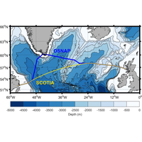
of moorings known as RAPID, which has been in place since 2004. Because AMOC transports heat northwards from the tropics, a weakening, or complete collapse, of this ocean system could potentially plunge western Europe into freezing temperatures more commonly associated with higher latitudes such as Greenland and Siberia.Project lead Dr. Neil Fraser of SAMS said SCOTIA had shown no clear signal that the AMOC was weakening at sub-polar latitude, but added this did not necessarily mean there was no overall weakening over a longer period of time. "The creation of the SCOTIA array and the methods we
Methane Hydrate Mining Could Soon Become Economically Viable
all of the coal, oil, and conventional natural gas in the world combined.Discoveries continue to be made. A team of international scientists from the Arctic University of Norway discovered the deepest known gas hydrate cold seep to date located 3,640 metres below the surface on the Molloy Ridge in the Greenland Sea in 2024.The storage and transport of natural gas in solid hydrate form, known as solidified natural gas (SNG), offers a promising alternative to conventional methods such as LNG and compressed natural gas, says a team of international researchers in a newly published studyon the economics of
The Politics of a Subsea Data Cable Link to Antarctica
to Five Eyes intelligence partner networks and the indirect association with military-linked infrastructure in other polar regions, even seemingly neutral cable infrastructure may be perceived as strategically exclusionary,” said the researchers.The attempted assertion of influence over Greenland by the Trump administration and the suspected acts of sabotage against the Svalbard cable underline the strategic significance of polar infrastructure.If approached inclusively, a subsea data cable to Antarctica could serve as a model for cooperative digital development. “Proposals for more
The Fate of Macroalgae and Why it Matters
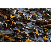
that globally, 4–44 teragrams (1Tg = one million metric tons) per year of macroalgal-derived carbon may reach depths of 200m, where it may be sequestered for at least 100 years.TheFebruary issue of Marine Technology Reporter magazine includes a feature on the fate of macroalgae in southwest Greenland. The study team, co-led by the Leibniz Institute for Baltic Sea Research Warnemünde and Helmholtz-Zentrum Hereon in Germany, used a combination of satellite imagery, ocean drifter tracking, numerical modelling and advanced turbulence analyses to demonstrate that extensive mats of macroalgae
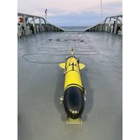
Teledyne Demonstrates Autonomous Systems for Anti-Submarine Warfare in the North Atlantic
were in attendance to witness the trials which were conducted from the Teledyne Gavia facility located in Kópavogur, Iceland. With assistance from the Icelandic Coast Guard, the Teledyne team was able to deploy the autonomous underwater gliders into the North Atlantic in the strategic Greenland – Iceland gap from the Coast Guard Ship ICGV Þór. The Sentinel Glider towed a passive acoustic thin-line hydrophone array specifically designed to identify surface and subsurface vehicle noise in the water. The silent autonomous gliders, transversing the water column to 1,000
New Study Reveals How Greenland’s Seaweed Stores Carbon in the Deep Ocean
An interdisciplinary study confirms, for the first time, the oceanographic pathways that transport floating macroalgae from the coastal waters of Southwest Greenland to deep-sea carbon reservoirs, potentially playing a previously underappreciated role in global carbon storage. Macroalgae, or seaweeds (including kelp), are highly productive coastal habitats capable of absorbing significant quantities of atmospheric carbon (CO₂). Previous studies have estimated that globally, 4–44 teragrams (1Tg = one million metric tons) per year of macroalgal-derived carbon may reach depths of 200m, where
New Map Reveals Terrain Below Antarctic Ice Sheet
bearing various topographical features."Possibly the type of landscape that many people might know less is 'plateaus dissected by deep-carved glacier valleys.' I can tell you this is very familiar for Scots, but also a landscape that is common across Scandinavia, northern Canada and Greenland. In fact, the very fact that the landscape our technique has uncovered across Antarctica matches these landscapes so well gives us great confidence in our new map," Bingham said.The researchers noted that until now the surface of Mars was better mapped than the subglacial terrain of Antarctica

Schmidt Ocean Institute Advances R/V Falkor (too)’s Mapping Capabilities
Schmidt Ocean Institute announced it has mapped two million square kilometers of seafloor — about the size of Greenland — and this year, has made two significant changes to advance the seafloor mapping capabilities of R/V Falkor (too): it changed the shape of the ship’s bow and added an Autonomous Underwater Vehicle (AUV) to its technology suite.Over a two-month dry dock period (April 28–June 28) in Talcahuano, Chile, the team reconstructed the bow of R/V Falkor (too), transforming it from a bulbous bow more common on offshore commercial vessels into a streamlined, V-shaped bow


