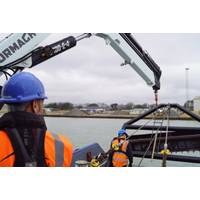
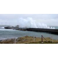
Seabed Leveling Completed at Newhaven
departure of the Port’s bucket dredger in the early 1990s.The plough has proven itself as an efficient dredging tool this week, with tug masters Darren Todman and Alex Davey completing bed leveling in Newhaven, which is sited at the mouth of the River Ouse in East Sussex.James Gray, assistant harbor master/marine works, said, ‘’Our tug crew at Shoreham Port were thrilled to provide essential seabed leveling services to Newhaven Port aboard our new tug boat Acamar on Tuesday. With two tug boats now working as part of our fleet, we have increased our availability to assist clients with
Sensor and AI System for Plymouth Sound
, Thales announced it was opening a new maritime autonomy center at Plymouth, with an aim to build relationships with industry and academia to operate unmanned vessels out of the Sound.M Subs is working with partners at the Plym Yacht Club, the Royal Plymouth Corinthian Yacht Club, the Queen’s Harbor Master, and of course Thales
Innovation Starts @ Marine Hub Cornwall
enough to have worked across a wide spectrum of areas within the marine technology industry. After 12 years being promoted through various Deck Officer roles, I became Chief Officer in the Merchant Navy in 1997. Having lived in the Cornwall my whole adult life, I returned to become Fowey's Deputy Harbor Master for a little under 11 years, investing my time in the local marine industry. At Fowey Harbour, in addition to port management duties, I developed the marine leisure business as a stand-alone business unit and played a key role in the harbor’s commercial shipyard management.From there I
Real-time Oceanographic Equipment Installed at Port Everglades
sensor (MWWL) that is a non-contact highly accurate sensor used to measure distance and can be used to monitor long-term sea level changes. The back-up water level sensor is a pressure-based sensor that measures water-level. The meteorological station has been located on the roof of the Port’s Harbormaster Tower and is outfitted with primary back-up wind sensors that provide wind speed and direction
Penobscot Bay Survey in Focus at NOAA Stakeholder Meetings
System, nowCOAST, and various planning tools such as SeaSketch and Northeast Data Portal. Allison Wittrock, from Marine Charts Division, presented the National Charting Plan with a focus on how it will provide great benefit to stakeholders. Various groups attended the event, including local harbor committees, regional U.S. Coast Guard, Maine Department of Marine Resources, NOAA Greater Atlantic Regional Fisheries Office, Maine Lobsterman’s Association, Maine Department of Environmental Protection, and staff from Rep. Bruce Poliquin (ME) and Sen. Angus King, Jr.’s (ME) offices.
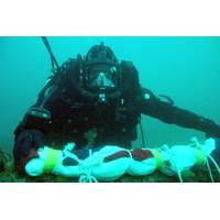
World War II Torpedo Found at Scapa Flow
end of the First World War in attempt to keep them out of allied hands. It is also the site of the wreck of HMS Royal Oak, the Revenge Class battleship which was torpedoed by a German U-Boat on October 14, 1939, with the loss of 883 lives. Brian Archibald, Orkney Island Council’s Harbor Master and Head of Marine Services, said, “Now that we know that the torpedo is German, we believe it is highly likely that it was among those fired at HMS Royal Oak by the U47 in October 1939.” “It’s location in Scapa Flow is in the vicinity of the area where, from
Surveyors Find Torpedo-like Object off Scotland
divers, from the Northern Diving Group at Faslane, are making a visit to Orkney this week and will use the opportunity to examine video footage of the object with the Orkney Harbor Authority before deciding what steps to take next. Although the object presents no immediate danger, the Orkney Harbor Master has asked shipping vessels not to anchor in the vicinity of the area where it was found. A precautionary 1,000-metre no-anchorage area has been put in place around the object, which is lying at a depth of 32 meters of water. The Orkney Harbor Authority will continue to update the U.K. Coastguard

OTT Hydrometry & the New Monitoring Network for Scottish Ports
in August 2014 and the network is now almost complete with sensors providing data every 1 minute via UHF radio to ‘gateways’ in the ferry offices, which then submit the data via the internet to a central server, which can be remotely accessed by authorized users,” said CMAL Harbor Master David McHardie. “We have a regulatory requirement to monitor the tide level in our statutory harbors, but this system also provides essential weather information for our ports. In the past, these measurements were taken manually, so the availability of continuous multiparameter data is
New Monitoring Network for Scottish Ports
the ferries, ports and harbors in the region, procured a network of 15 tide and weather stations from instrumentation specialist OTT Hydrometry. The new monitoring equipment provides live data on port conditions to enable the ferry sailing decisions to be made in a timely manner. CMAL Harbor Master David McHardie said, “OTT installed the first monitoring station in August 2014 and the network is now almost complete with sensors providing data every 1 minute via UHF radio to ‘gateways’ in the ferry offices, which then submit the data via the internet to a central


