MTR 100: Hypack
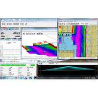
HYPACK reportedly was the first hydrographic surveying software in windows environment. It has become the standard package in the industry, and has all the tools needed to complete any job, with more than 8,000 users worldwide, and more than 25 years of experience. HYPACK, Inc. developed a Windows based software for the Hydrographic and Dredging Industry. Founded in 1984, HYPACK, Inc.(formerly Coastal Oceanographics, Inc.) has evolved from a small hydrographic consultant to a successful provider of hydrographic and navigation software worldwide. HYPACK provides the Surveyor with all the tools
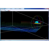
HYPACK to Release Real Time Point Cloud
Hydrographic surveying software company HYPACK, Inc. announced the release of its new REAL TIME POINT CLOUD, an upgrade to the HYPACK2014 release. The new program runs in conjunction with HYSWEEP SURVEY and displays both multibeam and topographic laser data in a corrected and geo-referenced color-coded point cloud. According to HYPACK , the REAL TIME POINT CLOUD program will be useful for easier feature detection and categorization, system calibration and verification, and data quality control. This program enhances the multibeam and topographic laser collection capabilities of HYSWEEP. HYPACK


