MTR 100: Hypack
HYPACK reportedly was the first hydrographic surveying software in windows environment. It has become the standard package in the industry, and has all the tools needed to complete any job, with more than 8,000 users worldwide, and more than 25 years of experience.
HYPACK, Inc. developed a Windows based software for the Hydrographic and Dredging Industry. Founded in 1984, HYPACK, Inc.(formerly Coastal Oceanographics, Inc.) has evolved from a small hydrographic consultant to a successful provider of hydrographic and navigation software worldwide. HYPACK provides the Surveyor with all the tools needed to design their survey, collect data, process it, reduce it, and generate final products. Whether the user is collecting hydrographic survey data or environmental data, or just positioning your vessel in an engineering project, HYPACK provides the tools needed to complete your job. With users spanning the range from small vessel with just a GPS and single beam echosounder to large survey ships with networked sensors and systems, HYPACK gives you the power needed to complete your task in a system your surveyors can master.
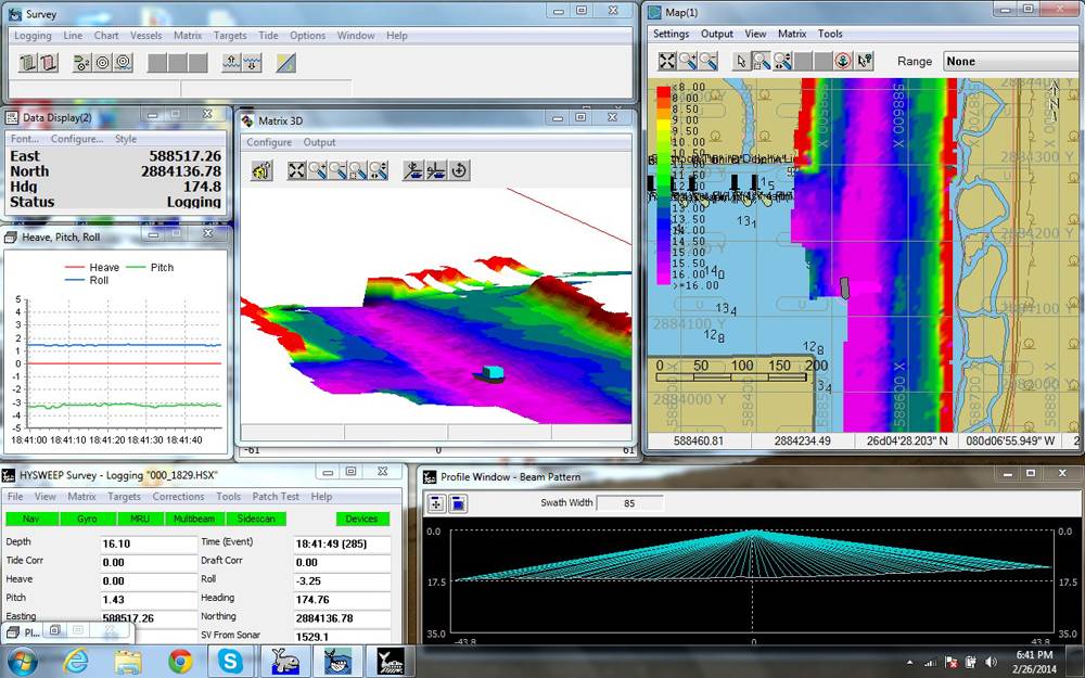
HYPACK, a hydrographic survey software with single beam, side scan, ADCP Mag, and subbottom support. HYPACK also has the CLOUD program that can be used for data review and final clean-up. There is also the TIN MODEL that creates stunning surface models, generates DXF contours and computes volume quantities with a variety of jobs. Large ship or small dinghy, HYPACK’s survey program gets your survey job done right. HYSWEEP is our powerful module for multibeam and topographic laser calibration, data collection and 64 bit processing. With its Patch Test that allows you to determine the exact mounting angles for your single head and dual head system in hours. HYSWEEP’s SURVEY provides you with coverage diagrams, relay time TPU displays, and QC tools needed to efficiently complete your multibeam survey. Lastly, HYSWEEP also has MBMAX, HYSWEEP and HYCUBE. DREDGEPACK is designed to show you how deep you are digging, how deep you need to be digging, and how deep you have already dug. Real time cross sectional profiles show you the ‘As Dredged’ and ‘As Surveyed’ surface displayed ‘along track’ or ‘across track’ for hopper dredges. For cutter suction dredges and excavators you can display a cross sectional profile along the arc of rotation. Included in DREDGEPACK is, Bucket patterns, Bucket reports, Dredge statistics, MTX Reporter, HYPLOT, CHANNEL DESIGN and ADVANCED, and CHANNEL DESIGN.
(As published in the July/Aug 2014 edition of Marine Technology Reporter - http://www.marinetechnologynews.com/Magazine)