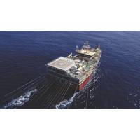
TGS to Advance Offshore Seismic Development In Equatorial Guinea
and geophysical data across the country’s offshore basins.The agreement covers the reprocessing of legacy seismic datasets as well as the acquisition of new data, aimed at improving subsurface understanding and supporting exploration activity in the region.Under the deal, TGS will apply its imaging technologies to reimage existing datasets of varying vintages and deliver an integrated approach combining seismic acquisition, processing and interpretation.“Through this agreement, TGS can provide access to a comprehensive data framework, including local, regional, and basin-wide datasets through
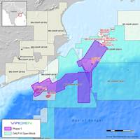
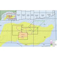
Viridien Starts Seismic Reprocessing Initiative for India’s Offshore Basins
.The aim of the Phase 1 Mahanadi Basin reimaging project is to provide higher-quality imaging over proven petroleum system areas, as well as deeper water areas where exploration of new thermogenic plays has been challenging due to low-quality imaging of legacy data.Viridien will apply the latest imaging technologies, such as time-lag full-waveform inversion (TLFWI) and least-squares PSDM (LSQPDSM), to address these challenges and produce seamless, high-quality merged 3D datasets.“The innovative imaging technology and regional expertise provided by Viridien, combined with phased project expansion
Viridien Launches Charrua 3D Seismic Survey Offshore Uruguay
Viridien has kicked off the Charrua 3D multi-client seismic survey offshore Uruguay, marking a new phase of exploration activity in the country’s offshore basins.Data acquisition will be carried out by the vessel BGP Prospector, with the company applying seismic imaging technologies including time-lag full-waveform inversion (TLFWI) to produce high-resolution subsurface images.The survey expands Viridien’s multi-client seismic data coverage and reflects growing industry interest in the southern Atlantic Margin, where offshore basins in Uruguay share geological similarities with Namibia&rsquo
Viridien Teams Up with NVIDIA to Accelerate Seismic Imaging Workflows
Viridien has entered into a collaboration with NVIDIA to advance high-performance computing (HPC) capabilities for seismic imaging workflows, focusing on optimizing subsurface imaging technologies on NVIDIA accelerated computing platforms.The initiative will center on enhancing Viridien’s seismic imaging algorithms using NVIDIA HPC platforms, incorporating advanced features such as tensor cores and mixed-precision computing. The companies aim to improve system performance, imaging accuracy and operational efficiency for energy and geoscience clients worldwide.The collaboration combines Viridien&rs
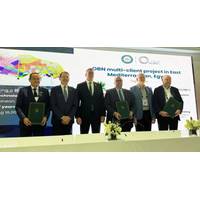
Viridien, SLB Set to Launch ‘Massive’ OBN Survey Offshore Egypt
;This agreement with SLB and EGAS marks a significant milestone for Viridien, giving new momentum to our commitment to Egypt as a key partner with over 30 years of in-country operating experience. Expanding our multi-client data library into the Egyptian Eastern Mediterranean with our advanced OBN imaging technologies will help showcase Egypt’s subsurface opportunities to the world,” added Dechun Lin, Head of Earth Data, Viridien
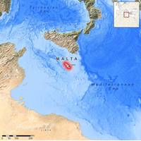
Viridien Gets On Board Integrated Multi-Client Data Project off Malta
multi-client dataset for the country’s offshore area.By revitalizing existing seismic and well data, this project will advance the understanding and promotion of Malta’s offshore petroleum potential in the Central Mediterranean.Through this agreement, Viridien will deploy its high-end imaging technologies and advanced workflows to significantly enhance data quality and subsurface insight.A regional geological study, based on this newly integrated dataset, will also provide a much clearer view of the petroleum systems and prospectivity of Malta’s offshore acreage, supporting future licensing
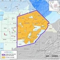
Viridien Kicks Off Multi-Client Reimaging Program off Malaysia
French seismic firm Viridien has announced a new basin-scale reimaging program within the hydrocarbon-prolific Balingian-Luconia-Baram basins, in collaboration with Petronas, through Malaysia Petroleum Management.Viridien will leverage its imaging technologies to reimage 44,000 km2 of legacy 3D seismic data, starting in January 2026 with a basin-wide post-stack merge to deliver early data and key insights for further high-end reimaging.Prefunding is now open, allowing early participants to access initial results and benefit from enhanced imaging beneath complex carbonate sequences and resolve long-stand
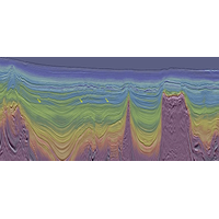
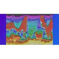
Viridien Completes Reimaging of BM-S-2 Multi-Client Survey in Santos Basin
seismic reimaging project in the southern Santos Basin, delivering a modern, high-fidelity 3D dataset across 8,468 sq km to support growing exploration activity in one of the most strategic, emerging offshore regions of Brazil.The project upgrades a large legacy survey with the latest advanced imaging technologies, including time-lag full waveform inversion (TL-FWI), to provide clearer definition of post-salt stratigraphy, improved visibility of potential direct hydrocarbon indicators (DHIs), and new insights into underexplored pre-salt plays. The reimaged BM-S-2 survey seamlessly integrates with Viridien&rs
Viridien, TGS Wrap Up OBN Survey in Gulf of America
exploration in Keathley Canyon,” said Dechun Lin, EVP, Earth Data, Viridien.“Laconia Phase III is designed to significantly enhance imaging, optimizing near-term exploration of the critical Paleogene play. Through cooperation with Viridien, utilizing leading-edge OBN acquisition and imaging technologies, we expect sharper subsalt definition, more reliable velocity models and clearer fault imaging supporting both regional and infrastructure-led exploration,” added David Hajovsky, EVP Multi-Client at TGS