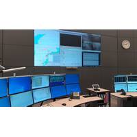
Wintershall Noordzee Deploys Wärtsilä Software to Boost Offshore Safety
early warning system to avoid allisions between the offshore platforms and vessels in their vicinity. It works by providing remote access to Automatic Identification System (AIS) or Vessel traffic Service (VTS) data sources to maintain constant and full situational awareness, using a standard internet browser. "The WebVTS decision support tools effectively mitigate potential marine hazards and risks. The application also supports navigational maps, traffic management tools, ship history, and works in various languages," Wärtsilä says.Manué Gerrits, Central Control
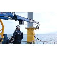
ROVCO Completes Galloper Offshore Wind Farm Project
month.For the project ROVCO inspected all 56 turbines at the Galloper Wind Farm. Data for this project is being delivered via Rovco’s in-house Data Command Center, a proprietary software system which allows for all the various datasets collected to be combined and presented through a simple internet browser. Within the platform, Rovco’s clients view survey data libraries, reports, videos and 3D point clouds, as well as use tools to measure point-to-point distances, surface areas and volumes, providing a streamlined workflow for future asset management

Senergy S&G Wins Construction Survey Support Contract
S&G will also deploy its innovative web-based GIS (Geographic Information Systems) and project information system, IRIS. The application enables project teams to track real-time vessel locations and access key project status information and as-built survey and video data – all through an internet browser. In addition, Senergy S&G will provide the developer with oversight of the trenching and backfill systems and operations for the pipeline assets. Senergy became a member of the Lloyd’s Register (LR) Group in September 2013, following an agreement for LR to take a significant investment
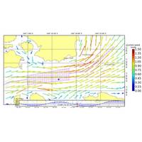
Singapore and Malacca Straits Tidal Models Released
commercial tidal models for the Singapore and Malacca Straits have been released in an exclusive online viewer. Developed by applied oceanography specialist Tidetech, the online viewer – OceanView – is an entry-level version of the company’s tidal models, viewable on any internet browser and on internet capable mobile devices. OceanView offers a detailed tidal current atlas featuring tidal current predictions at 1km resolution for every 30 minutes. Other features include latitude and longitude, place names, scale showing speed of current in knots (no interpolation necessary)