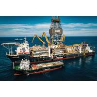
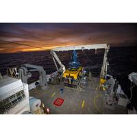
Trump Order Fast Tracks Subsea Mining
to extract nodules from a vast plain of the Pacific Ocean between Hawaii and Mexico known as the Clarion-Clipperton Zone.Beyond The Metals Company, others eyeing deep-sea mining include California-based Impossible Metals, Russia's JSC Yuzhmorgeologiya, Blue Minerals Jamaica, China Minmetals, and Kiribati's Marawa Research and Exploration.U.S. access to critical minerals - especially those produced by Chinese companies - has dwindled in recent months as Beijing has limited exports of several types. That, in turn, has ratcheted up pressure on Washington to support efforts to boost domestic mining
White House Could Bypass UN on Deep-Sea Mining
aimed to partner with Kingston on energy-related projects, including "mining opportunities off the seabed."Beyond The Metals Co, other companies eyeing deep-sea mining include California-based Impossible Metals, Russia's JSC Yuzhmorgeologiya, Blue Minerals Jamaica, China Minmetals, and Kiribati's Marawa Research and Exploration.(Reuters - Reporting by Ernest Scheyder and Jarrett Renshaw; editing by Richard Valdmanis and Marguerita Choy

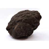
MTR100: Deep-sea Mining May Prove Pivotal in the Climate Change Discussion
begin mining; too little is known about the seabed and its ecosystems, and the long-term impacts of mining are impossible to determine at this point. On September 8, French Polynesia became the most recent territory to call for a ban on DSM, calling out their “cousins of the Pacific”—Kiribati, Nauru and the Cook Islands—for pushing forward with mining despite only having explored about 5% of the seabed. “If we have to examine what’s on the ocean floor, it should be solely for the acquisition of knowledge, not for exploitation purposes,” said Minister for Marine
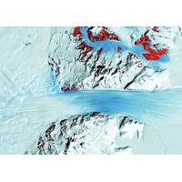
'Doomsday’ Glacier Could Trigger Global Floods and Swallow Islands
ice cliffs that collapse into the ocean.A sea level rise of several meters would inundate many of the world’s major cities – including Shanghai, New York, Miami, Tokyo and Mumbai. It would also cover huge swathes of land in coastal regions and largely swallow up low-lying island nations like Kiribati, Tuvalu and the Maldives.As big as BritainThwaites is a frozen river of ice approximately the size of Great Britain. It already contributes around 4% of the global sea-level rise. Since 2000, the glacier has had a net loss of more than 1000 billion tons of ice and this has increased steadily over
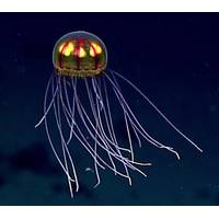
Deep Sea Science:Deep Sea Reveals Insights on Human Immunity
Immunology.The findings, published last week, contradict the long-held belief that human cells can recognize any bacteria they come across. The study, conducted by researchers at the Rotjan Marine Ecology Lab at Boston University, the Kagan Lab at Boston Children's Hospital and the government of Kiribati, looked at the properties of bacteria from the deep sea collected on a Schmidt Ocean Institute expedition in the Southern Pacific Ocean.Bacteria from the deep sea were found to have "immuno-silent properties" that neither harm nor benefit the body and in fact are not even detected by the
SOI Maps One Million Square Kilometers of Seafloor
regions that require high-resolution seafloor imagery to contribute to expansion or additional protections. Some of its large mapping efforts have focused on the Papahanaumokuakea Marine National Monument in Hawaii, Cocos Island National Park in Costa Rica, and the Phoenix Islands Protected Area in Kiribati.Gaining visuals of the ocean floor is critical to unlocking a better understanding of the world’s oceans. There are predicted to be millions of unknown species whose function and contribution to ocean and human health is still unknown. High resolution maps guide scientists to these unexplored
UKHO Contracts with TCarta
TCarta Marine was contracted by the United Kingdom Hydrographic Office (UKHO) to provide a baseline dataset of water depths and seafloor classification around the Republic of Kiribati. Located in the Pacific Ocean, the island nation is threatened by rising sea levels.TCarta won the open bid for supply of Satellite Derived Bathymetry (SDB) to the UKHO to extract water depth measurements and seafloor classifications, including habitat types, from multispectral satellite imagery. In this project, TCarta is processing eight-band DigitalGlobe WorldView-2 and -3 data predominantly, as well as four-band
Seas to Continue Rising Even if Climate Goals Are Met
Greenland to Antarctica that will re-draw global coastlines, a German-led team wrote in the journal Nature Communications. Sea level rise is a threat to cities from Shanghai to London, to low-lying swathes of Florida or Bangladesh, and to entire nations such as the Maldives in the Indian Ocean or Kiribati in the Pacific. By 2300, the report projected that sea levels would gain by 0.7-1.2 metres, even if almost 200 nations fully meet goals under the 2015 Paris Agreement, which include cutting greenhouse gas emissions to net zero in the second half of this century. Ocean levels will rise inexorably
NOAA's Okeanos Explorer Journeys Into Pacific Deepwater
areas of Howland, Baker and Jarvis Islands, Palmyra Atoll and Kingman Reef, and Johnston Atoll. While this year’s dives will focus on waters of the United States Exclusive Economic Zone, NOAA will partner with several Pacific Island countries to explore the deep waters of Samoa, the Republic of Kiribati’s Phoenix Islands Protected Area, the Cook Islands, and New Zealand’s Territory of Tokelau. CAPSTONE, which began in July 2015, focuses on collecting baseline information to support science and management needs in these vast and largely unexplored areas. CAPSTONE also provides