Breaking the Ice on Arctic Research
. Credit: Amundsen ScienceSetting SailCCGS Amundsen's 2026 season starts on July 10 and, at 139 days, marks the longest expedition since 2009. The vessel will carry more than 185 scientists from Canada and beyond over the course of five legs, studying the marine and coastal environments of the Labrador Sea, the Canadian Arctic and Greenlandic waters. Amundsen will travel first from Quebec City to Iqaluit, then to Pituffik Space Base, then on to Resolute Bay, before returning to Iqaluit and finally Quebec City."This season, we are welcoming many new research teams aboard the Amundsen. They are
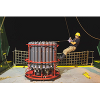
Ocean-Bottom Seismometers Play Crucial Role in Offshore Sensing
from the Explorer Plate and redeployed offshore Haida Gwai.In back-to-back cruises, this will be followed immediately by recovery of 18 units from the Endeavour Ridge in early August, with redeployment of five instruments.In September/October, 22 instruments are scheduled for recovery from the Labrador Sea.Two major international expeditions are under discussion for 2027 or 2028—a large-scale active-source survey on the East Pacific Rise and a significant research campaign off the coast of Chile.Efforts are also underway to improve the speed of data processing and interpretation, closing the
New Study Reveals How Greenland’s Seaweed Stores Carbon in the Deep Ocean
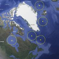
occurs.Those findings were supported by analysis of more than 1,300 Sentinel-2 satellite high-resolution, multi-spectral images, via a service run by the EU’s Copernicus program. These images revealed nearly 8,000 floating macroalgae patches across the Greenland shelf sea and the adjacent Labrador Sea, confirming widespread offshore presence of macroalgae.[A] Locations of floating mats of macroalgae color-coded by month. Also shown are the combined footprints of the Sentinel-2 tiles and the 1000m isobath (dashed black line). Floating algae index [B] and true color [C] Sentinel-2 image from
An Unintentional Iron Fertilization Experiment
robots that can measure some nutrients (for example, the Biogeochemical Argo floats). Development of sensors to measure iron would represent a major leap forward.”In other phytoplankton and climate change news, a fleet of ocean robots has been deployed to explore the depths of the Labrador Sea as part of a year-long experiment led by scientists from the UK’s National Oceanography Centre. They are studying the ocean processes that help remove carbon dioxide from the atmosphere and store it in the deep sea
Mother Ship with USV Flotilla Could Boost Coast Guard Capabilities
to the Arctic (32 years ago). The Louis S. St-Laurent's replacement was first planned in the 1980s, but the replacement vessel has yet to enter service.An expediated alternative to such challenges could be a mother ship suitable and seaworthy for the purpose intended. For instance, for the Labrador Sea, the mother ship could be based on a 45-50m offshore tug or standby emergency response vessel. The ship layout could include rescue facilities, towing capability, winches, a flotilla communications hub, and fuel and stores capacity for 60 days of operation.The intent is for the mother ship to
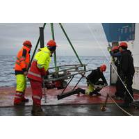
Ocean Robots Explore the Role of ‘Marine Snow’ in Carbon Storage
A fleet of ocean robots and instruments has been deployed to explore the depths of the Labrador Sea as part of a year-long experiment led by scientists from the UK’s National Oceanography Centre (NOC).The ReBELS project (Resolving Biological Carbon Export in the Labrador Sea) is investigating the biological carbon pump, a key ocean process that helps remove carbon dioxide from the atmosphere and store it in the deep sea and without which atmospheric CO₂ would be 50% higher.“The biological carbon pump plays a crucial role in regulating Earth’s climate,” said project
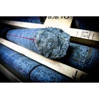
Drilling Greenland Bedrock Shows Rise to Life in the Deep Biosphere
into lead. The dating gave ages of 64-75 million years”, says Henrik Drake, Associate Professor at Linnaeus University, Sweden, and lead author of the study.These ages overlap with tectonic events related to the early stages, or precursors, of the opening of the Atlantic Ocean and the Labrador Sea. This suggests that deep fracture networks in western Greenland opened and were colonized by microorganisms, such as sulfate reducers, during these events. The movements of the continents have thus influenced how the deep biosphere has been colonized.Henrik Drake explain the findings as chemical
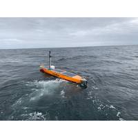
New Record Set in Unmanned Vessel Data Collection
for oceanography as it opens up a new way of collecting more data, more regularly, which is key to improving climate predictions and helping us to prepare for what the future may hold.”Last year SAMS deployed two BPRs on the seabed of the Atlantic Ocean: in the Rockall Trough and in the Labrador Sea, east of Canada. Based on the weight of the water above it, the instrument can detect a change in pressure that is the equivalent to a sea-surface height change of one centimeter.By comparing the sea surface height on the western and eastern flanks of the Atlantic Ocean, oceanographers can calculate
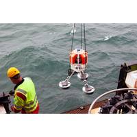
Sonardyne Helps Study Ocean Currents for Climate Insights
, the ocean’s absorption of carbon and European weather.To measure the AMOC’s impact on our changing climate, scientists from the Scottish Association for Marine Science (SAMS) in Oban have deployed two deep-sea Bottom Pressure Recorders (BPRs), one in the north-east Atlantic and one in the Labrador Sea, to record regular changes in sea surface height.The two Fetch AZA BPRs, developed and built by Sonardyne, have been placed thousands of meters below the sea surface where they will record sea surface height to the nearest centimeter, giving the researchers a detailed comparison between the two