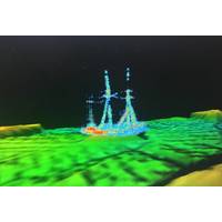
Discovery: Historic Shipwreck Found in Lake Huron
Researchers from NOAA, the state of Michigan, and Ocean Exploration Trust discovered an intact shipwreck resting hundreds of feet below the surface of Lake Huron. Located within NOAA's Thunder Bay National Marine Sanctuary, the shipwreck has been identified as the sailing ship Ironton. Well preserved by the cold freshwater of the Great Lakes for over a century, the 191-ft. Ironton rests upright with its three masts still standing."Using this cutting-edge technology, we have not only located a pristine shipwreck lost for over a century, we are also learning more about one of our nation's
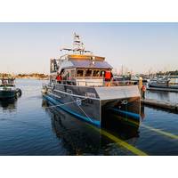
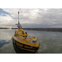
AAM Launches 50’ Research Vessel for NOAA
vessels for NOAA, and we are always excited to work with this essential agency. The Office of Marine Sanctuaries serves as the trustee for a network of marine protected areas encompassing more than 600,000 square miles of marine and Great Lakes waters from Washington state to the Florida Keys, and from Lake Huron to American Samoa.”(Photo: All American Marine)On board the vessel there is approximately 250 square feet of working space on the aft deck, with a complete complement of working gear and an extensive grid of deck sockets. The deck sockets are spaced every two feet and allow equipment and
Fugro to Deploy Latest RAMMS Tech to Map Lake Huron
Fugro is mobilizing its Rapid Airborne Multibeam Mapping System (RAMMS) to Ontario, Canada, to acquire 3,147 square kilometers of high-resolution bathymetry data over Lake Huron for the Canadian Hydrographic Service (CHS).The survey is expected to last six months from data collection to data delivery and will support the agency’s ongoing nautical charting updates in the country’s Great Lakes region.Fugro has used RAMMS throughout North America, the Caribbean and Europe since launching the next-generation airborne lidar system in 2018. In addition to nautical charting, RAMMS has supported
Saginaw Bay’s Marine Ecosystem Revival
ocean. And when we go back to the sea, whether it is to sail or to watch – we are going back from whence we came” – John F. KennedySaginaw Bay’s warm waters serve as nursery grounds for many fish species and support the fisheries of both Saginaw Bay and the main basin of Lake Huron. Historically, inner Saginaw Bay contained rock reefs that provided critical habitats, spawning grounds, and juvenile areas for many native fish species. This includes Walleye, Smallmouth Bass, and Suckers during the spring and Lake Whitefish, Cisco, Lake Trout, and Burbot in the fall.As human
Searching for Shipwrecks
The ice had barely retreated from the coast of northern Lake Huron this spring when a group of farflung researchers converged in Rogers City, Michigan. They were there to map unexplored areas of Thunder Bay National Marine Sanctuary. If all went well, they would discover new shipwrecks and natural features such as sinkholes, fish habitats, and interesting geological formations.During the two-week expedition, researchers mapped areas within the sanctuary with a multibeam sonar system aboard autonomous surface vehicle ASV BEN (Bathymetric Explorer and Navigator) from University of New Hampshire’s
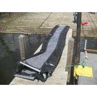
Coast Guard Tests Underwater Oil Barrier System
conditions and the type of oil spilled, oil can sink to the bottom of inland water bodies and travel with the current.RDC returned to Michigan in late May to test an underwater barrier system designed for offshore environments and large lakes. The test was conducted from Coast Guard Cutter Hollyhock in Lake Huron near Port Huron.RDC will consolidate results and lessons learned from both tests into a single report and make it available to the public
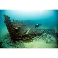
Two Shipwrecks Found in Lake Huron
identified two previously undiscovered historic shipwrecks in Thunder Bay National Marine Sanctuary. The shipwrecks are the wooden steamer Ohio (1873-1894) and the steel-hulled steamer Choctaw (1892-1915). In May 2017, a sanctuary-led expedition used high-resolution sonars to map the bottom of Lake Huron, during which they located the two ships. At the time, researchers were confident they had discovered the 202-foot Ohio and the 266-foot Choctaw. The team recently confirmed the vessels’ identities using underwater robots to collect photos and video of the shipwrecks. The

Cutting Edge Tech Helps Find Lake Huron Shipwrecks
Researchers at NOAA’s Thunder Bay National Marine Sanctuary have recently completed a four-phase research project to test the application of technology to locate, document and explore shipwrecks lost in Lake Huron. Under a grant from NOAA’s Office of Ocean Exploration and Research, Thunder Bay National Marine Sanctuary assembled an interdisciplinary team of researchers from around the country to support an expedition based from the sanctuary’s Great Lakes Maritime Heritage Center in Alpena, Mich. Thunder Bay’s superintendent, Jeff Gray, summarized the importance
History Meets Technology in Shipwreck Alley
The vast stretches of cold, fresh water in the Great Lakes hide the stories of thousands of ships that wrecked in our nation’s inland seas. Historical records indicate more than a hundred shipwrecks have yet to be discovered in Lake Huron’s Thunder Bay National Marine Sanctuary, and research teams hope to discover more this summer. From April through August, Thunder Bay National Marine Sanctuary will lead four different teams using advanced technologies to push the boundaries of underwater archaeological survey and seek yet-to-be-discovered shipwrecks within the sanctuary.


