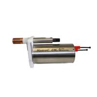
Ocean Business '25: 4H-JENA Engineering Sensors
. With a strong emphasis on environmental monitoring, the company will highlight how its technology supports marine research, climate change studies, and commercial oceanographic applications.Among the innovations in focus will be the CONTROS CombiSensor CO2 / CH4, which integrates carbon dioxide and methane gas measurements into a single compact unit. Designed for deployment on autonomous platforms with limited payload capacity, the sensor is also ideal for installations on commercial vessels and fixed monitoring stations, enabling long-term, reliable data collection for climate research and environmental
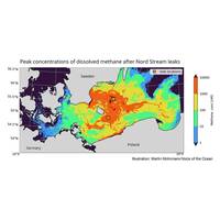
Nord Stream Methane Spread Below Surface for Several Months
Methane from the Nord Stream pipelines destroyed in September 2022 spread over a large part of the southern Baltic Sea and remained for several months, according to a new study by researchers from the University of Gothenburg and the Voice of the Ocean research foundation.Much of the methane gas from the Nord Stream leak rose directly to the sea surface and into the atmosphere. But some methane remained below the surface and was dispersed by ocean currents.“The results of our measurements show that methane spread to large parts of the southern Baltic Sea, from the coast of Danish Zealand in the
Frozen Methane Under the Seabed is Thawing – And It's Worse Than We Thought
Earth so, despite being hundreds of metres below the seafloor, it is right at the point of instability.Some layers of sediment are permeable and create a complex underground plumbing for the gas to move through if it’s liberated during climatic warming. Just like holding a football underwater methane gas wants to push upwards because of its buoyancy and burst through the 100s of metres of sediment layers.Imposed upon this complex geology has been the seven glacials (or ice ages) and interglacials, which warmed and cooled the system repeatedly over the last million years.Example of the sort of
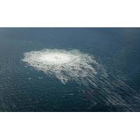
Nord Stream Breaches a Stark Reminder of Undersea Infrastructure Vulnerabilities
following gradual supply reductions during the summer.Nord Stream 2 was never launched as Germany refused to certify it following Russia’s invasion of Ukraine. Europe was not counting on the resumption of supplies from either pipeline.While the pipelines were not transmitting gas, they contained methane gas to maintain pressure.The amount of gas released is hard to quantify. Estimates suggest that roughly 300,000 tonnes of methane (or the equivalent of 7.5 million tonnes of carbon) has probably been released into the atmosphere, making it the largest release of methane in a single event (and over
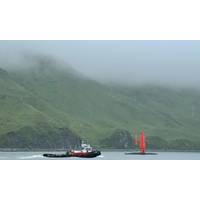
Uncrewed Saildrone to Explore Remote Alaskan Waters
Okeanos Explorer. Scheduled for 2023, these expeditions will continue to fill additional seafloor mapping gaps and use remotely operated vehicles to further explore and sample features and resources of interest identified during the Aleutians Uncrewed Ocean Exploration expedition (e.g., seamounts, methane gas seeps, hydrothermal vents).The Aleutians Uncrewed Ocean Exploration expedition is the first project to result from a January 2022 interagency agreement between NOAA and BOEM that facilitates more efficient resource sharing and supports at-sea fieldwork in areas of common mission interest.NOAA
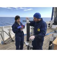
Linnaeus University: Seabed Pollution Helps Measure Effects of Climate Change
Stockholm University and the Geological Survey of Sweden. The route begins in Norrbotten, in the far north of Sweden, and ends in Skåne, in the south, with the group making 14 sampling stops along the way. During the voyage, researchers study water temperature, salinity, oxygen levels, sediment, methane gas, organic material, and other chemical parameters.Aside from identifying the quantity of hazardous metals, the researchers hope to analyze the amount of methane gas, and how much of that is emitted from the seabed into the water and air, thereby increasing the level of greenhouse gases in the atmosphere
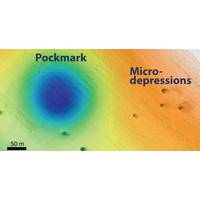
Researchers Find Mysterious Seafloor Holes
sides than the pockmarks and are often elongated in one direction.Map showing the locations of some of the pockmarks and proposed wind-farm areas off Central California. Image: © 2019 MBARISeafloor pockmarks have been found elsewhere around the world, and have been associated with releases of methane gas or other fluids from the seafloor. Such methane releases could potentially cause the seafloor to be unstable, which could pose risks for structures such as offshore oil platforms or wind turbines. However MBARI researchers found no evidence of methane in the sediment or seawater in this
New Tech Simulates Methane Hydrate Recovery
deposits and cobalt rich crust.In particular, shallow methane hydrate — an ice-like solid material composed of water and methane molecules — can only exist in stable form under the low-temperature, high-pressure conditions of the seabed. Methane hydrate partially dissociates into methane gas and water as it is being raised from the seabed to the ocean surface, leading to major changes in the proportions of solid (methane hydrate), gas (methane) and liquid (seawater) in vertical lifting pipes used to raise the material to the surface.Developers seeking to design equipment for subsea
Methane: The Arctic's Buried Treasure
carbon recycling system related to gas hydrates from the sub-seabed to the atmosphere. First, we accomplish 4D time-lapse seismic studies to visualize potential sub-seabed gas hydrate accumulation and gas migration pathway areas. Second, we work in the water column taking both ocean spatial and methane gas concentration measurements using different types of laser spectrometers but also test new technologies in collaboration with the Laboratoire de Glaciologie et Géophysique de l’Environnement (LGGE) in Grenoble, France. Oxygen isotope measurements identify where the methane sources


