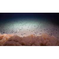
Deep-sea Mining Threatens “Twilight Zone” Ecosystem
zooplankton and 60% of micronekton, which feed on zooplankton, would be impacted by the discharge of the mining waste, which could ultimately impact predators higher up on the food web.“When the waste released by mining activity enters the ocean, it creates water as murky as the mud-filled Mississippi River. The pervasive particles dilute the nutritious, natural food particles usually consumed by tiny, drifting zooplankton,” said Michael Dowd, lead author of the study and oceanography graduate student in the UH Mānoa School of Ocean and Earth Science and Technology (SOEST).“Micronekton

NOAA, Partners to Announce Findings From 2025 Gulf of America "Dead Zone" Monitoring
record-setting 8,776 square-mile dead zone observed in 2017.During the teleconference, speakers will discuss factors influencing this year’s zone size, potential impacts to living marine resources, the accuracy of the spring hypoxia forecast, and ongoing federal and state initiatives in the Mississippi River watershed focused on reducing nutrient runoff into the Gulf.Speakers will include:Cassandra Glaspie, Associate Professor, Louisiana State University; Chief scientist of survey cruiseSean Corson, Director, NOAA’s National Centers for Coastal Ocean ScienceGretchen Oelsner, Hydrologist,

Gulf of Mexico Dead Zone More Than Double 2035 Target
the size of New Jersey.Scientists at Louisiana State University and the Louisiana Universities Marine Consortium (LUMCON) led the annual dead zone survey July 21–26 aboard LUMCON research vessel Pelican. This annual measurement is a key metric that informs the collective efforts of the Mississippi River/Gulf of Mexico Hypoxia Task Force, a state/federal partnership which has set a long-term goal of reducing the five-year average extent of the dead zone to fewer than 1,900 square miles by 2035.TOP: Map of measured Gulf hypoxia zone, July 21–26, 2024. Red area denotes 2 mg/L of oxygen
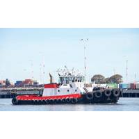
US Harbor Craft: Measuring Opportunity for Zero Emissions
tugboats are considered the closest segment technically for the adoption of the HyZET technology, compared to, say, the towboat segment, which in California includes a number of oceangoing ATBs that may prove less ready for the HyZET concept compared to, for example, towboats operating on the Mississippi River.“The ferry and excursion vessels and pilot boats, especially those operating on the routine ferry routes, are generally well suited for zero-emission technologies, such as hydrogen and electricity,” Lewis added. “That said, some of the excursion vessels that venture further
Shell Aims to Harness the Power of the Lower Mississippi
ORPC, an marine renewable energy developer whose power systems harness the energy of free-flowing rivers and tides, has signed a contract with Shell Technology – Marine Renewable Program to initiate a Modular RivGen Power System demonstration project in the Lower Mississippi River.The collaborative project represents an opportunity to showcase how the next generation of ORPC’s hydrokinetic technology can provide predictable baseload electricity to help decarbonize onshore assets. Once deployed, the system can potentially support the electrification of Shell facilities, including providing
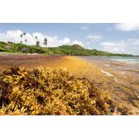
Massive Bloom of Brown Seaweed Heads Toward Florida and the Caribbean
grows faster in warmer water, I believe it’s more plausible that the cause is a drastic increase in agricultural activity in the Brazilian Amazon.Scientists have shown that huge brown tides that were observed in the Gulf of Mexico in 2005 and 2011 were linked to nutrients carried down the Mississippi River. Now, intensive cattle ranching and soybean farming in the Amazon basin are sending rising levels of nitrogen and phosphorus into the Atlantic Ocean via the Amazon and Orinoco rivers. These nutrients are key ingredients in fertilizer, and also are present in animal manure.Another major source
Ballast Water Management is Reducing the Flow of Invasive Species into the Great Lakes
illegally to a Québec fish farm in the mid-1980s and now expanding its population in the St. Lawrence River.Meanwhile, four non-native species of carp (bighead carp, silver carp, grass carp and black carp) raised in fish farms in the southern United States have been spreading throughout the Mississippi River basin over the past several decades and pose an ongoing risk of invading the Great Lakes. Grass carp has been found reproducing in Lake Erie tributaries and is poised to invade parts of the basin.Finding new strategies to manage these risks is vital to conserving biodiversity and protecting
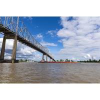
Corps Building Underwater Sill to Halt Saltwater Intrusion in Mississippi River
The U.S. Army Corps of Engineers, New Orleans District began construction of an underwater sill October 11, 2022, across the bed of the Mississippi River channel to prevent further upriver progression of salt water from the Gulf of Mexico.The Mississippi River’s volume of water has fallen to a level that allows salt water to intrude upstream. Saltwater from the Gulf of Mexico moves upriver in a wedge shape that may stretch up approximately 20 miles from the bottom to the surface of the river.To stop the salt water from moving upriver and reduce the risk to freshwater intakes, the New Orleans
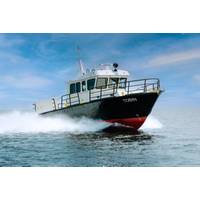
Silver Ships Delivers Survey Vessel to US Army Corps of Engineers
of Engineers Venice Sub Office in Venice, La. The 49-foot Tobin is the latest expansion in Silver Ships’ Endeavor series of workboats and is the largest marine surveying vessel of its series.Custom designed for the U.S. Army Corps of Engineers to hydrographically map the mouth of the Mississippi River, the mission-specific vessel will allow researchers to accurately and effectively obtain and document data on the rapidly changing waters in the Mississippi River. With the intent of keeping waterways open and preventing obstructions to marine navigation, Tobin is equipped to handle challenging