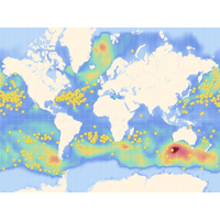
NOAA and Sofar Advance Weather Forecasting
interface, GFDL and Sofar fill the observational gaps left by other data sources. Spotters, for example, deliver highly accurate wave and weather data amidst the heavy convection, rain, and clouds typical of storms at levels not possible for satellites. Sofar and GFDL, along with NOAA’s National Hurricane Center, leverage these Spotter observations to calibrate extreme weather models and initialize near real-time operational storm forecasts

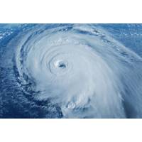
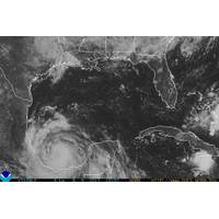
Mini USV Collects Data in a Category 5 Hurricane
for forecasters and scientists. They also take photos during their missions for immediate download and video for download after the vessels are recovered.Three C-stars entered Hurricane Humberto in intervals approximately 12 hours apart to collect real-time data to be used by NOAA’s National Hurricane Center and sent to the Global Telecommunications System to inform forecasters.One C-Star measured a minimum air pressure of 955 millibars and hurricane strength gusts of over 150 miles per hour in Humberto’s eyewall. The low air pressure measurement, together with an increase in sunlight
Where Are the Hurricanes? Quiet Atlantic Bucks Forecast for 'Super' Season
for later-season hurricanes.The two most active hurricane seasons on record, 2020 and 2005, featured cool Pacific Ocean temperature anomalies similar to those currently in place. Storm development was very frequent between September and November in both of those years.As of Thursday, the U.S. National Hurricane Center had identified five areas of disturbance in the Atlantic, more than would normally occur simultaneously.Those are not forecast to produce much at all in the way of hurricanes, but it may be a sign that the ingredients are present and a flurry of storms could be ignited should the atmosphere
Brennan Named Director of NOAA’s National Hurricane Center
NOAA has selected Mike Brennan, Ph.D., to serve as the next director of NOAA’s National Hurricane Center (NHC) in Miami, as preparations continue ahead of the 2023 hurricane season. He will assume this new role effective today, April 10, 2023.“The NHC director is one of the most visible and important jobs in the nation, and Mike possesses the right combination of experience, leadership and personal traits to prepare and guide us through major storms,” said Rick Spinrad, Ph.D., NOAA Administrator. “Alongside our trusted and dedicated team at NHC, Mike will continue to leverage
Hurricane Dorian races toward Florida
Hurricane Dorian is moving quickly through the Caribbean and heavy rains are expected in the Bahamas, Florida and the southeastof the US. this weekend, the National Weather Service has said. The National Hurricane Center said that Dorian’s winds currently have speeds of about 80 miles per hour and that the storm is moving northwest at 13 miles per hour and that the Category 1 hurricane could grow in strength to a major Category 3 storm before it potentially reaches Florida.Dorian is still moving away from Puerto Rico and the Virgin Islands and hurricane warnings and watches for those areas have
Harvey, Irma, Maria and Nate Retired
Caribbean last year, the World Meteorological Organization’s Region IV Hurricane Committee has officially retired these names. Storm names are retired if they were so deadly or destructive that the future use of the name would be insensitive - otherwise names are reused by NOAA’s National Hurricane Center on a six-year cycle. The committee also selected the replacement names for Harvey, Irma, Maria and Nate with Harold, Idalia, Margot and Nigel respectively that will first appear in the 2023 list of storm names. Including these four additions, there have been 86 names retired from

NOAA Taps Graham to Lead National Hurricane Center
Kenneth Graham has been selected to serve as the next director of NOAA’s National Hurricane Center in Miami, as preparations continue ahead of the 2018 hurricane season, which begins on June 1. He will assume this new role on April 1. “The forecasts in last hurricane season were 25 percent more accurate than average, and with new satellites and other measures they are undertaking, we are very hopeful to keep improving the timeliness and accuracy of our forecasts,” said Secretary of Commerce Wilbur Ross. “Ken will be a great leader of the Department’s efforts in
Weakened Maria Could Regain Major Hurricane Status -NHC
Maria, which weakened into a Category 2 hurricane on Wednesday, could regain major hurricane status by Thursday, the U.S. National Hurricane Center (NHC) said in its latest advisory. Catastrophic flash flooding was occurring over portions of Puerto Rico with conditions now deteriorating over the eastern Dominican Republic, the NHC said. The hurricane was about 25 miles (45 km) north northwest of Aguadilla, Puerto Rico with maximum sustained winds of 110 miles per hour (175 km per hour), the Miami-based NHC said. Any hurricane with top sustained winds of at least 111 is classified as
Hurricane Franklin Nearing Mexico
Franklin, upgraded to a Category 1 hurricane from a tropical storm, is expected to hit eastern Mexico's key oil-producing Gulf state of Veracruz on Wednesday evening or early Thursday morning, the U.S. National Hurricane Center said on Wednesday. Franklin, the first hurricane of the Atlantic's season, was packing maximum sustained winds of 75 mph (120 km/h) and was about 105 miles (170 km) northeast of Veracruz, Mexico, the Miami-based weather forecaster said. "Some additional strengthening is expected until the center crosses the coast (in the Mexican state of Veracruz). Rapid