Teledyne Acquires ChartWorld International
maritime chart display. Today, SevenCs continues to provide ENC production and distribution software, as well as software development kits for the display of electronic nautical charts in accordance with maritime standards to other navigation system OEMs.“ChartWorld’s maritime navigation software and hardware tools bridge a product and technology gap between our Teledyne Marine and Raymarine businesses,” said Robert Mehrabian, Chairman, President, and Chief Executive Officer. “Furthermore, the acquisition adds to our software capabilities and recurring revenue, while expanding
MTR100: When it Comes to Drones, Big is Good. <1m is Better.
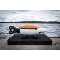
effected by the environment, as a group they can figure out the best way to approach the mission.”Photo courtesy ecoSUB RoboticsEvoLogicsWhile EvoLogics’ main products are underwater communications and positioning, the company has also been developing its own vehicles and now also navigation software, so that they can work together in swarms, react to changing conditions and communicate with a main control centre. These capabilities are being combined into vehicles like its PingGuin, a penguin shape-vehicle, but will also be able to be used with other vehicles it’s launching, as
Partners to Advance Subsea Robotic Inspection
services for the oil and gas industry. Kraken Robotics Inc.’s wholly-owned subsidiary, Kraken Robotic Systems Inc., has partnered with GE Venture Avitas Systems to integrate autonomous underwater vehicles (AUVs), acoustic and laser sensor technology and artificial intelligence-based navigation software into unique subsea inspection solutions for the oil and gas, offshore renewable energy and shipping industries. The announcement was made during GE's Mind + Machines event in San Francisco, Calif. "Bridging Kraken's cost-effective technologies with our autonomy, state-of-the-
Next-Generation Subsea Metrology: Better Measurements, Fast
class Triton XL WROV Facilities for guests from Operators and Contractors HSEQ Control Sonardyne •Acoustically Aided Inertial Navigation System, comprising: •SPRINT Inertial Navigation System (INS) •SYRINX Doppler Velocity Log (DVL) •Fusion navigation software •Janus INS Post-Processing software Micro-Compatt 6 acoustic transponders 2G Robotics / Seatronics ULS 500 Pro Laser Scansoft laser control & QC software Subsea gyro packages for bespoke subsea target structures Key integration cabling DOF
OSI Maritime Systems’ ECPINS Earns MED Type Approval
is an advanced Warship ECDIS with military capabilities well beyond the commercial ECDIS standards. Canada, the U.K., Australia, New Zealand, Denmark, the Netherlands and Portugal are among the navies operating fleet wide ECPINS Warship or ECPINS Submarine. Of the three electronic navigation software choices offered by OSI (i.e., ECPINS, ECPINS Warship, and ECPINS Submarine), ECPINS Submarine is the most comprehensive and feature rich solution
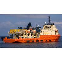
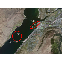
UTEC Comes up Big Offshore
operations, increase cost savings on an original scope of work, provide greater precision, increase efficiencies and thereby reduce job time. UTEC conducted the project using a combination of acoustics and inertial positioning technology. A key element was the creation of an improved navigation software package incorporating the latest NavView technology from data and positioning analysis expert 4D Nav. The system provided enhanced and precise positioning awareness along with the management of inertial sensors and a bespoke link to FairfieldNodal’s data acquisition system. The
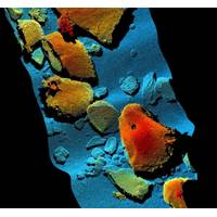
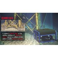
Underwater Laser Scanner Aids 3D Mobile Mapping
to a remotely operated underwater vehicle (ROV). For the survey, the ROV was equipped and navigated using Sonardyne’s inertial navigation sensor SPRINT interfaced with a Syrinx 600 kHz DVL, ROVNav 6 LBL transceiver and a precision pressure sensor. EIVA’s hydrographic survey and navigation software was integrated with the ULS-500 using EIVA’s dedicated driver for 2G Robotics’ systems to facilitate with data capturing and post-processing. Sonardyne noted that laser mobile mapping is dramatically faster than static scanning, enabling wide areas to be covered quickly and
Project Mars: The future of Autonomy
marine vessels for a variety of global customers. The contemporary vessel, designed by the multi award-winning Shuttleworth Design, will operate as a research platform, conducting numerous scientific experiments during the course of its voyage. MARS will also be used as a test bed for new navigation software and alternative forms of power, incorporating huge advancements in solar, wave and sail technology. Phaneuf explains, “One of the key aims has always been to ensure the Mayflower Autonomous Research vessel is powered from renewable sources, and that will include solar power and wind
Acteon Partners Win Heavy Lift Survey Support Deal
been designed to meet the high accuracy installation tolerances required for each pile cluster, with UTEC NCS using the specifically designed heavy lift / renewables internal software package “Groundbase” to monitor the installations. Groundbase is a customized, stand-alone, navigation software package developed to provide the necessary QC for any offshore structure installation. Capabilities include monitoring: jackets, top-sides, monopiles, transition pieces, templates, manifolds etc. when installed from vessels, barges or jack-ups. LDD is contracted by Offshore Wind Force


