New Study Tracks Trash Found at the Ocean's Depths
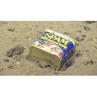
meters depth on Enigma Seamount off the Mariana Islands. (Image courtesy of the NOAA Office of Ocean Exploration and Research, 2016 Deepwater Exploration of the Marianas)Glass debris – a glass bottle at 1,152 meters depth at Titov Seamount in the Howland and Baker Unit of the Pacific Remote Islands Marine National Monument. (Image courtesy of the NOAA Office of Ocean Exploration and Research, Discovering the Deep: Exploring Remote Pacific MPAs)Metal, glass, plastic, rubber, cloth, fishing gear and other debris were encountered during 17.5% of the 188 dives reviewed, at depths between 150 and 6
Recovery Comes Slowly for Central Pacific Coral
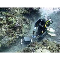
Nearly one year after prolonged high ocean temperatures caused devastating coral bleaching and loss in parts of Pacific Remote Islands Marine National Monument, NOAA scientists recently went back to check on their condition. Healthy coral reefs protect shores from storms and offer habitats for fish and other marine life, including ecologically and economically important species. After corals die, reefs quickly degrade and the structures corals build erode. While corals can recover from mild bleaching, severe or long-term bleaching is often lethal. Jarvis Island, one of the most remote
NOAA's Okeanos Explorer Journeys Into Pacific Deepwater
the sciences among young people – perhaps leading to the next generation of ocean explorers.” The 2017 expeditions will take place in and around the National Marine Sanctuary of American Samoa, the Rose Atoll Marine National Monument, the Musicians Seamounts, and the Pacific Remote Islands Marine National Monument, including the areas of Howland, Baker and Jarvis Islands, Palmyra Atoll and Kingman Reef, and Johnston Atoll. While this year’s dives will focus on waters of the United States Exclusive Economic Zone, NOAA will partner with several Pacific Island countries to explore the
Exploring Protected Areas and Shipwrecks in the Pacific
battle." The Okeanos Explorer 2016 field season will continue into the spring and summer, focusing on the deep water environments of the Commonwealth of the Northern Marianas Islands (CNMI), the Marianas Trench Marine National Monument, and the Wake Atoll section of the Pacific Remote Islands Marine National Monument, which President Obama expanded in September 2014. Telepresence technology will be used during portions of these expeditions as well, allowing scientists to participate from shore, while the public tunes in to view the exploration in real-time. Expected ROV expedition
Obama Plans to Create World's Largest Marine Protected Area
The proposed Marine Protected Area (MPA) is in the middle of the Pacific Ocean where the White House intends to extend an existing protected area, known as the Pacific Remote Islands Marine National Monument, where fishing and drilling would be banned over an area of about 2-million sq. km. The Pacific Remote Islands Area is controlled by the US and consists of seven scattered islands, atolls and reefs that lie between Hawaii and American Samoa. In the main uninhabited, the waters that surround these remote islands are home to a wide range of species including corals, seabirds, sharks and