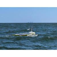
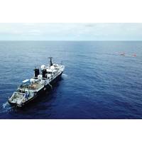
USV Provides Near Real-Time Deep Ocean Current Observations
HPT 7000 transceiver. The solar and battery powered SP-48 was tasked with navigating variable ocean currents and weather conditions in the Gulf to reach the sensor locations and harvest the data. It was then able to send the science-ready data to shore through its dual iridium and Starlink satellite links, which also enabled high-data rate and real-time communications back to shore. In total, three deployments covering more than 30 days, the SP-48, which can sustain 2 to 3kt operations and sprints up to 5kt, covered around 1,500nm. During this time, more than 135 GB of high-resolution ocean
Connecting the Dots: From Remote Operations to Full Autonomy
problems given that satellite connections can be intermittent and unreliable with limited bandwidth capacity.”Ford explained that Harvest’s RiS was developed to enable the transmission of quality video and the associated metadata along with clear and reliable audio system over these satellite links or networks, meaning operators could transform how they worked without needing to change the infrastructure they worked with.“The solution itself is unique; it's intuitive, it's functional, but most of all, it's reliable and the only system we know of specifically designed
Subsea Defense: Navy Deepens Commitment to Underwater Vehicles
form and intensify.Today, a third of those gliders are deployed operationally around the world at any given time, controlled by pilots at the Naval Oceanographic Office (NAVO) Glider Operations Center located at Stennis Space Center, Mississippi. The pilots communicate with the glider with Iridium satellite links to collect oceanographic data such as water temperature, salinity, water clarity and depth, and provide positioning and course instructions.Gliders can operate in remote locations for extended missions to collect data, or deployed in conjunction with major fleet exercises to give participants
12-meter Ship Aims to Be First to Cross Atlantic Without a Crew
pick-up vehicle of the sea, it's robust, it's adaptable, it's got a huge range," said SEA-KIT International Managing Director Ben Simpson.The vessel is operated by a hand-held remote control when in harbor and when at sea it can stream live data to the controller via multiple satellite links."What is now available through technology is very, very similar to what you have on the bridge of a ship and in many ways, I would argue, even more comprehensive," said James Fanshawe, a director of SEA-KIT."The controller here in this station can actually see all the way round
A SmallSat AUV Network
There’s more to a global network than satellite links, and yet sat-linked remote operations experts can heap huge scientific and technological gains on the world. That’s what’s happening in the background — a smallish network of the best scientists from around the world are orchestrating the communications and robotics that’ll yield groundbreaking achievement in the networked use of autonomous underwater vehicles, or AUVs.If you contact Professor Kanna Rajan, as we did, he’ll tell you he’s not the world’s foremost “drone” researcher, yet

Ashtead Secures Deal with nCentric
networks from its offices across the globe. Tim Sheehan, commercial director at Ashtead Technology said, “Capturing data from remote locations is still a major challenge for the industry. Today, most communications from oil and gas platforms and vessels to shore depend on expensive satellite links. The nCentric technology delivers a cost effective, efficient and reliable wireless network in large, hard-to-reach geographical areas.” The nCentric technology can be used to monitor offshore operations, increase communication and can relay high definition footage from Remotely

Maritime Surveillance in the New Millennium
track picture while alarm zones based on proximity and predetermined characteristics detect and trigger events like slewing cameras or LRADs towards the threat and send out a warning. Remote monitoring and control capability sending sensor data and control messages over low-bandwidth radio and satellite links provide owner/operators of platforms an additional surveillance capability. Conclusion A primary goal of a robust SA system is to sharpen the operator’s perception of the surrounding environmental elements with respect to time and/or space. Experienced operators of robust SA systems
New Launches, Demonstrations Set for Seawork
, including Interceptor and Multicats, on its own custom-built 540m2 pontoon. Sabik will be launch and demonstrate its new remote monitoring system for navigational aids; the LightGuard Monitor, which is designed for easy integration into an existing monitoring centre and works with satellite links or via a GSM network. The Bilge-Bug, being launched by Excel Marine at Seawork International, has been designed and engineered in the UK to provide safe and reliable clearance of bilge water. Harken Industrial will debut its new self-tailing, man-riding winch with
Sailing for Science
R/V Atlantis,” she said. Jason and other ROVs can be operated from many of the ships in the Federal Oceanographic Fleet but require special winches and control vans (or labs). Houtman said NSF is developing new mooring arrays as part of the Ocean Observatories Initiative that will have satellite links and the ability for Autonomous Underwater Vehicles (AUVs) to dock with the array without surfacing to recharge, exchange data and receive instructions. There’s been a significant investment in new technology, Houtman said, particularly with unmanned, off board systems such as buoyancy


