Curtin, NASA Tap Ocean Information from Space
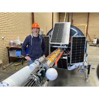
Sensing and Satellite Research Group (RSSRG) in the School of Earth and Planetary Sciences, said the new optical system, known as MarONet (Marine Optical Network), deployed near WA’s Rottnest Island will play a critical role in verifying - or ‘ground-truthing’ - PACE’s satellite observations.“We typically think of the ocean’s colour as blue, but in many places, it looks blue-green because those areas are teeming with single-celled plants called phytoplankton, which contain chlorophyll and absorb the blue light,” Professor Antoine said.“Phytoplankton are
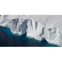
Artificial Submarine Curtains Won’t Save West Antarctica’s Retreating Glaciers
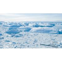
is the sector of West Antarctica currently losing most ice. NASA Earth Observatory, CC BY-SAThis warm water drives some of the highest rates of ice-shelf melting seen on the continent and is causing the ice to thin and retreat rapidly. Recent research suggests this retreat is now unavoidable.Satellite observations have shown extensive thinning and retreat of glaciers in this region. Some scientists are concerned that this sector has already passed a threshold for irreversible retreat.The Amundsen Sea Embayment has been identified as the most vulnerable sector of the ice sheet because the glaciers there
Maersk Vessels Transmit Live Weather Data to Meteorologists
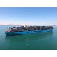
have been gathered and shared on a systematic basis for over 150 years. They provide essential data on meteorological conditions at sea for weather forecasts and, over long-time scales, help climate scientists understand climate change. Ship observations, alongside other ocean, land-based, and satellite observations, are used in global and regional climate analyses, and are combined with atmospheric-ocean climate models, that depict the evolution of our environment. These observations also help to ensure safety at sea by allowing better forecasting of storms and other extreme ocean-related events for
Hidden Behavior of Arctic Ocean Currents Could Alter Climate Change Predictions, Study finds
.”Scientists from the National Oceanography Centre (NOC) and Alfred Wegener Institute (AWI), collaborating within the Advective Pathways of nutrients and key Ecological substances in the Arctic (APEAR) project, used high resolution, realistic ocean and ice model simulation, alongside satellite observations to compare the flow of two sets of particles starting from the same location. A key observation indicated that there were differences in terms of the length of time the particles took to drift across the Arctic and how quickly they spread out from the Transpolar Drift. These key differences
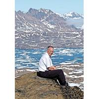
50 Years from Now: Perspectives Dr. Ralph Rayner
by an order of magnitude. Numerous ocean observation satellites now circle the planet, observing everything from sea surface temperature and salinity, to wave heights and currents. A vast array of instrumentation is now in use to measure and monitor the oceans. Combined with satellite observations, these measurements have enabled an unprecedented understanding of how the ocean works and enabled predictions about its future.Our observations, measurements and forecasts of the ocean, and of the environment more generally, are now telling us that we face an existential threat as we grapple
Arctic Sea Ice Lows Mark a New Polar Climate Regime
predicted by the previous climate,” Landrum explained. “The year-to-year variability, the change in many of these parameters, is moving outside the bounds of past fluctuations.”Sea ice coverage minimums, in particular, are now about 31% lower than in the decade after 1979, when satellite observations began. The ice has also lost about two-thirds of its bulk, as much of the thicker ice layer built up over years has long since melted away. The current ice regime actually began about two decades ago, the study found.This vanishing of sea ice also contributes to the region’s warming
OceanObs’19: Innovation Expanding Ocean Observations
has historically taken an artisanal approach, much like craft beer, focusing on quality over scalable solutions. He suggested we needed to move from this artisanal approach to scalable tools and noted that the use of robotic ocean systems is the only realistic approach; they complement surface satellite observations and provide a critical third dimension over the global ocean. Further the presentation offered a rationale to increase observational capacity by a factor of 1000. Of course, with current technologies this would be prohibitively expensive. But the idea leads to a potential demand for 350,000
EOMAP Wins Funding for Next-Gen Satellite-Derived Bathymetry
EOMAP has been awarded by the German Aerospace Center (DLR) to further develop its physics-based method of mapping the depth of the sea from satellite observations.Satellite-Derived Bathymetry (SDB) uses data gathered by satellites and aircraft to generate depth measurements and seafloor characteristics for regions of shallow water. Developed 20 years ago by EOMAP scientists then at DLR (Germany) and CSIRO (Australia), SDB’s potential to create a continuously updated global database of shallow-water bathymetry is hampered by the heavy computing power required to process the large amounts of data
Strong El Niño Events Cause Large Antarctic Ice Loss -Study
Fricker, discovered that a strong El Niño event causes ice shelves in the Amundsen Sea sector of West Antarctica to gain mass at the surface and melt from below at the same time, losing up to five times more ice from basal melting than they gain from increased snowfall. The study used satellite observations of the height of the ice shelves from 1994 to 2017. “We’ve described for the first time the effect of El Niño/Southern Oscillation on the West Antarctic ice shelves,” Paolo said. “There have been some idealized studies using models, and even some indirect


