
Teledyne ADCP Selected for 63-ft. Hybrid Ocean Monitoring Vessel
of the ocean currents from near surface to near bottom, is the perfect tool we needed to optimize the utility of the vessel we’re building”.The vessel built by AAM will enable OC San to carry out environmental monitoring, marine research, and ocean sampling efficiently in the Southern California Coast. The ADCP will help inform OC San’s Ocean Monitoring team on current movements during complex oceanographic research and sample collections. The ADCP data will be used to augment OC San’s water quality program and support the National Pollutant Discharge Elimination System (NPDES)
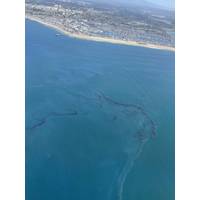
'Catastrophic' California Offshore Oil Spill Kills Fish, Damages Wetlands
A large oil spill off the southern California coast left fish dead, birds mired in petroleum and wetlands contaminated, prompting local officials to call it an environmental catastrophe.The U.S. Coast Guard, heading a clean-up response involving federal, state, and city agencies, said on Sunday there was an around-the-clock investigation into how the spill occurred.An estimated 126,000 gallons, or 3,000 barrels, had spread into an oil slick covering about 13 square miles of the Pacific Ocean since it was first reported on Saturday morning, said Kim Carr, the mayor of Huntington Beach, at a press

Research Vessel Delivered to Orca Maritime
Hunt Photography / Armstrong Marine)The catamaran features a full-width cabin with fly bridge, large aft working deck, hydraulic A-frame (5,000 lb. SWL), Northern Lights 9kw diesel generator, and Garmin/NMEA electronics package. The vessel is well equipped for multi-day operations along the Southern California coast with two interior work stations, a 4-person sleeping cuddy, head with shower, refrigerator/freezer, and 600-gallon fuel capacity.Benthic Cat is powered by twin Volvo Penta D11 510hp inboards paired with Volvo IPS 650 propulsors and Volvo electric steering. Builder sea trials indicated 32mph
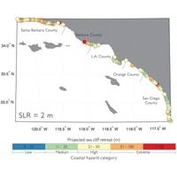
Sea Level Rise Could Speed Erosion in Southern California
By the year 2100, coastal cliffs from Santa Barbara to San Diego might crumble at more than twice the historical rate. Why?U.S. Geological Survey scientists combined several computer models for the first time to forecast cliff erosion along the Southern California coast. Their peer-reviewed study published in a recent issue of the American Geophysical Union’s Journal of Geophysical Research - Earth Surface showed that for sea-level rise scenarios ranging from about 1.5 feet to 6.6 feet by 2100, bluff tops along nearly 300 miles of Southern California coasts could lose an average of 62 to 135


