Sea Level Rise Could Speed Erosion in Southern California


-
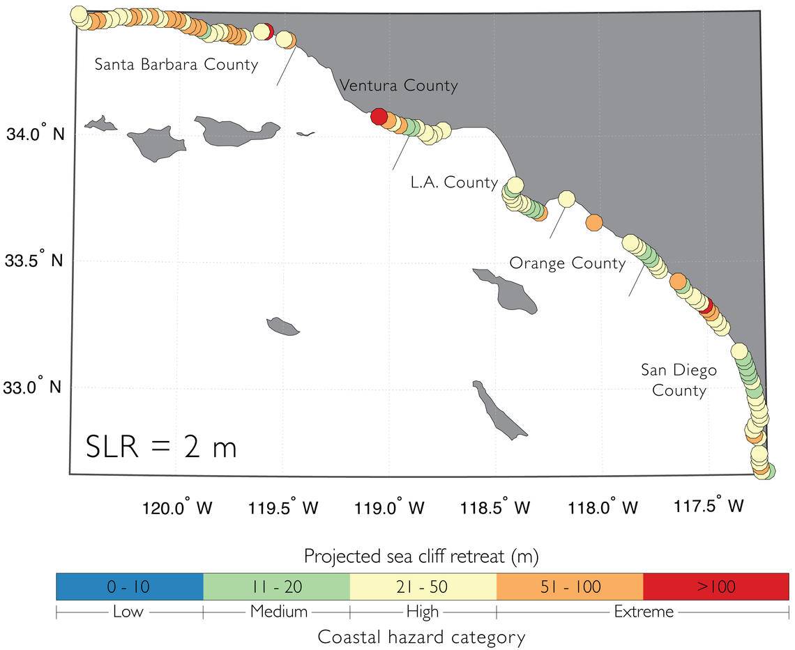
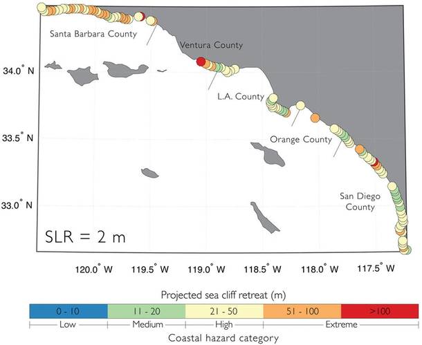 Map of Southern California coastline showing cliff retreat forecasts using 6.6 feet of sea level rise. Orange and red circles indicate extreme erosion beyond 167 feet. (Image: USGS)
-
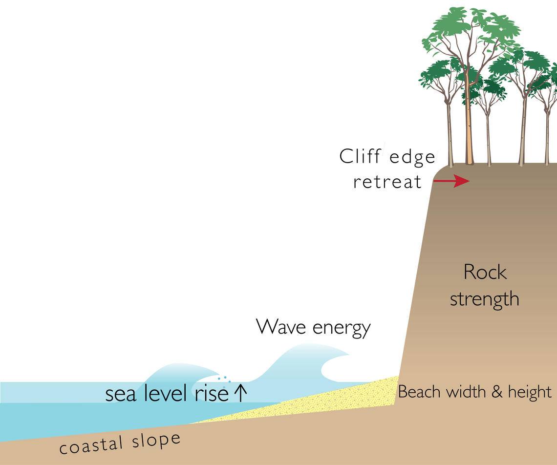
 This diagram shows the factors that can affect coastal cliff erosion, including sea level rise, wave energy, coastal slope, beach width, beach height and rock strength. (Image: USGS)
By the year 2100, coastal cliffs from Santa Barbara to San Diego might crumble at more than twice the historical rate. Why?
U.S. Geological Survey scientists combined several computer models for the first time to forecast cliff erosion along the Southern California coast. Their peer-reviewed study published in a recent issue of the American Geophysical Union’s Journal of Geophysical Research - Earth Surface showed that for sea-level rise scenarios ranging from about 1.5 feet to 6.6 feet by 2100, bluff tops along nearly 300 miles of Southern California coasts could lose an average of 62 to 135 feet by 2100 – and much more in some areas.
“Sea cliff retreat is a serious hazard,” said USGS research geologist and lead author Patrick Limber. “Unlike beaches, cliffs can be stable for decades between large landslides that remove several feet of bluff top.”
USGS developed this forecast to help managers and policy makers understand how the coastline is going to respond to sea level rise over the 21st century, enabling them to make better-informed decisions.
Coastal cliff erosion rates vary depending on sea level rise, wave energy, coastal slope, beach width and height and rock strength.
USGS researchers combined five different computer models that forecast how cliffs crumble in a manner similar to how meteorologists blend several hurricane forecasts to get the best predicted path of the storm. This is the first time anyone has reported an “ensemble forecast” for cliff retreat that produces a range of values for each section of coastline instead of each model yielding one number. Scientists used earlier studies to supply the erosion models with sea level rise values from 1.6 to 6.6 feet, long-term wave energy forecasts and other data.
The study also noted that without the supply of sand from eroding cliffs, beaches in Southern California may not survive rising sea levels – and bluff-top development may not withstand the forecasted 62 to 135 feet of cliff recession. “Consequently,” wrote the study’s authors, “managers could be faced with a difficult decision between prioritizing private cliff-top property or public beaches by permitting or prohibiting cliff armoring, respectively.”
Yet these forecasts have limits. “There’s a lot about cliff erosion that we still don’t understand,” said Limber. “Caution should be exercised when applying this on a site-specific scale because the uncertainty is large. More research needs to be done so that the uncertainty is reduced.”
This study is part of a broader USGS-led effort to forecast climate change impacts across the Southern California coast using the Coastal Storm Modeling System.
“Coastal change, cliff retreat, sea level rise, and extreme storms could expose more than 250,000 residents and $50 billion in property to erosion or flooding in Southern California by the end of the century,” said Patrick Barnard, a USGS research geologist and co-author of the journal article.
The new study, “A model ensemble for projecting multi-decadal coastal cliff retreat during the 21st century,” by Patrick Limber, Patrick Barnard, Sean Vitousek and Li Erikson is available online.