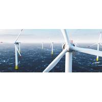
Using Ocean Robots to Dive into Offshore Wind Farm Wake Effects
tells us about how much phytoplankton there is.This includes highly sensitive sensors such as a shear probe and a piezoceramic oscillator, which helps to measure turbulence in the ocean by recording extremely small forces at 512 times a second.From just off Arbroath, they make their own way out to the survey site, around 17 miles offshore. There, they run 10-mile lines, east to west, going up and down in the water column, gathering data as they go to build a three-dimensional picture over time. Every three hours, they surface to ping their data back to shore and check-in for any mission updates.Establishing
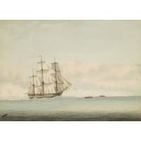
Has Captain Cook’s Ship Endeavour Been Found?
Endeavour or not. But I have worked on many shipwreck investigations and have been involved in the discovery of a couple of shipwreck sites of this period.So I can share a little bit about what’s usually involved in trying to piece together the identity of a ship when a wreck is found.From the survey site to the labThe first thing you will need is a detailed survey of the site. The process is similar to an archaeological survey on land, but for most shipwrecks you will be underwater. That makes it more difficult to take measurements precisely. Nowadays we also use 3D imaging techniques, high-resolution
Global Reef Expedition: Mission to Tonga
officials in Tonga and are available to explore on the Khaled bin Sultan Living Oceans Foundation World Web Map Portal (http://maps.lof.org/lof).To verify the accuracy of these maps, an underwater tethered video camera, called a drop-cam, was used to gather video of the benthic composition at each survey site. At each point, the drop-cam was suspended from the survey boat enabling it to “fly” along the sea floor recording video, geographic position, time, date, heading, and speed. Some of these geo-referenced clips from the drop-cams are available to view on the KSLOF online Map Portal
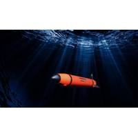
Untethered Vehicle Tech Continues to Advance Autonomy
vision is efficiency with scale of operations and reliability from many interchangeable vehicles, which they term AxVs.The Terradepth Concept of Operations (CONOPS) includes: 1) surface and subsurface capability, 2) two or more identical vehicles, 3) launch from shore or sea, 4) open ocean transit to survey site, 5) extended time at sea, 6) multi-vehicle cooperation, and 7) Precision data gathering. This is executed via a single configuration of hybrid autonomous marine vehicle surface and subsurface system. Terradepth has a patent pending for this CONOPS and is currently preparing for initial demonstrations
Good Undersea Vehicles Come in Small Packages
, RangerBot became smaller, easier to use, and more affordable than typical alternatives. Using a series of cameras, the RangerBot can manage its horizontal course over the bottom as well as its depth. Using the latest photo mosaic tools, the vehicle can also produce useful data products over a survey site. The visual systems also allow for complex environmental management applications.RangerBot, and its predecessor prototypes, has proved able to identify crown of thorns starfish (COTS), a predator that can ravage coral reefs. The AUVs have also demonstrated the ability to carry a payload that can
Underwater Laser Mapping on the Move
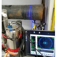
high-resolution laser data is no longer constrained by a stationary deployment location which means an entire site can now be surveyed quickly and with the flexibility to overcome adverse conditions such as visibility. As the underwater vehicle does not have to come into contact with the seabed at the survey site, it can move to scan any target of interest from a variety of perspectives. This results in archaeological surveys, pipeline and free span inspections, structural integrity monitoring and one of the most demanding of all survey tasks, pipeline metrology, all being conducted in much less time than
Partners Developing Dynamic Subsea Laser Mapping
high-resolution laser data is no longer constrained by a stationary deployment location. This means an entire site can now be surveyed quickly and with the flexibility to overcome adverse conditions such as visibility. As the underwater vehicle does not have to come into contact with the seabed at the survey site, it can move to scan any target of interest from a variety of perspectives. Through the agreement, both 2G Robotics and Sonardyne, as well as their distributors, can now offer a complete package for dynamic scanning. Edward Moller, Global Business Manager for Construction Survey
Gavia AUV Gets a Sonar Upgrade
and pipeline survey, environmental survey and under ice survey, as well as Mine Countermeasures (MCM), Rapid Environmental Assessment (REA) and Intelligence, Surveillance and Reconnaissance (ISR) surveys. The modular Gavia AUV can carry an array of sensors and custom payload modules to a survey site in up to 1,000m water depth for research, monitoring, survey or surveillance tasks. Equipping the Gavia AUV with the survey-grade long range side scan from Klein Marine Systems creates a highly mobile survey platform with high quality side scan range and resolution. The swath bathymetry
Deep Ocean Engineering
as a gift to the National Park Service. In the months leading up to this survey, R2Sonic contacted Deep Ocean to use its their H-1750 USV as an unmanned platform to operate their SONIC 2020 multibeam. Typically, these surveys are completed using a 2-3 manned vessel with an affixed multibeam but the survey site above the USS Arizona has a height restriction where a manned vessel cannot navigate. The memorial building that straddles the USS Arizona makes for a low ceiling above the water at various tides. Couple that with the shallow depth of water above the sunken ship and there is a very tight set of