Marine Technology News Search
Search term • "advanced navigation"
Create an email alert for "advanced navigation"
Exceptional Imagery for Bluefin with Sonardyne Solstice
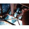
Following the integration of Sonardyne International Ltd.’s Solstice Side Scan Sonar with a Bluefin Robotics Bluefin-12 Autonomous Underwater Vehicle (AUV), the results of recent payload testing have produced higher quality imagery than that currently available from conventional sonar. The most recent trials of the Bluefin-12 AUV with integrated Solstice were conducted from Bluefin Robotics’ headquarters in Quincy…

Shell Ocean Discovery XPRIZE Semifinalists Announced
XPRIZE today announced the 21 teams representing 13 countries advancing in the $7 million Shell Ocean Discovery XPRIZE, a three-year global competition challenging teams to advance ocean technologies for rapid, unmanned and high-resolution ocean exploration and discovery. Their innovative approaches run the gamut: gliders and drones, underwater robotic swarms, autonomous underwater vehicles, robotics, artificial intelligence and massive computing platforms.
ABB HVDC Technology Aids Offshore Wind Power Transmission
World’s most powerful HVDC Light® sets new record voltage level of ±320 kV- more than 50 per cent higher than existing record. The HVDC Light converter station was energized at the Dörpen West substation in northern Germany, for the Dutch-German transmission system operator, TenneT. This station is the receiving end of the DolWin1 transmission link, which will integrate 800 MW of offshore wind power…
IEA Reports Stalled EffortsToward Clean Energy
The rapid expansion of renewable technologies is one of the few bright spots in an otherwise bleak assessment of global progress towards low-carbon energy, the International Energy Agency (IEA) said in an annual report to the Clean Energy Ministerial (CEM). “The drive to clean up the world’s energy system has stalled,” IEA Executive Director Maria van der Hoeven told the CEM, which brings together ministers representing countries responsible for four-fifths of global greenhouse-gas emissions.
The eLPP: Lamor’s New Power-Pack
Lamor Corporation launched its next generation smart eco Lamor Power Pack (eLPP 55-80) at Spillcon in Cairns, Australia. The eLPP is one unit with multiple functions to operate several oil spill response units: skimmers, pumps and boom reels simultaneously, as well as other hydraulically driven equipment with green technology. In staying ahead of new and stricter legislation, Lamor eLPP series has…
Economics of Dyneema-based Ropes
Traditionally thought an expensive alternative to traditional steel wire and conventional polyester-based synthetic ropes, offshore ropes and mooring systems made with Dyneema have been making inroads. End users such as ConocoPhillips, Shell and Petrobras are working with systems based on the high-strength, low-weight fiber of DSM Dyneema. Coupled with their durability and longevity, these rope systems…
Maritime Spy Kit Installed on New Bombardier Planes
Sweden's Saab said on Wednesday it plans to put its Swordfish maritime patrol system on two new aerial platforms as demand rises for ways to tackle maritime threats, including the proliferation of submarines. The move to put an enhanced version of its Intelligence, Surveillance and Reconnaissance (ISR) systems on new airframes in partnership with Canada's Bombardier emerged at the Singapore Airshow as tensions escalated in the South China Sea.
President Obama and Falcon Help to Light up the Brain
Glowing and fluorescent deep-sea creatures could help reveal how the mind works. Bright bioluminescent and fluorescent proteins found in marine life, when attached to human cells, become light-emitting markers that could help map the brain. President Obama’s newly announced Brain Activity Map project, gives impetus to the quest for understanding the human mind. Alzheimer’s and other diseases of the mind, along with cancer, could benefit from tracing otherwise invisible nerve damage.
CAN-DO Approach Leads to £200m of Contract Renewals
CAN Group has secured two major contract renewals, totalling approximately £200million, following competitive re-tendering. These two contracts, coupled with an increase in business, will lead to the safe-guarding of 150 jobs. The Aberdeen headquartered business has been awarded a five year contract for the provision of asset integrity services to ConocoPhillips and a three year contract for the provision of topsides inspection and integrity support services with Apache in the North Sea.

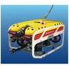
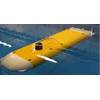
Rovco Dives into International Waters
U.K.-based startup Rovco has taken its firsts steps into international waters with the completion of two subsea survey contracts in Southeast Asia and the Middle East. The contract awards saw Rovco perform advanced subsea survey work in Fiji and Oman, utilizing its SubAtlantic Mojave, Seaeye Falcon and VideoRay Pro 4 ROVs. Launched in September, the company has also been awarded its first ROV consultancy project with one of a U.K.
BigOceanData Rolls out Gen-Next Vessel Tracking System
A new name has joined the vessel tracking sector with a product that promises to set new standards in functionality and user-friendliness. BigOceanData is the new brand from Globavista, the professional vessel tracking and monitoring provider trusted by industry professionals and government agencies alike. BigOceanData is a completely new service designed to meet the needs of today’s maritime sector: a web-based…
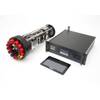
Kraken Delivers Deep-Sea Sonar System to IOSB
Kraken Sonar Systems Inc. has delivered a deep-sea rated Interferometric Synthetic Aperture Sonar (INSAS) system to Germany’s Fraunhofer Institute for Optronics, System Technology and Image Exploitation (IOSB), the company announced today. Fraunhofer is the leading organization for applied research in Europe. Under the terms of the contract, Kraken has successfully designed, engineered and delivered a 6…
TGS Begins Seismic 3D Survey West of Scotland
TGS says it has commenced acquisition of a new 3D multi-client survey in the West of Shetland region.The survey will cover 2,500km2 and will tie into TGS' existing 3D library in the region, bringing the total volume of recent TGS 3D in the area to more than 17,500 km2. The broadband seismic data will be acquired by the M/V Polarcus Naila towing 12 streamers at 6,000 m cable length. Data processing will be performed by TGS using its proven proprietary broadband technology, Clari-FiTM.
Foster Wheeler Wins Contract For Retrofit-SCR System
Foster Wheeler AG (Nasdaq: FWLT) announced today that a subsidiary of its Global Power Group has been awarded a contract by Turun Seudun Energiantuotanto Oy (TSE) for the design, supply and erection of a retrofit-selective catalytic reduction (SCR) system for TSE’s Naantali unit 3 in Finland. Foster Wheeler has received a full notice to proceed on this contract. The terms of the agreement were not disclosed…
Kongsberg, KBC Enter Upstream Partnership
Kongsberg Oil & Gas Technologies AS and KBC Advanced Technologies, a provider of consulting and software solutions to the hydrocarbon processing industry, announced they will collaborate in key areas focused on improving production solutions for upstream operators. To reinforce the relationship, Kongsberg made an investment in the recent KBC share placing to demonstrate interest in KBC’s growth strategy in upstream oil and gas.
AMIRIX's Acquisition of HTI Finalized
An agreement has been reached for AMIRIX Systems, Inc of Halifax, Nova Scotia, Canada to acquire Hydroacoustic Technology, Inc (HTI) of Seattle Wash. The acquisition became official on February 1, 2017. HTI will operate as a new business unit under the name HTI-Vemco USA, Inc. alongside the VEMCO business unit of AMIRIX to create a comprehensive provider of acoustic products, tools and services for aquatic animal monitoring.
India May Add Japanese Soryu-Class Submarines to its Fleet
India is reportedly considering a project to incorporate six Japanese Soryu-class diesel-electric submarines into its fleet, says The Japan Times. The Defense Minister of India Manohar Parrikar has expressed his readiness to consider acquiring Soryu-class diesel-electric submarines used by the Maritime Self-Defense Force. The reports in Indian media say it is not a purchasing plan. The proposal was…
MacArtney Unveils Multiplexer at 2015 Ocean Business
MacArtney Group announced today it will launch its new NEXUS MK VII multiplexer at the 2015 Ocean Business exhibition, which will take place between April 14th and 16th at the National Oceanography Centre in Southampton, UK. The MacArtney NEXUS MK VII is a versatile HD and standard video, Ethernet, serial and multibeam sonar multiplexer based on Moog Focal 907 telemetric technology. The Nexus MK VII's power switching is software controlled via PC or using a tablet with LAN or WiFi connectivity.

Insights into Inertial Sensor Technology
SBG Systems is a leading French supplier of MEMS-based inertial motion sensing solutions. For insights of the future and direction of this niche, MTR reached out to Raphaël Siryani, co-founder of SBG Systems, for his insights. For those readers not familiar with SBG Systems, please give to us a concise overview of the company, and precisely its position in the subsea industry? The company provides a wide range of inertial solutions from miniature to high accuracy.
ONR and the Culture of Innovation and Invention
ONR & The Culture of Innovation and Invention: Adm. Matt Klunder, U.S. MTR sister publication Maritime Reporter & Engineering News recently had the honor to interview Rear Adm. Matt Klunder, U.S. Navy Chief of Naval Research. Here we share select responses that are pertinent to the subsea sector. What are your near term, mid-term and long term science and technology (S&T) objectives? It’s critical that our Sailors and Marines never go into a conflict as a fair fight.


